|
| Mesoscale Discussion 530 |
|
< Previous MD Next MD >
|
|
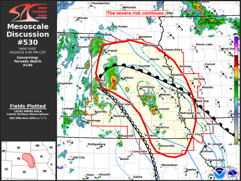
   Mesoscale Discussion 0530
   NWS Storm Prediction Center Norman OK
   0231 PM CDT Fri Apr 26 2024

   Areas affected...parts of eastern Nebraska...far northern Kansas and
   western Iowa.

   Concerning...Tornado Watch 140...

   Valid 261931Z - 262100Z

   The severe weather threat for Tornado Watch 140 continues.

   SUMMARY...The risk for large to very large hail and tornadoes
   continues across WW140. The severe risk should gradually expand
   northeastward toward the NE/IA border this afternoon.

   DISCUSSION...Several supercells have developed and matured east of
   the dryline across central and eastern NE. Several tornadoes have
   been reported thus far with the northern most cell over Greeley
   county, NE. While the storm remains in a favorable environment,
   destabilization is slowly waning as it moves into a more stable air
   mass farther north. Destabilization ahead of the storms to the south
   is expected to continue with the greater threat potentially shifting
   toward the more southern storms as the warm sector continues to
   narrow to the north. Strong low-level shear (ESRH of 250-350 m2/s2)
   near the warm front and large buoyancy will continue to support a
   risk for tornadoes (some significant) and large to very large hail.
   Additional storm development remains possible across southeastern NE
   and far northern KS, though residual capping may limit coverage
   somewhat. The severe threat should slowly expand eastward into parts
   of western IA later this afternoon or evening across the remainder
   of WW140.

   ..Lyons.. 04/26/2024

   ...Please see www.spc.noaa.gov for graphic product...

   ATTN...WFO...EAX...FSD...OAX...TOP...GID...LBF...

   LAT...LON   39559565 39469602 39499632 39639674 39889695 40239708
               40709735 41039774 41329840 41449882 41869906 42349895
               42679878 42839774 42649674 42249604 41699559 41289537
               40859524 40519524 40119536 39559565
|
|
Top/All Mesoscale Discussions/Forecast Products/Home
|
|


 @NWSSPC