|
| Mesoscale Discussion 531 |
|
< Previous MD Next MD >
|
|
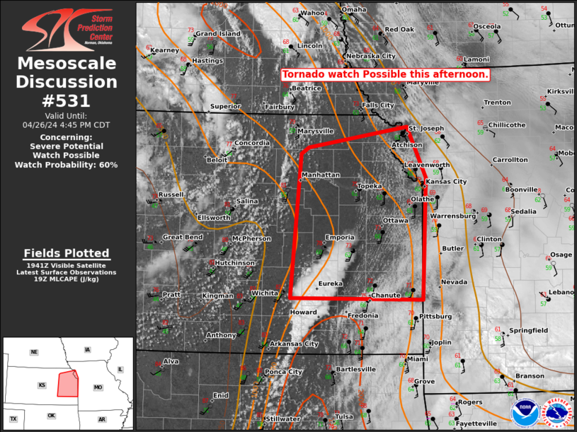
   Mesoscale Discussion 0531
   NWS Storm Prediction Center Norman OK
   0246 PM CDT Fri Apr 26 2024

   Areas affected...portions of eastern Kansas and far western Missouri

   Concerning...Severe potential...Watch possible

   Valid 261946Z - 262145Z

   Probability of Watch Issuance...60 percent

   SUMMARY...Rapid air mass recovery is underway east of the dryline in
   the wake of the early day MCS. Hi-res guidance and observational
   tends suggest isolated storm development is possible, but uncertain,
   over the next few hours. Supercells with a risk for all hazards will
   be possible and a Tornado Watch is being considered.

   DISCUSSION...As of 1940 UTC, visible imagery showed renewed attempts
   at deepening cumulus towers along the dryline across northern and
   central KS. Large-scale ascent has been steadily increasing this
   afternoon as a mid-level jet begins to impinge on the recovering
   warm sector over eastern KS and far western MO. Rapid air mass
   modification is ongoing as mid-level dry air associated with the jet
   streak has eroded lingering convective cloud debris. Dewpoints have
   increased into the low to middle 60s F in eastern KS over the last
   couple of hours as vertical mixing has deepened. Still, moderate
   inhibition remains in place as observed from ACARS soundings at MCI
   and the TOP RAOB. Continued heating, and the arrival of broad ascent
   will allow for additional destabilization with MLCAPE of 2000-2500
   J/kg likely by late this afternoon. Steep mid-level lapse rates will
   likely support strong and deep updrafts if convection is able to
   develop. Strong veering wind profiles would also favor a
   predominately supercell storm mode, with a risk for all hazards.

   The primary uncertainty is the potential for limited coverage of
   storms amid the ongoing air mass recovery. Recent hi-res guidance
   continues to indicate a few storms will likely evolve along the
   dryline this afternoon and track northeastward into northeastern KS
   and western MO. However, exactly how many storms develop, and how
   far east they will pose a threat remains unclear given the remaining
   inhibition. Still, very strong low-level shear observed from area
   VADs and large buoyancy may support a significant severe threat
   (including a strong tornado) with any supercells able to become
   established. While timing remains very uncertain, convective trends
   are being monitored for a potential Tornado Watch this afternoon.

   ..Lyons/Hart.. 04/26/2024

   ...Please see www.spc.noaa.gov for graphic product...

   ATTN...WFO...SGF...EAX...TOP...ICT...

   LAT...LON   39849484 39209455 37689460 37709670 39519655 39599642
               39849484
|
|
Top/All Mesoscale Discussions/Forecast Products/Home
|
|


 @NWSSPC