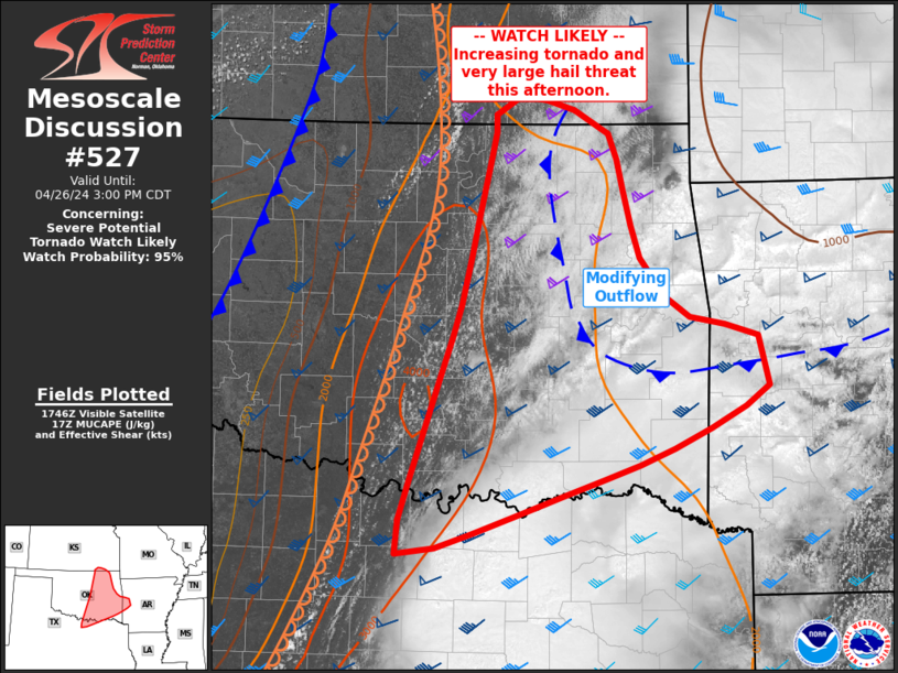
   Mesoscale Discussion 0527
   NWS Storm Prediction Center Norman OK
   1253 PM CDT Fri Apr 26 2024

   Areas affected...parts of east-central Oklahoma into far northern
   Texas and western Arkansas

   Concerning...Severe potential...Tornado Watch likely

   Valid 261753Z - 262000Z

   Probability of Watch Issuance...95 percent

   SUMMARY...At least isolated severe storms capable of tornadoes and
   very large hail may develop this afternoon over parts of eastern
   Oklahoma southward into the Red River Valley and toward far western
   Arkansas.

   DISCUSSION...Surface analysis and visible satellite clearly show the
   dryline progressing across central OK and into western North Texas,
   with gradually increasing CU fields to the east. Cool outflow
   remains over much of northeast OK into northwest AR, but dewpoints
   continue to rise just south and west of the existing outflow
   boundary.

   The 18Z OUN sounding shows an uncapped air mass and strong
   instability just ahead of the dryline. Even greater surface theta-e
   values exist south and east of the area, contributing to over 3000
   MUCAPE. Shear is also strong across the area, with around 60 kt
   effective deep layer shear, and 0-1 SRH in excess of 200 m2/s2 for
   most of the region.

   As heating continues ahead of the dryline, and clouds erode, a
   narrow zone of supercell potential will develop and at least
   isolated cells are expected later this afternoon.

   The environment will favor tornadic supercells, with potential for
   strong tornadoes, along with very large hail. The aggregated threat
   area may be relatively small in time and space, however, any
   supercells that endure may produce significant severe weather.

   ..Jewell/Hart.. 04/26/2024

   ...Please see www.spc.noaa.gov for graphic product...

   ATTN...WFO...LZK...SHV...TSA...ICT...FWD...OUN...

   LAT...LON   35209394 34799383 34269480 33879590 33419723 33369764
               33659761 34869718 35479698 36269679 36939663 37089663
               37249636 37129582 36919547 36449532 35879514 35539488
               35369464 35209394
|


 @NWSSPC