|
| Mesoscale Discussion 526 |
|
< Previous MD Next MD >
|
|
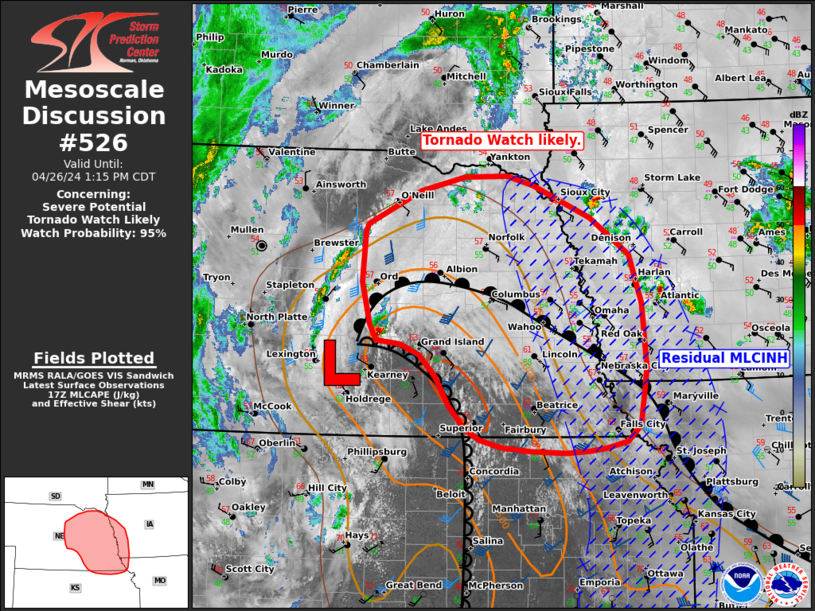
   Mesoscale Discussion 0526
   NWS Storm Prediction Center Norman OK
   1221 PM CDT Fri Apr 26 2024

   Areas affected...parts of central and eastern Nebraska ...northeast
   Kansas into southwestern Iowa.

   Concerning...Severe potential...Tornado Watch likely

   Valid 261721Z - 261815Z

   Probability of Watch Issuance...95 percent

   SUMMARY...Scattered storm development appears likely on the dryline
   within central and eastern Nebraska early this afternoon. Supercells
   with large to very large hail and tornadoes are possible. A Tornado
   Watch is likely needed.

   DISCUSSION...Rapid destabilization is ongoing within the dry slot
   ahead of an upper trough moving into the central Plains. Visible
   imagery shows towering cumulus deepening along the bent back dryline
   from near Kearney, NE to the KS border. A pocket of low to mid 60s F
   surface dewpoints has remained sheltered from deeper vertical mixing
   due to lingering clouds near the surface low. As cloud breaks
   enlarge with the advection of dry mid-level air, insolation will
   support the removal of remaining MLCINH through the early afternoon.
   Area model sounding show 1500-2000 J/kg of MLCAPE with strongly
   veering wind profiles and 40-45 kt of effective shear. As
   large-scale ascent moves over early this afternoon, scattered
   supercell development is expected along the dryline.

   Hi-res guidance and observational trends are in good agreement that
   an arc of storms could develop as early as 18-19z and spread
   northeastward into east eastern NE and eventually western IA. With
   backed low-level flow near the low/warm front and strongly veering
   wind profiles overlapping with large low-level buoyancy, supercells
   appear likely to pose a risk for tornadoes (possibly significant) in
   addition to large to very large hail. The southern and eastern
   extent of the threat remains somewhat uncertain  as cloud debris and
   outflow from the morning convection are still in place. Still,
   gradual destabilization is likely this afternoon as ascent and
   clearing arrive from the west. A tornado watch will likely be needed
   early this afternoon.

   ..Lyons/Hart.. 04/26/2024

   ...Please see www.spc.noaa.gov for graphic product...

   ATTN...WFO...DMX...EAX...FSD...OAX...TOP...GID...LBF...

   LAT...LON   42649674 42299596 41909541 41399524 40729519 40129527
               39949546 39889575 39859598 39829630 39859679 39889720
               39979749 40089770 40329792 40639812 40869834 40979860
               41019894 41179902 41629913 42149910 42239906 42579833
               42739771 42749712 42649674
|
|
Top/All Mesoscale Discussions/Forecast Products/Home
|
|


 @NWSSPC