|
| Mesoscale Discussion 528 |
|
< Previous MD Next MD >
|
|
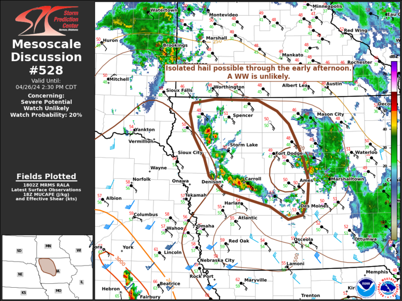
   Mesoscale Discussion 0528
   NWS Storm Prediction Center Norman OK
   0104 PM CDT Fri Apr 26 2024

   Areas affected...portions of northern and central Iowa

   Concerning...Severe potential...Watch unlikely

   Valid 261804Z - 261930Z

   Probability of Watch Issuance...20 percent

   SUMMARY...Elevated convection north of the advancing warm front may
   pose a risk for isolated hail through the early afternoon.

   DISCUSSION...As of 1800 UTC, regional radar analysis showed
   developing thunderstorms north of a warm front across pats of
   northern and central IA. Strong low-level warm advection is
   occurring ahead of the front as an upper trough begins to lift
   northeastward out of the central Plains. As broad scale ascent and
   warm advection continue, elevated buoyancy will likely support
   scattered thunderstorms. Steep mid-level lapse rates near 8 C/km and
   around 1000 J/kg of MUCAPE will support occasional strong elevated
   updrafts. Wind profiles are expected to continue to strengthen
   during the day supporting a mixed supercell/cluster mode. Large hail
   will be possible with the more robust cores above the cooler surface
   temperatures. A greater severe risk may develop later this afternoon
   as the surface layer gradually destabilizes. Given the elevated
   nature of the convection limiting coverage of stronger storms a WW
   is unlikely.

   ..Lyons/Hart.. 04/26/2024

   ...Please see www.spc.noaa.gov for graphic product...

   ATTN...WFO...DMX...FSD...OAX...

   LAT...LON   41649426 41919535 42169565 42479576 42839600 43219611
               43399605 43479553 43459452 43279410 43059383 42749365
               42449351 42099338 41739342 41499354 41429386 41649426
|
|
Top/All Mesoscale Discussions/Forecast Products/Home
|
|


 @NWSSPC