|
| Mesoscale Discussion 524 |
|
< Previous MD Next MD >
|
|
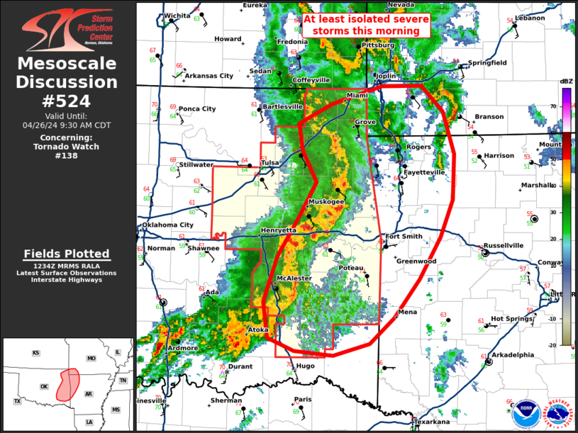
   Mesoscale Discussion 0524
   NWS Storm Prediction Center Norman OK
   0735 AM CDT Fri Apr 26 2024

   Areas affected...Eastern OK to southwest MO/western AR

   Concerning...Tornado Watch 138...

   Valid 261235Z - 261430Z

   The severe weather threat for Tornado Watch 138 continues.

   SUMMARY...Severe thunderstorms including the potential for primarily
   damaging winds and a couple tornadoes continues across eastern
   Oklahoma, and may develop into far western Arkansas and possibly
   southwest Missouri. Tornado Watch 138 continues for eastern
   Oklahoma, and downstream Arkansas/southwest Missouri areas are being
   monitored for possible but uncertain Watch issuance in the short
   term.

   DISCUSSION...A well-organized squall line with
   LEWP/northern-peripheral bowing characteristics continues across
   eastern Oklahoma, with bow-related northeastward storm motions
   around 50 kt. The most intense portion of the squall line and
   greatest short-term severe risk should be focused where the
   convective line intercepts the warm front (and just a bit north
   thereof) in the general vicinity of I-40 in far eastern Oklahoma
   into west/northwest Arkansas. Farther north, the severe-potential
   longevity of the surging bowing portion of the line is a bit more
   uncertain with northward extent, given that the bowing line will
   gradually encounter an increasingly more stable boundary layer (0.5
   km AGL deep per 12z Springfield MO observed sounding).

   ..Guyer.. 04/26/2024

   ...Please see www.spc.noaa.gov for graphic product...

   ATTN...WFO...LZK...SGF...SHV...TSA...OUN...

   LAT...LON   36019526 36629549 37029389 35829350 34309458 34369589
               35219576 36019526
|
|
Top/All Mesoscale Discussions/Forecast Products/Home
|
|


 @NWSSPC