|
| Mesoscale Discussion 499 |
|
< Previous MD Next MD >
|
|
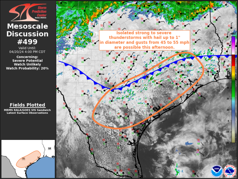
   Mesoscale Discussion 0499
   NWS Storm Prediction Center Norman OK
   0136 PM CDT Sat Apr 20 2024

   Areas affected...Texas Coastal Plain into Southeast TX

   Concerning...Severe potential...Watch unlikely

   Valid 201836Z - 202100Z

   Probability of Watch Issuance...20 percent

   SUMMARY...Widespread thunderstorms are expected from the Texas
   Coastal Plain into Southeast TX this afternoon. Isolated strong to
   severe thunderstorms are possible, with hail to 1" in diameter and
   damaging gusts from 45 to 55 mph as the primary hazards.

   DISCUSSION...A cold front continues to push slowly south across
   central and east TX, aided by a widespread showers and thunderstorms
   from southwest TX through north-central and into northeast TX. Warm
   and moist southerly low-level flow has persisted throughout the
   morning and into to early afternoon. This has resulted in increased
   low-level convergence along the front zone while also destabilizing
   the downstream air mass. Pre-frontal dewpoints now range from the
   upper 60s across the TX Hill Country to the low 70s across the TX
   Coastal Plain into southeast TX. Additionally, filtered heating has
   allowed temperatures to rise into the low 80s. These low-level
   thermodynamic conditions have resulted in air mass destabilization,
   with mesoanalysis recently estimating that convective inhibition has
   eroded. Additionally, these warm and moist conditions are
   contributing to moderate buoyancy (i.e. around 1500 J/kg) despite
   relatively poor mid-level lapse rates.

   General expectation is for thunderstorm coverage to increase this
   afternoon along and ahead of the front. Widespread coverage should
   limit storm discreteness while boundary-parallel deep-layer vertical
   shear favors multicell clusters. Even so, Given the moderate
   buoyancy and shear, a few stronger storms are possible. The
   strongest storms may be able to produce hail up to around 1". A few
   water-loaded downbursts from 45 to 55 mph are possible as well.

   ..Mosier/Goss.. 04/20/2024

   ...Please see www.spc.noaa.gov for graphic product...

   ATTN...WFO...LCH...HGX...CRP...EWX...

   LAT...LON   29299870 30079704 30809547 30609473 29759465 27989757
               28209929 29299870
|
|
Top/All Mesoscale Discussions/Forecast Products/Home
|
|


 @NWSSPC