|
| Mesoscale Discussion 498 |
|
< Previous MD Next MD >
|
|
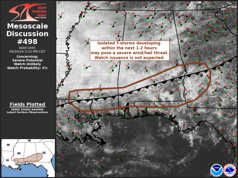
   Mesoscale Discussion 0498
   NWS Storm Prediction Center Norman OK
   0114 PM CDT Sat Apr 20 2024

   Areas affected...Southern Mississippi to southwest Georgia

   Concerning...Severe potential...Watch unlikely

   Valid 201814Z - 202015Z

   Probability of Watch Issuance...5 percent

   SUMMARY...Thunderstorms developing within the next 1-2 hours will
   pose a severe hail/wind threat through the late afternoon and
   evening hours. Watch issuance is not expected given the isolated
   nature of the threat and marginal nature of the convective
   environment.

   DISCUSSION...Several convective towers are noted in GOES day cloud
   phase RGB imagery along a cool front/surface trough draped from
   central GA to southern AL/MS. A few of the deeper convective towers
   across southwest GA and southeast AL (where inhibition is quickly
   eroding as surface temperatures climb into the 80s) have begun to
   produce lightning flashes, suggesting that more robust convective
   initiation is either underway or imminent. In general, these cells
   are developing within a marginal thermodynamic and kinematic
   environment characterized by 6-7 C/km mid-level lapse rates, MLCAPE
   on the order of 1000 J/kg, weak low-level winds, and effective bulk
   shear values between 25-30 knots (based on regional VWP observations
   and latest mesoanalyses). However, this parameter space is
   sufficient for a low-end severe hail (hail stones up to 1.25 inch
   appear possible) and wind threat - especially across southeast AL
   into southwest GA where low-level lapse rates are approaching 7-8
   C/km and may support stronger outflow winds. Initially isolated
   cells will undergo gradual upscale growth through the late
   afternoon/evening as they propagate east/southeast along the
   boundary. However, the overall severe threat is expected to remain
   sufficiently localized to preclude watch issuance.

   ..Moore/Goss.. 04/20/2024

   ...Please see www.spc.noaa.gov for graphic product...

   ATTN...WFO...FFC...TAE...BMX...MOB...JAN...LIX...

   LAT...LON   31419056 31598816 32158650 32548541 32658448 32608395
               32248370 31818372 31508389 31038449 30768540 30738625
               30778784 30648865 30548966 30509023 30699061 30899091
               31099094 31339091 31419056
|
|
Top/All Mesoscale Discussions/Forecast Products/Home
|
|


 @NWSSPC