|
| Mesoscale Discussion 493 |
|
< Previous MD Next MD >
|
|
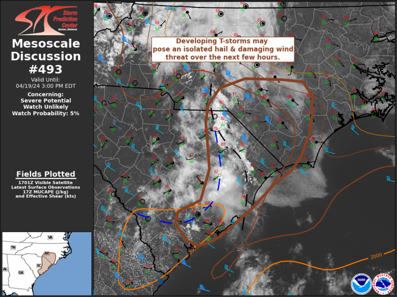
   Mesoscale Discussion 0493
   NWS Storm Prediction Center Norman OK
   1207 PM CDT Fri Apr 19 2024

   Areas affected...Eastern South Carolina into far southeast North
   Carolina

   Concerning...Severe potential...Watch unlikely

   Valid 191707Z - 191900Z

   Probability of Watch Issuance...5 percent

   SUMMARY...Thunderstorms developing off an outflow boundary and
   surface trough may intensify enough to pose a severe hail/damaging
   wind risk over the next few hours. Watch issuance is not expected
   given the localized nature of the threat.

   DISCUSSION...Deep convective initiation is underway across eastern
   SC as thunderstorms develop along an outflow boundary from
   early-morning convection. Just ahead of the outflow, deepening
   cumulus is noted along a surface trough. Additional thunderstorms
   are expected to develop across eastern SC and southeast NC within
   the next 1-2 hours as temperatures continue to warm into the low 80s
   along and downstream of these surface boundaries. Thermodynamically,
   sufficient buoyancy is evidently in place to support deep updrafts;
   however, more isolated convection has been short-lived, likely owing
   to lingering capping and modest (6-7 C/km) mid-level lapse rates.
   Longer-lived convection will likely be tied to stronger forcing
   along the outflow/trough that will most likely take on a
   clustered/linear storm mode. Regional VWP data and forecast
   hodographs show somewhat meager elongation of the deep-layer wind
   profile, but sufficient effective bulk shear (around 30-35 knots)
   should support some organization of clusters. Consequently, this
   activity may pose the threat for large hail (most likely between 0.5
   to 1.25 inch in diameter) and damaging winds - especially by the mid
   to late afternoon hours as low-level lapse rates steepen downstream
   of the developing storms.

   ..Moore/Smith.. 04/19/2024

   ...Please see www.spc.noaa.gov for graphic product...

   ATTN...WFO...MHX...RAH...ILM...CHS...CAE...

   LAT...LON   33108068 33298022 33818005 34338011 34598014 34908010
               35197986 35357934 35327857 35287816 35067796 34757796
               34397803 34007822 33797841 33557877 33157922 32917954
               32687984 32598005 32538026 32628049 32908073 33108068
|
|
Top/All Mesoscale Discussions/Forecast Products/Home
|
|


 @NWSSPC