|
| Mesoscale Discussion 494 |
|
< Previous MD
|
|
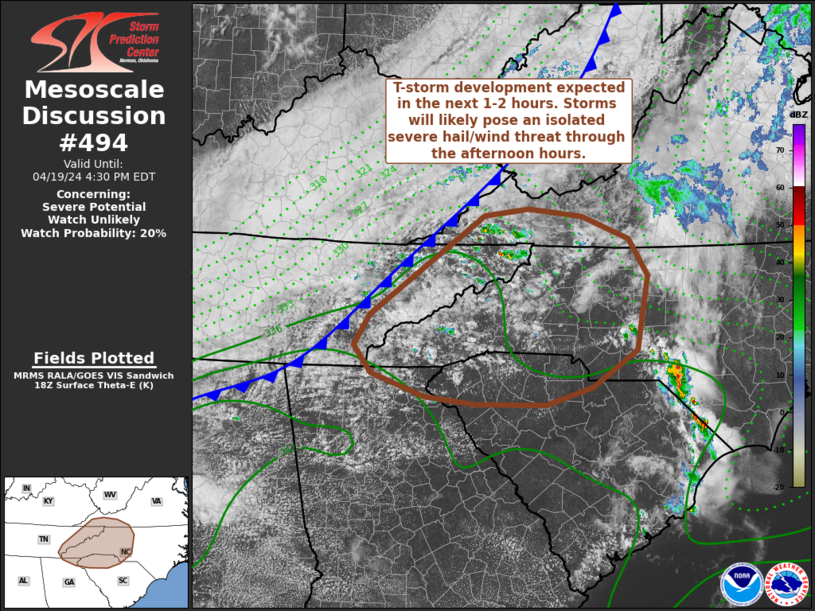
   Mesoscale Discussion 0494
   NWS Storm Prediction Center Norman OK
   0133 PM CDT Fri Apr 19 2024

   Areas affected...portions of the Tennessee Valley into the
   Mid-Atlantic

   Concerning...Severe potential...Watch unlikely

   Valid 191833Z - 192030Z

   Probability of Watch Issuance...20 percent

   SUMMARY...Thunderstorm development is anticipated in the next couple
   of hours across parts of the southern Appalachians. These storms
   should gradually intensify through the mid/late afternoon, and may
   pose a severe hail/wind threat across parts of far eastern Tennessee
   and adjacent portions of Virginia and the Carolinas. The coverage of
   strong/severe storms should be sufficiently limited to preclude
   watch issuance.

   DISCUSSION...A gradually deepening cumulus field has been tracked in
   GOES visible/IR imagery and regional radars over the past 60
   minutes. Lingering inhibition has precluded deeper convection so
   far, but continued daytime heating along with combined forcing for
   ascent along an approaching cold front and orographic lift within
   the southern Appalachians should foster more robust thunderstorms in
   the coming hours. Despite weak low-level winds, 30-40 knot flow
   aloft is supporting effective bulk shear values near 30-35 knots,
   which should be sufficient for some organization of deeper cells
   that may pose a large hail risk (most likely between 0.75 to 1.25
   inch in diameter). Additionally, heating of a somewhat dry air mass
   downstream across the Carolinas (where temperatures are climbing
   into the low 80s under clearing skies) should steepen low-level
   lapse rates by late afternoon to around 8 C/km. This may favor
   outflow-driven storms with a tendency for upscale growth into
   clusters and the potential for strong to severe gusts.

   ..Moore/Smith.. 04/19/2024

   ...Please see www.spc.noaa.gov for graphic product...

   ATTN...WFO...RAH...RNK...RLX...CAE...GSP...MRX...FFC...

   LAT...LON   36658012 36187981 35217999 34728071 34498146 34518259
               34618339 34908423 35268452 35668427 36978244 37068172
               36968086 36658012
|
|
Top/All Mesoscale Discussions/Forecast Products/Home
|
|


 @NWSSPC