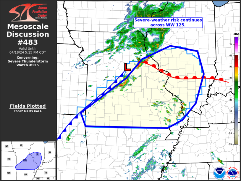
   Mesoscale Discussion 0483
   NWS Storm Prediction Center Norman OK
   0309 PM CDT Thu Apr 18 2024

   Areas affected...central and southern Missouri into southern and
   central Illinois

   Concerning...Severe Thunderstorm Watch 125...

   Valid 182009Z - 182215Z

   The severe weather threat for Severe Thunderstorm Watch 125
   continues.

   SUMMARY...Severe-weather risk continues across WW 125, particularly
   across central and into northeastern Missouri within northern
   portions of the WW.

   DISCUSSION...Latest radar loop shows a band of storms extending from
   near the Mississippi River Valley in west-central Illinois,
   southwestward into southwestern Missouri, with the strongest
   convection extending from Pike County to Morgan County Missouri --
   i.e. northeast-to-southwest through the Columbia (COU) vicinity.
   Analysis of 18Z surface data shows the surface low just north of
   COU, with the aforementioned convection along both the warm and cold
   fronts, immediately adjacent to the low.

   The strongest storm remains a now well-developed supercell storm
   just ahead of the low, over northwestern Pike County Missouri.
   Large hail, in excess of 1.5" in diameter, appears to be the main
   short-term threat with this storm.  A second storm just to the
   southwest, in Audrain County, has also strengthened over the past
   hour.

   Meanwhile, weak convection continues to increase across southeastern
   portions of the WW, over the southeastern Missouri vicinity.
   Although intensification should remain gradual, local severe risk
   should gradually increase across this area over the next 1 to 2
   hours.

   Overall, storms continue to evolve as expected, as the airmass
   continues to gradually destabilize northward into east-central
   Missouri.  Potential for large hail and locally damaging wind gusts,
   along with potential for a tornado, continues.

   ..Goss.. 04/18/2024

   ...Please see www.spc.noaa.gov for graphic product...

   ATTN...WFO...PAH...ILX...MEG...LSX...SGF...TSA...

   LAT...LON   37099487 38629246 39459161 40009005 39768855 38778823
               37538871 36838945 36499024 36529459 37099487
|


 @NWSSPC