|
| Mesoscale Discussion 482 |
|
< Previous MD Next MD >
|
|
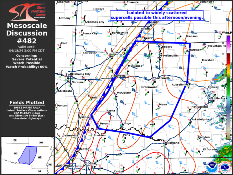
   Mesoscale Discussion 0482
   NWS Storm Prediction Center Norman OK
   0301 PM CDT Thu Apr 18 2024

   Areas affected...eastern Oklahoma and western Arkansas

   Concerning...Severe potential...Watch possible

   Valid 182001Z - 182200Z

   Probability of Watch Issuance...60 percent

   SUMMARY...Isolated to widely scattered supercells are possible this
   afternoon/evening.

   DISCUSSION...A strong cold front continues to move rapidly across
   Oklahoma this afternoon. Temperatures ahead of the front have warmed
   into the upper 70s to near 80 across eastern Oklahoma with a moist
   airmass featuring dewpoints in the upper 60s to low 70s. This yields
   over 2500 J/kg MLCAPE and effective shear around 40 to 45 knots.
   This parameter space is quite favorable for supercells capable of
   large to very large hail if storms form. However, there is
   considerable uncertainty regarding convective coverage this
   afternoon/evening. Despite strong convergence along the front in
   northeast Oklahoma, updrafts have struggled to deepen sufficiently
   to produce lightning. KINX base reflectivity indicates this is most
   likely due to storms struggling to stay anchored to, or ahead of,
   the cold front in the warm air. Stronger mid-level flow, the arrival
   of which likely coincides with mid-upper level cirrus moving across
   western Oklahoma now, may assist in storms remaining along or ahead
   of the front later this afternoon. Therefore, anticipate storms may
   struggle for the next 1 to 2 hours before a better chance of a few
   strong to severe supercells occurs later this afternoon/evening with
   the arrival of this mid-level speed max.

   ..Bentley/Mosier.. 04/18/2024

   ...Please see www.spc.noaa.gov for graphic product...

   ATTN...WFO...LZK...SGF...SHV...TSA...FWD...OUN...

   LAT...LON   36209306 35319317 34159382 33649456 33789532 33909642
               34319669 34989611 35799563 36569507 36489303 36209306
|
|
Top/All Mesoscale Discussions/Forecast Products/Home
|
|


 @NWSSPC