|
| Mesoscale Discussion 457 |
|
< Previous MD Next MD >
|
|
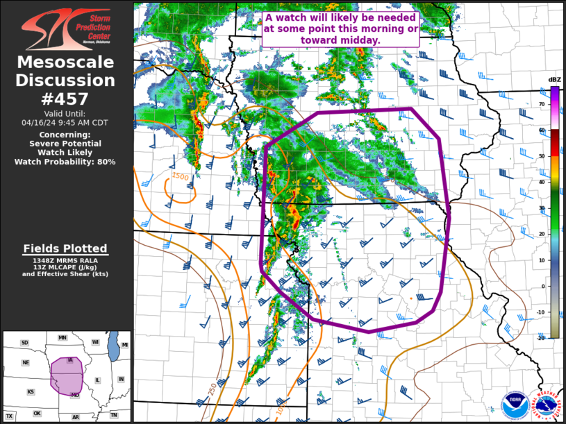
   Mesoscale Discussion 0457
   NWS Storm Prediction Center Norman OK
   0850 AM CDT Tue Apr 16 2024

   Areas affected...portions of IA into northern MO

   Concerning...Severe potential...Watch likely

   Valid 161350Z - 161445Z

   Probability of Watch Issuance...80 percent

   SUMMARY...Thunderstorms ongoing across far eastern Kansas into
   northwest Missouri will likely continue to shift northeast through
   the morning. Severe potential may increase gradually through the
   morning downstream across northern Missouri and southern Iowa. Area
   being monitored for watch issuance.

   DISCUSSION...Thunderstorms tracking northeast across eastern
   KS/northwest MO ahead of a surface cold front are expected to
   continue through the morning. The downstream airmass remains at
   least weakly capped given cloud cover and limited heating. Ongoing
   activity is likely sub-severe at this point, though may produce
   gusty winds 40-50 mph given recent obs of 41 kt at STJ and 39 kt at
   EVU. With time and additional destabilization, convection may
   intensify and become severe, though the northern extent of
   convection will also be outpacing higher-quality moisture/warmer
   temperatures as storms lift northeast into IA (surface dewpoints in
   the 50s F). Additional convection is expected to develop with
   southward extent into northern MO. This area is currently
   experiencing somewhat better heating through broken cloudiness. This
   may allow for greater destabilization given better boundary-layer
   moisture.

   The overall expectation is that a line of storms will develop north
   to south across IA into northern MO through the morning. This
   activity will have potential to produce severe gusts and a couple of
   tornadoes. Additional severe potential may develop later this
   afternoon in the wake of this initial morning activity if airmass
   recovery can occur. A watch will likely be needed in the next hour
   or so.

   ..Leitman/Guyer.. 04/16/2024

   ...Please see www.spc.noaa.gov for graphic product...

   ATTN...WFO...LSX...DVN...SGF...DMX...EAX...OAX...TOP...

   LAT...LON   39509570 41579564 42179444 42249224 41719159 40309139
               39009163 38689181 38489220 38319326 38539450 39019524
               39379568 39509570
|
|
Top/All Mesoscale Discussions/Forecast Products/Home
|
|


 @NWSSPC