|
| Mesoscale Discussion 458 |
|
< Previous MD Next MD >
|
|
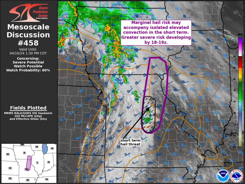
   Mesoscale Discussion 0458
   NWS Storm Prediction Center Norman OK
   1104 AM CDT Tue Apr 16 2024

   Areas affected...central and northeast MO into southeast IA and far
   west-central IL

   Concerning...Severe potential...Watch possible

   Valid 161604Z - 161830Z

   Probability of Watch Issuance...60 percent

   SUMMARY...An isolated hail risk may persist for a couple of hours
   across central Missouri. With time, severe potential is expected to
   increase from northeast Missouri into southeast Iowa. A watch will
   likely be needed in the next few hours, but timing is uncertain.

   DISCUSSION...Elevated convection developing across central Missouri
   may initially pose a marginally severe hail risk over the next 1-2
   hours. Moderate to strong MLCINH is still apparent from central MO
   into southeast IA late this morning, stronger heating is underway
   amid broken cloudiness. Temperatures have warmed into the low to mid
   70s F amid low 60s F dewpoints, resulting in modest destabilization.
   With continued heating and eastward progression of large-scale
   ascent impinging on the area by early afternoon, capping should
   sufficiently erode such that severe potential will gradually
   increase over the next few hours. Quite a bit of uncertainty still
   exists in the exact evolution of storms given areas of ongoing
   convection and cloud cover. Additionally, more than one round of
   storms appears possible for parts of the region. Altogether, this is
   resulting in uncertainty in timing of watch issuance. Trends will
   continue to be monitored for watch issuance within the next few
   hours.

   ..Leitman/Guyer.. 04/16/2024

   ...Please see www.spc.noaa.gov for graphic product...

   ATTN...WFO...LSX...DVN...SGF...DMX...EAX...

   LAT...LON   38239256 38559261 39409252 41329215 41339161 41139124
               40619112 39819118 38689150 38259165 38039201 38039233
               38119243 38239256
|
|
Top/All Mesoscale Discussions/Forecast Products/Home
|
|


 @NWSSPC