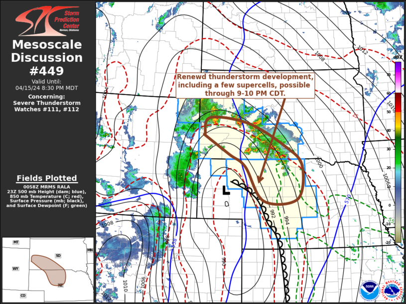
   Mesoscale Discussion 0449
   NWS Storm Prediction Center Norman OK
   0800 PM CDT Mon Apr 15 2024

   Areas affected...southwestern South Dakota into north central
   Nebraska

   Concerning...Severe Thunderstorm Watch 111...112...

   Valid 160100Z - 160230Z

   The severe weather threat for Severe Thunderstorm Watch 111, 112
   continues.

   SUMMARY...Initial thunderstorm development probably will weaken
   while spreading toward northwestern/north central South Dakota, with
   renewed thunderstorm development, including potential for a few
   supercells, north of North Platte toward the Mullen vicinity through
   9-10 PM CDT.

   DISCUSSION...Beneath a focused area of divergent upper flow,
   downstream of the mid-level low migrating northeast of the Four
   Corners, thunderstorms have become numerous within a corridor of
   lower/mid-tropospheric warm advection.  This appears to be gradually
   spreading to the north of the corridor of the better boundary-layer
   moisture wrapping toward an initial surface low center over the
   Nebraska Panhandle.  As this continues, this initial thunderstorm
   activity seems likely to weaken as it ingests drier and more stable
   air.  However, the environment remains favorable for renewed strong
   to severe thunderstorm development, including supercells, within a
   corridor northeast of North Platte toward Mullen NE, which will tend
   to move northward/northeastward through late evening.

   ..Kerr.. 04/16/2024

   ...Please see www.spc.noaa.gov for graphic product...

   ATTN...WFO...ABR...LBF...UNR...

   LAT...LON   44360356 44190177 43400007 42769935 41669958 41600111
               42750193 43150265 43800381 43790378 44360356
|


 @NWSSPC