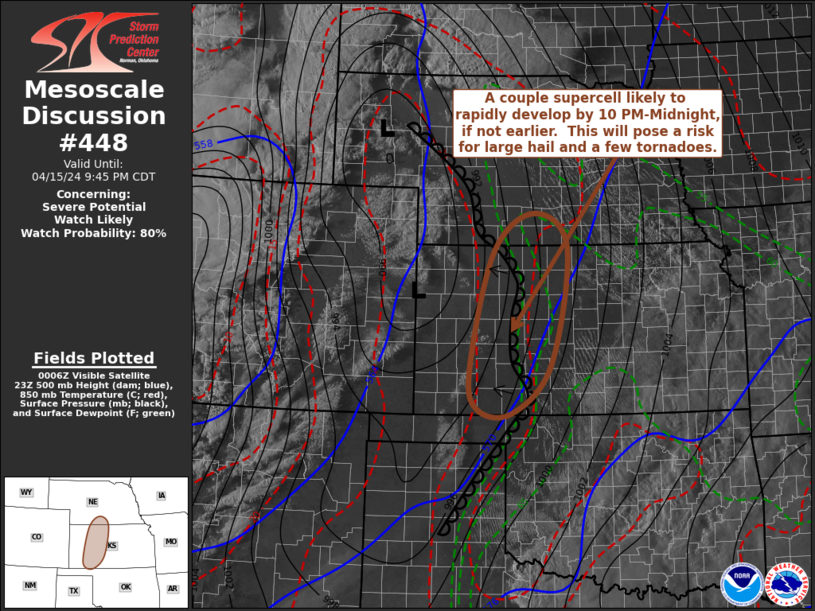
   Mesoscale Discussion 0448
   NWS Storm Prediction Center Norman OK
   0713 PM CDT Mon Apr 15 2024

   Areas affected...parts of western/central Kansas into south central
   Nebraska

   Concerning...Severe potential...Watch likely

   Valid 160013Z - 160245Z

   Probability of Watch Issuance...80 percent

   SUMMARY...Rapid thunderstorm development and intensification appears
   probable at some point this evening, most likely by 10 PM-Midnight,
   but perhaps an hour or two earlier.  Once storms form, a few
   supercells  are likely posing a risk for large hail and tornadoes, a
   couple of which could become strong. Trends are closely being
   monitored for a watch issuance, which seems likely at some point,
   though timing remains a bit unclear.

   DISCUSSION...A significant mid-level trough and embedded low are in
   the process of overspreading the the southern Rockies, with the
   leading edge of stronger mid-level height falls beginning to impact
   the high plains from the Texas Panhandle through the Black Hills
   vicinity.  As intensifying southwesterly mid-level flow (in excess
   of 90 kt around 500 mb) noses across the Texas Panhandle vicinity
   through 02-04Z, strengthening mid/upper forcing for ascent likely
   will increasingly interact with a retreating dryline across western
   Kansas.

   As boundary-layer moisture, characterized by dew points increasing
   as high as the lower/mid 60s, advects westward beneath steepening
   lapse rates aided by cooling aloft, forecast soundings suggest
   mixed-layer CAPE may increase in excess of 2000 J/kg within at least
   a narrow corridor.  By mid to late evening, it appears that this
   will roughly become focused along an axis from near Dodge City  KS
   into areas west of Kearney NE.

   Some increase in high based convective development is already
   evident to the west of the dryline across the Texas Panhandle into
   western Kansas.  While guidance has generally been suggestive that
   more substantive convective development and thunderstorm initiation
   may not commence until closer to the 03-05Z time frame, it is not
   certain that this will not occur sooner.  Of primary concern, once
   storms initiate, intensification may be rapid and include at least
   one or two supercells with potential to produce strong tornadoes, as
   boundary-layer moistening and destabilization coincide with
   enlarging clockwise-curved hodographs beneath southerly 850 mb flow
   strengthening in excess of 50 kt.

   ..Kerr/Thompson.. 04/16/2024

   ...Please see www.spc.noaa.gov for graphic product...

   ATTN...WFO...ICT...GID...DDC...GLD...

   LAT...LON   37830081 39880027 40579936 39959859 37869899 37019987
               37090065 37830081
|


 @NWSSPC