|
| Mesoscale Discussion 443 |
|
< Previous MD Next MD >
|
|
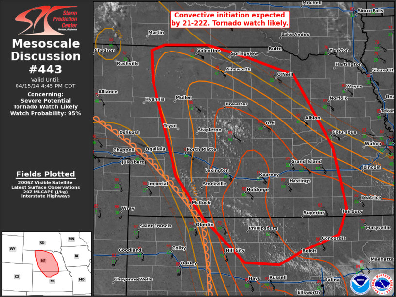
   Mesoscale Discussion 0443
   NWS Storm Prediction Center Norman OK
   0313 PM CDT Mon Apr 15 2024

   Areas affected...central Nebraska into far northern Kansas

   Concerning...Severe potential...Tornado Watch likely

   Valid 152013Z - 152145Z

   Probability of Watch Issuance...95 percent

   SUMMARY...Convective initiation is expected by 21-22Z. A tornado
   watch is likely.

   DISCUSSION...Robust destabilization is underway across the Plains
   with rapid moisture advection occurring across Nebraska. Low 60s
   dewpoints are now into southern Nebraska with mid 60s dewpoints
   across much of central and eastern Kansas. SPC mesoanalysis shows
   inhibition has now mostly eroded across this region and the
   aforementioned moisture advection, combined with broad scale ascent
   ahead of the primary trough, should allow for convective initiation
   within the next 2 hours. Almost all WoFS members show isolated
   thunderstorms forming between 21Z and 22Z.

   Strong veering wind profiles and strong instability will support
   supercells as the storm mode. However, storms should remain fairly
   isolated this afternoon and early evening due to the limited
   forcing. During the afternoon/early evening, large hail and severe
   wind gusts will be possible. The low-level wind profile will be
   favorable for tornadoes, but limited moisture may hinder this threat
   during the afternoon period.

   During the late evening and overnight hours. Increasing moisture and
   ascent should lead to more widespread convection and a greater
   tornado threat. Particularly as the low-level jet intensifies after
   sunset.

   ..Bentley/Smith.. 04/15/2024

   ...Please see www.spc.noaa.gov for graphic product...

   ATTN...WFO...OAX...TOP...GID...LBF...UNR...GLD...

   LAT...LON   39169861 39219938 39990035 40710098 42370156 42910160
               43010129 43020027 42819931 42509824 41219733 40159704
               39679724 39419807 39169861
|
|
Top/All Mesoscale Discussions/Forecast Products/Home
|
|


 @NWSSPC