|
| Mesoscale Discussion 442 |
|
< Previous MD Next MD >
|
|
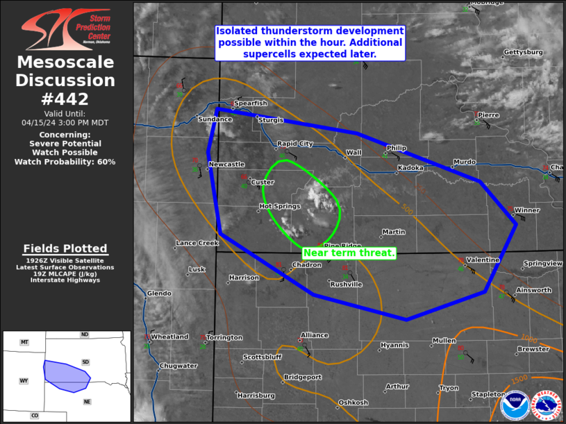
   Mesoscale Discussion 0442
   NWS Storm Prediction Center Norman OK
   0230 PM CDT Mon Apr 15 2024

   Areas affected...Southwest South Dakota and far northern Nebraska.

   Concerning...Severe potential...Watch possible

   Valid 151930Z - 152100Z

   Probability of Watch Issuance...60 percent

   SUMMARY...Isolated thunderstorms development is possible within the
   hour across southwest South Dakota. Additional supercell development
   is expected later this afternoon.

   DISCUSSION...Temperatures have warmed into the low 80s across
   southwest South Dakota which, despite the dry airmass, has led to
   moderate destabilization. Visible satellite shows a few cumulus
   clusters near the Badlands, moving northwest. Most CAM guidance
   suggests storm development much later this afternoon/early evening,
   but satellite trends suggest convective initiation may occur within
   the next hour.

   If isolated severe storms develop, a severe thunderstorm watch may
   be needed soon. Otherwise, a watch is more likely late this
   afternoon/early evening when stronger lift overspreads the region
   and more widespread thunderstorm development occurs. Strongly veered
   wind profiles will support supercell storm mode with large hail, and
   given the nearly 50 degree dewpoint depressions and inverted-V
   soundings, severe wind gusts will also be possible.

   ..Bentley/Smith.. 04/15/2024

   ...Please see www.spc.noaa.gov for graphic product...

   ATTN...WFO...ABR...LBF...UNR...CYS...

   LAT...LON   43180400 44020420 44470407 44230206 43730031 43289982
               42590027 42310137 42570268 43180400
|
|
Top/All Mesoscale Discussions/Forecast Products/Home
|
|


 @NWSSPC