|
| Mesoscale Discussion 435 |
|
< Previous MD Next MD >
|
|
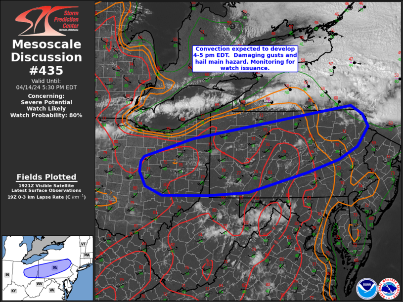
   Mesoscale Discussion 0435
   NWS Storm Prediction Center Norman OK
   0229 PM CDT Sun Apr 14 2024

   Areas affected...portions of central/eastern Ohio into Pennsylvania

   Concerning...Severe potential...Watch likely

   Valid 141929Z - 142130Z

   Probability of Watch Issuance...80 percent

   SUMMARY...Thunderstorms are expected to develop by 4-5 pm EDT.
   Damaging gusts and isolated large hail will the the main hazards
   with this activity as storms track south-southeast through the
   evening. A severe thunderstorm watch will likely by needed in the
   next 1-2 hours.

   DISCUSSION...Boundary-layer moisture has gradually increased through
   the day across the Upper Ohio Valley into northeast PA, with surface
   dewpoints now in the mid 40s to low 50s F. Strong heating beneath
   steep lapse rates is supporting weak destabilization. Deepening
   cumulus has been noted over Lake Erie into western NY the past hour
   or so, indicating increasing ascent is overspreading the region. The
   expectation is that this activity will continue to deepen and
   potentially become more surface-based with time as it shifts
   southward into OH/PA over the next few hours.

   Initial cells will likely quickly develop into linear segments given
   unidirectional flow, which is also parallel to a
   south/southeastward-advancing surface cold front. Given steep
   low-level lapse rates and modest boundary-layer moisture, damaging
   gusts are expected. Furthermore, steep midlevel lapse rates and cold
   temperatures aloft will support isolated large hail, especially with
   any convection that remains cellular/semi-discrete. Some improvement
   of low-level shear is expected with time, resulting in somewhat
   enlarged low-level hodographs. This may support a tornado or two,
   but marginal low-level moisture will limit the overall tornado risk.

   ..Leitman/Smith.. 04/14/2024

   ...Please see www.spc.noaa.gov for graphic product...

   ATTN...WFO...PHI...BGM...CTP...PBZ...RLX...CLE...ILN...

   LAT...LON   40768277 41258110 41947686 42107557 41887519 41547500
               41027539 40697604 40377712 39857919 39768057 39748213
               39978271 40358292 40638290 40768277
|
|
Top/All Mesoscale Discussions/Forecast Products/Home
|
|


 @NWSSPC