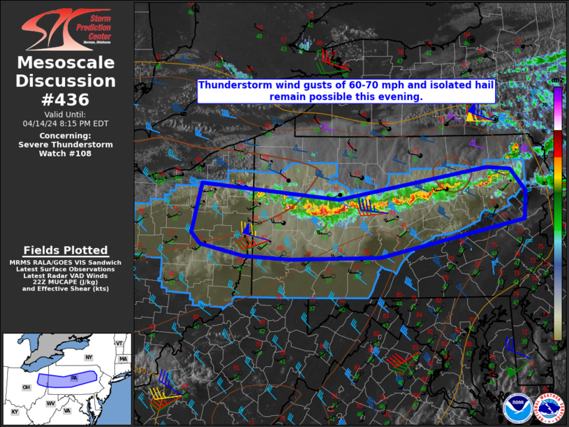
   Mesoscale Discussion 0436
   NWS Storm Prediction Center Norman OK
   0546 PM CDT Sun Apr 14 2024

   Areas affected...Eastern OH into much of PA

   Concerning...Severe Thunderstorm Watch 108...

   Valid 142246Z - 150015Z

   The severe weather threat for Severe Thunderstorm Watch 108
   continues.

   SUMMARY...Thunderstorm wind gusts of 60-70 mph and isolated severe
   hail remain possible this evening.

   DISCUSSION...Despite limited low-level moisture, seasonably strong
   diurnal heating beneath cold temperatures aloft has resulted in the
   development of extensive deep convection from northeast OH into much
   of northern PA. The strongest storms are ongoing this evening across
   western PA, where somewhat more favorable low-level moisture
   (coincident with a cumulus field across northeast OH) is feeding in
   from the west. A 68 mph gust at KYNG was noted earlier, and a
   combination of relatively strong low-level flow and a deep,
   well-mixed boundary later will continue to support a threat of wind
   gusts of up to 60-70 mph through early evening. Steep lapse rates
   will continue to support an isolated hail threat, especially with
   storms ongoing along the western end of the ongoing QLCS, where
   somewhat greater instability in place and there will be less of a
   tendency for storm interference. Some backbuilding into eastern OH
   will be possible over the next 1-2 hours, before nocturnal
   cooling/stabilization begins to diminish the threat.

   Farther east into central/eastern PA, instability is somewhat
   weaker, but a threat for damaging winds will accompany the strongest
   storms, especially in areas where stronger heating/mixing occurred
   earlier today. A gradual weakening trend is expected later this
   evening, but some threat for localized damaging winds will persist
   for as long as vigorous convection (and its related outflow) can be
   sustained as it moves east-southeastward. Depending on convective
   trends, local extension of WW 108 may be needed, but additional
   downstream watch issuance currently appears unlikely.

   ..Dean.. 04/14/2024

   ...Please see www.spc.noaa.gov for graphic product...

   ATTN...WFO...PHI...BGM...CTP...PBZ...CLE...

   LAT...LON   41318148 41117892 41547615 41527572 41217543 40807547
               40297815 40257981 40308068 40468149 40618165 41318148
|


 @NWSSPC