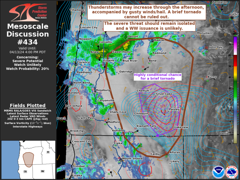
   Mesoscale Discussion 0434
   NWS Storm Prediction Center Norman OK
   0325 PM CDT Sat Apr 13 2024

   Areas affected...portions of extreme northern California into
   central Oregon

   Concerning...Severe potential...Watch unlikely

   Valid 132025Z - 132300Z

   Probability of Watch Issuance...20 percent

   SUMMARY...Thunderstorms are expected to gradually increase in both
   coverage and intensity through the afternoon. Hail and strong wind
   gusts will be the main threats, though a brief tornado cannot be
   completely ruled out. The severe threat should remain isolated and a
   WW issuance is not expected.

   DISCUSSION...Despite limited surface heating, increasing deep-layer
   ascent, driven by the approach of a mid-level jet streak, is
   contributing to a gradual increase in thunderstorm coverage across
   parts of southern OR/northern CA. Temperatures are warming into the
   mid 50s F, with dewpoints near 40 F in place, supporting around 1000
   J/kg SBCAPE, but under 500 J/kg of MLCAPE. Given widespread clouds
   in place, the boundary layer remains moist, but also cool, with the
   aforementioned CAPE constrained to short and narrow profiles (per
   19Z RAP forecast soundings) despite steep tropospheric lapse rates
   in place. Shear profiles favor some severe potential, with forecast
   soundings showing curved and elongated hodographs, with up to 50 kts
   of effective bulk shear in place. As such, multicells and supercells
   should be the primary mode of convection, with gusty winds and hail
   the main threats.

   A brief tornado also cannot be ruled out, especially to the
   immediate lee of the southern Cascades, where 20Z mesoanalysis
   depicts a local maxima in low-level vertical vorticity coinciding
   with over 100 J/kg of 0-3 km CAPE. Any supercell that manages to
   develop and traverse this local corridor may stretch the vorticity
   and spawn a brief landspout/supercell hybrid tornado, though this
   scenario remains highly conditional. Furthermore, the overall severe
   threat is expected to remain isolated and a WW issuance is not
   anticipated.

   ..Squitieri/Leitman.. 04/13/2024

   ...Please see www.spc.noaa.gov for graphic product...

   ATTN...WFO...BOI...PDT...MFR...PQR...

   LAT...LON   41392088 41442137 41572172 41962219 42292234 43162272
               43782296 44272288 44682207 44752089 44592016 44331969
               44191956 43271975 42671993 42022009 41532055 41392088
|


 @NWSSPC