|
| Mesoscale Discussion 433 |
|
< Previous MD Next MD >
|
|
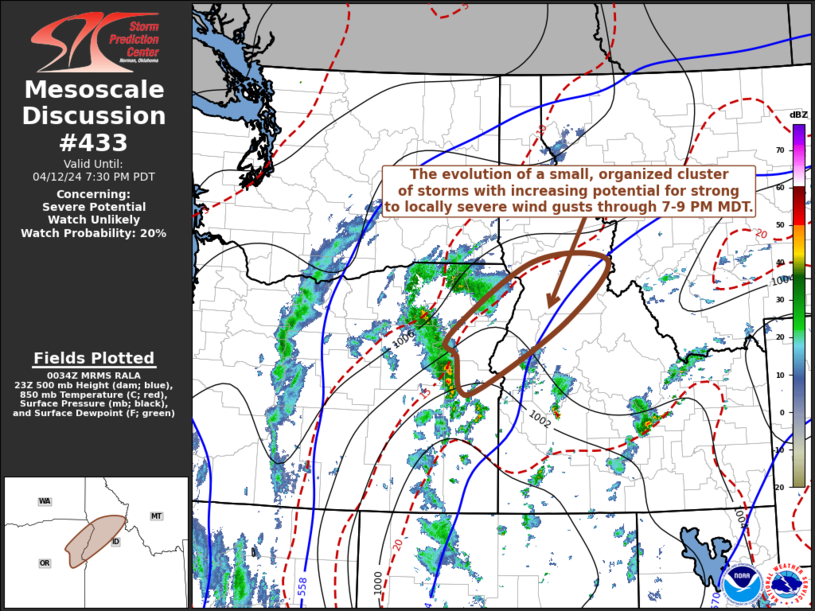
   Mesoscale Discussion 0433
   NWS Storm Prediction Center Norman OK
   0736 PM CDT Fri Apr 12 2024

   Areas affected...parts of northeastern Oregon into north central
   Idaha

   Concerning...Severe potential...Watch unlikely

   Valid 130036Z - 130230Z

   Probability of Watch Issuance...20 percent

   SUMMARY...A small cluster of thunderstorms may continue to evolve
   and organize near and east-northeast of the Baker OR vicinity, with
   increasing potential to produce strong to severe wind gusts while
   spreading toward the Bitterroot and Salmon River Mountains vicinity
   through 7-9 PM MDT.

   DISCUSSION...Thunderstorm development has recently intensified in a
   narrow line near/south of the Blue Mountains vicinity of
   northeastern Oregon.  This appears aided by a focused area of
   large-scale ascent supported by low-level warm advection, beneath a
   difluent and divergent upper flow regime.   As a high-level jet
   streak continues to propagate eastward to the north of the western
   Canadian/U.S. border vicinity, this forcing is forecast to generally
   shift east-northeastward into parts of the Salmon River Mountains
   and Bitterroot Range of north central Idaho.

   Although peak late afternoon instability appears characterized by
   relatively modest CAPE on the order of 500 J/kg, strong deep layer
   shear (50+ kt) may contribute further intensification of convection
   during the next few hours.  The evolution of a small, but
   increasingly organized cluster of storms appears possible, which may
   gradually be accompanied by strengthening rear inflow and perhaps
   increasing potential for strong to severe gusts to reach the
   surface, aided by relatively dry sub-cloud air with modestly steep
   lapse rates.

   ..Kerr/Thompson.. 04/13/2024

   ...Please see www.spc.noaa.gov for graphic product...

   ATTN...WFO...MSO...BOI...PDT...

   LAT...LON   44841815 46031625 46041454 45081549 44021738 43971789
               44521796 44841815
|
|
Top/All Mesoscale Discussions/Forecast Products/Home
|
|


 @NWSSPC