|
| Mesoscale Discussion 432 |
|
< Previous MD Next MD >
|
|
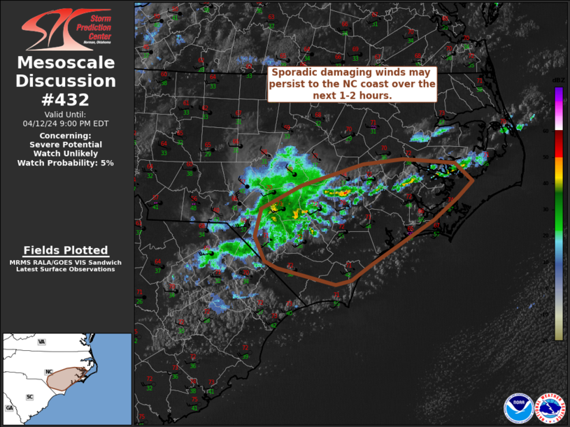
   Mesoscale Discussion 0432
   NWS Storm Prediction Center Norman OK
   0556 PM CDT Fri Apr 12 2024

   Areas affected...Southeast North Carolina

   Concerning...Severe potential...Watch unlikely

   Valid 122256Z - 130100Z

   Probability of Watch Issuance...5 percent

   SUMMARY...Weak convection will pose a damaging wind risk over the
   next 1-2 hours as storms approach the southeastern North Carolina
   coast. Watch issuance is not expected.

   DISCUSSION...Weak, shallow convection migrating eastward across
   southern NC has persisted over the past 1-2 hours despite a very
   marginal thermodynamic environment (MLCAPE generally near 250 J/kg
   or less per recent mesoanalyses and forecast soundings). This
   persistence is likely attributable to lift ahead of a subtle
   vorticity maximum. Despite the poor buoyancy, low-level warming has
   resulted in steep boundary-layer lapse rates up to 7-8 C/km, which
   is facilitating downward transfer of stronger mid-level flow.
   Surface observations have reported isolated severe winds (59 mph was
   recently measured at KFAY), with more frequent gusts around 35-50
   mph. While severe winds will likely be confined to very narrow
   swaths, the relatively more widespread 35-50 mph winds will pose a
   wind damage risk. The onset of nocturnal cooling in the coming hours
   will further limit convective intensity and should hinder efficient
   mixing, but favorable forcing for ascent may maintain poorly
   organized convection (and associated damaging wind threat) to the NC
   coast.

   ..Moore/Thompson.. 04/12/2024

   ...Please see www.spc.noaa.gov for graphic product...

   ATTN...WFO...MHX...RAH...ILM...

   LAT...LON   34377914 34667927 34977919 35247862 35497776 35557718
               35517645 35307620 35117641 34847676 34567724 34347762
               34147791 34107814 34287895 34377914
|
|
Top/All Mesoscale Discussions/Forecast Products/Home
|
|


 @NWSSPC