|
| Mesoscale Discussion 431 |
|
< Previous MD Next MD >
|
|
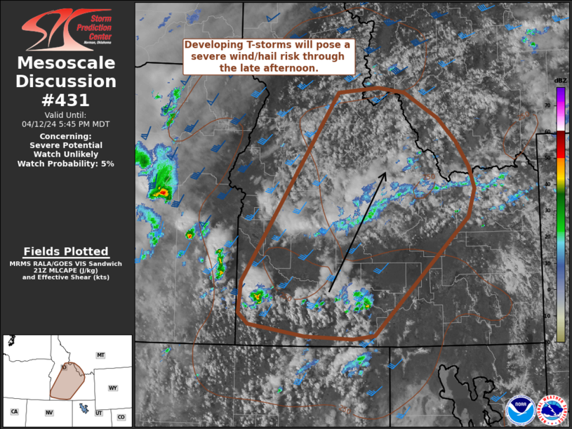
   Mesoscale Discussion 0431
   NWS Storm Prediction Center Norman OK
   0442 PM CDT Fri Apr 12 2024

   Areas affected...Idaho into far southwest Montana

   Concerning...Severe potential...Watch unlikely

   Valid 122142Z - 122345Z

   Probability of Watch Issuance...5 percent

   SUMMARY...Developing thunderstorms across southern Idaho are
   expected to pose a severe wind and hail risk through the late
   afternoon hours as they spread northeast into central Idaho and far
   southwest Montana. Watch issuance is unlikely given the localized
   nature of the threat and somewhat marginal environment.

   DISCUSSION...Latest GOES visible and IR imagery show a cluster of
   steadily deepening cumulus across south-central ID. This is likely
   in response to a combination of quickly eroding MLCIN and increasing
   ascent ahead of a mid-level wave approaching from the
   south/southwest. Deep boundary-layer mixing is limiting buoyancy
   with MLCAPE values generally between 250-500 J/kg; however, this has
   resulted in 0-3 km lapse rates between 8-9 C/km, which will support
   the potential for strong to severe downburst winds with deeper
   convective cells. This potential will likely be maximized across
   areas where temperatures have warmed into the mid/upper 70s. 30-40
   knot mid-level winds are elongating mid-level hodographs enough to
   support effective bulk shear values around 30-35 knots. This
   kinematic environment, combined with steep mid-level lapse rates,
   may allow for a supercell or two that will pose a severe hail risk
   (though this scenario is less certain given the modest buoyancy).
   The marginal nature of the buoyancy field and weak/nebulous forcing
   for ascent should limit the overall extent of the severe threat as
   storms spread north/northeast.

   ..Moore/Thompson.. 04/12/2024

   ...Please see www.spc.noaa.gov for graphic product...

   ATTN...WFO...TFX...PIH...MSO...BOI...

   LAT...LON   42091474 42131568 42301679 42471699 42911693 45631503
               45711423 45631372 45271304 44931268 44571244 44261232
               43851245 42141432 42091474
|
|
Top/All Mesoscale Discussions/Forecast Products/Home
|
|


 @NWSSPC