|
| Mesoscale Discussion 430 |
|
< Previous MD Next MD >
|
|
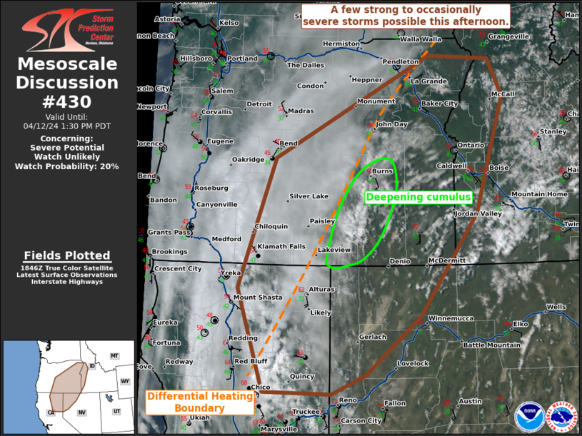
   Mesoscale Discussion 0430
   NWS Storm Prediction Center Norman OK
   0153 PM CDT Fri Apr 12 2024

   Areas affected...Northeast California...Eastern Oregon...far Western
   Idaho...and northwest Nevada

   Concerning...Severe potential...Watch unlikely

   Valid 121853Z - 122030Z

   Probability of Watch Issuance...20 percent

   SUMMARY...A few strong to occasionally severe storms are possible
   this afternoon from northeast California into eastern Oregon and
   western Idaho.

   DISCUSSION...Thunderstorms have developed amid weak instability
   across the higher terrain in northeast California. Additional
   development is apparent on visible satellite along a differential
   heating boundary along the edge of the mid-level cloud deck across
   portions of eastern Oregon. Instability remains quite weak at this
   time with temperatures only in the 60s. However, temperatures are
   expected to warm into the upper 60s to low 70s with MLCAPE around
   250 to 500 J/kg by later this afternoon. This, combined with around
   25 to 30 knots of effective shear, should be sufficient for some
   organized storms this afternoon. Forecast soundings show very deep
   mixing (to near 500mb) which will support some severe wind threat.
   The hail threat will be mostly across eastern Oregon and western
   Idaho where greater instability and somewhat stronger shear are
   expected later this afternoon. Given the expectation for isolated
   coverage of severe storms, no watch is anticipated.

   ..Bentley/Goss.. 04/12/2024

   ...Please see www.spc.noaa.gov for graphic product...

   ATTN...WFO...MSO...BOI...LKN...PDT...REV...MFR...STO...

   LAT...LON   39742155 41572219 43892133 45701760 45631615 44971581
               42901648 41081785 40051915 39711995 39742155
|
|
Top/All Mesoscale Discussions/Forecast Products/Home
|
|


 @NWSSPC