|
| Mesoscale Discussion 304 |
|
< Previous MD Next MD >
|
|
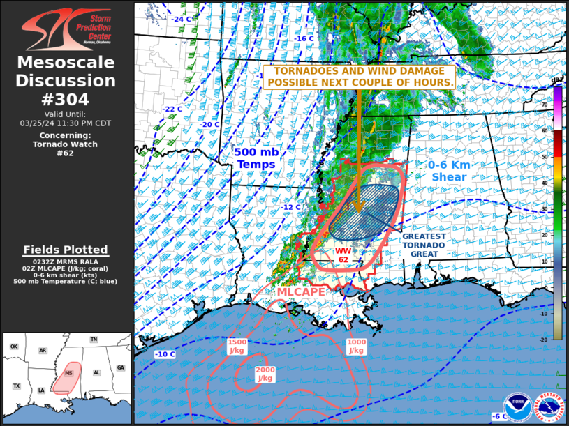
   Mesoscale Discussion 0304
   NWS Storm Prediction Center Norman OK
   0935 PM CDT Mon Mar 25 2024

   Areas affected...Southern and Central Mississippi...Far Eastern
   Louisiana

   Concerning...Tornado Watch 62...

   Valid 260235Z - 260430Z

   The severe weather threat for Tornado Watch 62 continues.

   SUMMARY...A threat for tornadoes and wind damage will likely
   continue over the next couple of hours across Tornado Watch  62.

   DISCUSSION...The latest high-resolution radar imagery from Jackson,
   MS shows an organized line of strong thunderstorms located across
   southwest and central Mississippi. This line of storms is located in
   weak instability along an axis of maximized low-level moisture with
   surface dewpoints from 65 to 70 F. On the large-scale, an 80 to 100
   knot mid-level jet is passing through the Ark-La-Tex. Large-scale
   ascent associated with this feature is helping to support and
   intensify the line. In addition, the latest WSR-88D VWP from
   Jackson, MS has an impressive shear profile, with an increase to 65
   knots in the lowest 1 km, and a large looping hodograph. This will
   likely support a tornado threat with embedded rotating cells within
   the line. The greatest threat will likely be in central Mississippi,
   where the combination of shear and lift appears to be maximized.
   Wind damage will also be possible ahead of the more intense line
   segments.

   ..Broyles.. 03/26/2024

   ...Please see www.spc.noaa.gov for graphic product...

   ATTN...WFO...MOB...JAN...LIX...

   LAT...LON   30749019 30848963 31308920 32178868 32878845 33328841
               33578862 33638900 33638939 33528969 33178998 32669032
               32049084 31499123 31189135 30849115 30759089 30749019
|
|
Top/All Mesoscale Discussions/Forecast Products/Home
|
|


 @NWSSPC