|
| Mesoscale Discussion 59 |
|
< Previous MD Next MD >
|
|
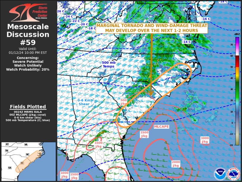
   Mesoscale Discussion 0059
   NWS Storm Prediction Center Norman OK
   0627 PM CST Fri Jan 12 2024

   Areas affected...Eastern Georgia...Eastern South Carolina and
   eastern North Carolina

   Concerning...Severe potential...Watch unlikely

   Valid 130027Z - 130300Z

   Probability of Watch Issuance...20 percent

   SUMMARY...A marginal severe threat may develop across parts of far
   eastern Georgia, eastern South Carolina and eastern North Carolina
   over the next 1 to 2 hours. No weather watch issuance is expected.

   DISCUSSION...The latest radar imagery shows a band of convection
   oriented from south-southwest to north-northeast from southern
   Georgia to central North Carolina. This convection is located along
   the northern edge of a weakly unstable airmass, where the RAP is
   analyzing MLCAPE below 500 J/kg. In spite of the weak instability,
   moisture advection will occur across the eastern Carolinas over the
   next couple of hours, which will result in a gradually increase in
   instability. In addition, regional WSR-88D VWPs in the eastern
   Carolinas have very strong deep-layer shear, associated with the
   eastern edge of a broad mid-level jet. For this reason, there will
   be potential for weakly organized rotating storms. Although a weak
   tornado or strong wind gust will be possible, the threat should
   remain isolated as the upper-level system over the Northeast pulls
   away from the region.

   ..Broyles/Goss.. 01/13/2024

   ...Please see www.spc.noaa.gov for graphic product...

   ATTN...WFO...AKQ...MHX...RAH...ILM...CHS...CAE...

   LAT...LON   32987960 33807852 34557718 35057642 35467626 35817655
               35927717 35697769 34877907 33278130 32628187 32228190
               31918151 32028085 32987960
|
|
Top/All Mesoscale Discussions/Forecast Products/Home
|
|


 @NWSSPC