|
| Mesoscale Discussion 58 |
|
< Previous MD Next MD >
|
|
Mesoscale Discussion 0058
NWS Storm Prediction Center Norman OK
0547 PM CST Fri Jan 12 2024
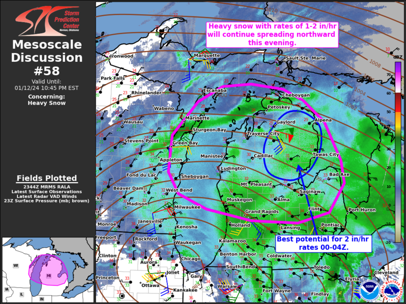
Areas affected...Portions of northern/central Lower Michigan and far
northeast Wisconsin
Concerning...Heavy snow
Valid 122347Z - 130345Z
SUMMARY...Heavy snow with rates of 1 to locally 2 in/hr will
continue spreading northward across Lower MI and northeast WI this
evening.
DISCUSSION...A fairly expansive swath of heavy snow with rates near
1 in/hr are ongoing across much of Lower MI this evening, largely
driven by a deep band of isentropic ascent ahead of a 984 mb surface
cyclone currently over northeast IL. Latest web cams across Lower MI
show snow sticking to roadways as surface temperatures continue to
nocturnally cool. Over the next few hours, the strong isentropic
ascent (50-60-kt 1-2 km cross-isotherm flow per regional VWP) will
continue northward in tandem with the northeastward-moving surface
cyclone. This will occur as ascent in the left exit region of a
robust southwesterly jet streak overspreads the area.
The strengthening deep-layer ascent coupled with increasingly cold
thermodynamic profiles with northward extent will continue to
support heavy snow with rates of 1-2 in/hr given a deep/saturated
dendritic growth zone. The best chance for localized 2 in/hr rates
could develop across northeastern Lower MI from 00-04Z, where colder
temperatures and stronger ascent should overlap for a couple hours
(supported by the latest high-resolution guidance). In addition, a
modest pressure gradient and related breezy surface winds should
continue to favor visibility reductions to 0.25 miles in the heavier
bursts of snow.
..Weinman.. 01/12/2024
...Please see www.spc.noaa.gov for graphic product...
ATTN...WFO...DTX...APX...GRR...MQT...GRB...MKX...
LAT...LON 42828544 43098686 43428775 43928809 44788799 45568719
45918639 45978545 45868442 45598376 45088307 44198258
43668248 43008299 42778397 42828544
|
|
Top/All Mesoscale Discussions/Forecast Products/Home
|
|


 @NWSSPC