|
| Mesoscale Discussion 60 |
|
< Previous MD Next MD >
|
|
Mesoscale Discussion 0060
NWS Storm Prediction Center Norman OK
0750 AM CST Sat Jan 13 2024
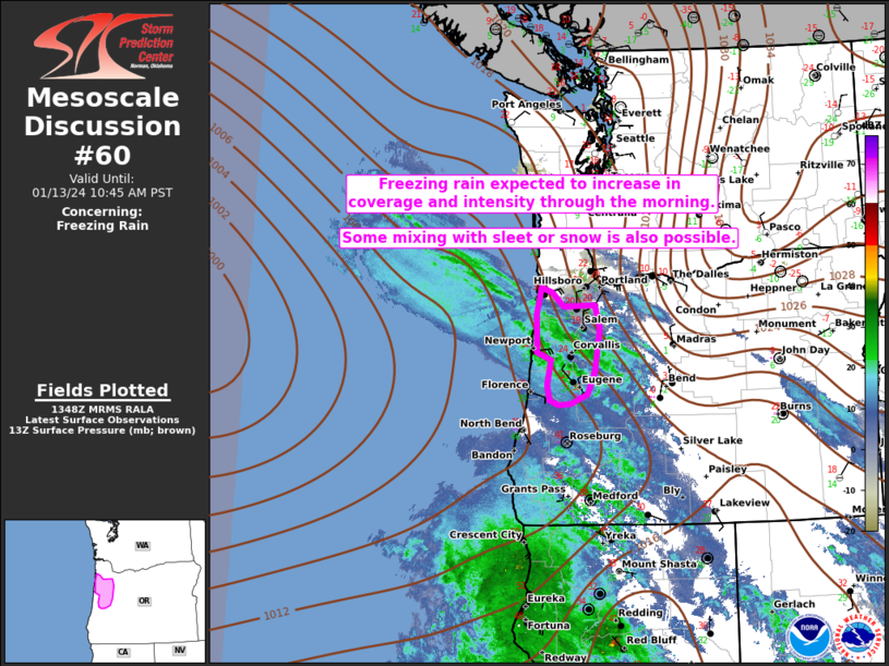
Areas affected...Northwest OR...including parts of the Willamette
Valley
Concerning...Freezing rain
Valid 131350Z - 131845Z
SUMMARY...Freezing rain is expected to increase in coverage and
intensity this morning. Some mixing with sleet is also possible.
DISCUSSION...An expansive anticyclone and related Arctic airmass is
centered over the northern Rockies this morning, and cold
temperatures have spread westward through the interior Northwest and
into the Columbia Gorge and Willamette Valley. Meanwhile, a
subtropical moisture plume has been drawn northward by a deep-layer
cyclone over the central Pacific (centered near 27N/149W), and then
eastward by a vigorous mid/upper-level shortwave trough and
deepening surface cyclone (centered near 44N/131W) approaching the
Pacific Northwest coast. This moisture, combined with ascent
attendant to the approaching shortwave, will support increasing
precipitation from southwest to northeast across much of OR today.
This will lead to increasing winter-precipitation rates in areas
where cold air is now entrenched.
In particular, expanding precipitation within the shallow cold
airmass and a strengthening warm nose in the 900-800 mb layer will
lead to an increasing freezing-rain threat this morning across parts
of the Willamette Valley. Freezing rain has already been reported in
Eugene, though areas farther north in the valley may initially mix
with sleet or snow, given the initially deeper subfreezing layer
noted in the 12Z SLE sounding. A transition to freezing rain is also
expected across parts of the coastal ranges, and in areas along the
immediate coast where adjacent terrain favors a greater intrusion of
shallow cold air.
Liquid-equivalent rates of 0.05-0.1 inch/hour will be possible
through the morning as precipitation gradually spreads northward.
Ice accretion will be rather efficient where temperatures can hold
in the mid/upper 20s F, as suggested by the observation of 0.05-inch
flat-ice accretion in the 13Z KEUG METAR when an initial band of
freezing rain moved through.
..Dean.. 01/13/2024
...Please see www.spc.noaa.gov for graphic product...
ATTN...WFO...MFR...PQR...
LAT...LON 44292275 43932291 43802326 43782350 43852370 44072374
44442367 44552395 45122397 45522386 45452364 45242341
45252276 44912266 44632271 44292275
|
|
Top/All Mesoscale Discussions/Forecast Products/Home
|
|


 @NWSSPC