|
| Mesoscale Discussion 1239 |
|
< Previous MD Next MD >
|
|
Mesoscale Discussion 1239
NWS Storm Prediction Center Norman OK
0132 PM CDT Sat Jul 10 2021
Areas affected...portions of central into eastern West Virginia
Concerning...Severe potential...Watch unlikely
Valid 101832Z - 102030Z
Probability of Watch Issuance...20 percent
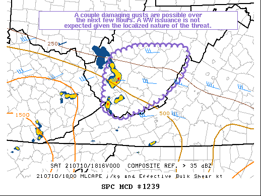
SUMMARY...At least a few damaging gusts remain possible over the
next few hours. However, the spatial coverage of severe winds is
expected to be relatively low overall and a Severe Thunderstorm
Watch issuance is not currently anticipated.
DISCUSSION...MRMS mosaic and KRLX radar data depict a small but
highly organized MCS propagating across central WV, with
semi-discrete storms exhibiting occasional transient supercell
structures to the south of the bowing complex (some with a history
of tree damage).
30-35 kts of effective bulk shear is evident across the Ohio
Valley/Mid-Atlantic regions based on 18Z mesoanalysis, with the
shear vectors orthogonal to the MCS. The bowing-structure MCS and
nearby transient supercells are expected to remain organized through
the mid afternoon hours. Nonetheless, buoyancy is marginal, with
generally less than 500 J/kg MLCAPE noted (fueled primarily by 7-8
C/km low-level lapse rates). The KRLX showed mainly 30-40 kts of
leading-line flow about 200-500 ft AGL, and significant
intensification is not expected. As such, gusty winds may accompany
the stronger storms/bowing segments, and while a few severe gusts
cannot be ruled out, the lack of more widespread damaging wind
potential suggests a Severe Thunderstorm Watch is not needed.
..Squitieri/Bunting.. 07/10/2021
...Please see www.spc.noaa.gov for graphic product...
ATTN...WFO...LWX...RNK...RLX...JKL...
LAT...LON 37428203 38218197 38628178 38818112 38808029 38787975
38727964 38527962 38087986 37628046 37368109 37198153
37198155 37428203
|
|
Top/All Mesoscale Discussions/Forecast Products/Home
|
|


 @NWSSPC