|
| Mesoscale Discussion 1240 |
|
< Previous MD Next MD >
|
|
Mesoscale Discussion 1240
NWS Storm Prediction Center Norman OK
0217 PM CDT Sat Jul 10 2021
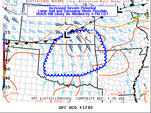
Areas affected...much of Oklahoma...southeast Kansas...and northwest
Arkansas
Concerning...Severe potential...Watch likely
Valid 101917Z - 102115Z
Probability of Watch Issuance...80 percent
SUMMARY...Thunderstorms will develop this afternoon and evening
across the region. Large hail and damaging winds will be the primary
threat, although a tornado or two cannot be ruled out. A watch will
likely be needed by 4 PM CDT.
DISCUSSION...A surface cold front across southwest Kansas is slowly
moving southeast this afternoon with an effective stationary front
extending from south-central into northeast Kansas. Along and south
of this frontal zone, diurnal heating has contributed to a very
unstable airmass as surface temperatures warm into the mid 80s F to
lower 90s F with surface dewpoints in the low-to-mid 70s F. As this
heating continues, surface-based inhibition will erode and several
clusters of thunderstorms will develop. Initial development --
likely before 21Z -- should occur across eastern Kansas within the
aforementioned frontal zone, with additional development later this
afternoon farther southwest across Oklahoma.
Surface-based CAPE in excess of 3000 J/kg, mid-level lapse rates
between 7 and 8 C/km, and effective-layer shear between 40-50 knots
will combine to support thunderstorms capable of large hail and
damaging thunderstorm wind gusts. Given the degree of instability
and effective-layer shear, a tornado or two will be possible with
thunderstorms, especially early in their life cycle when they remain
more discrete and may pose supercellular characteristics. With time,
congealing thunderstorm cold pools and outflows will promote upscale
growth into one or more south-southeast moving linear MCSs, with the
primary severe hazard transitioning to more of a widespread wind
damage potential.
A watch will likely be needed across portions of this area by
21Z/4PM CDT.
..Marsh/Bunting.. 07/10/2021
...Please see www.spc.noaa.gov for graphic product...
ATTN...WFO...LZK...SGF...TSA...ICT...OUN...DDC...
LAT...LON 35409937 37139858 37809734 38039598 37989467 37869429
36479369 35409376 34699587 34619926 35409937
|
|
Top/All Mesoscale Discussions/Forecast Products/Home
|
|


 @NWSSPC