|
| Mesoscale Discussion 1577 |
|
< Previous MD Next MD >
|
|
Mesoscale Discussion 1577
NWS Storm Prediction Center Norman OK
0825 PM CDT Mon Jul 22 2019
Areas affected...Southern Arizona
Concerning...Severe Thunderstorm Watch 539...
Valid 230125Z - 230300Z
The severe weather threat for Severe Thunderstorm Watch 539
continues.
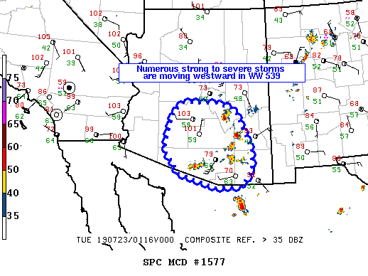
SUMMARY...Numerous strong to severe storms are moving westward in
severe thunderstorm watch 539.
DISCUSSION...Several storms and outflow boundaries have developed
and are moving north, south, and west toward eastern Pinal county.
The very steep low-level lapse rates (8+ C/km per PHX and TUS 00Z
RAOB) suggest these storms will pose a threat for severe downdraft
winds. Storm/outflow boundary mergers in this area may lead to
additional storm development and clustering which could lead to an
increased risk for severe wind gusts in this area in the next 1 to 2
hours. Any storm cluster/outflow that develops from this expected
storm interaction may pose a threat for severe wind gusts and
blowing dust possibly as far west as the Phoenix metro area.
..Bentley.. 07/23/2019
...Please see www.spc.noaa.gov for graphic product...
ATTN...WFO...TWC...FGZ...PSR...
LAT...LON 31711252 32481308 33651276 33961236 33941104 33711042
33261017 32380982 31730982 31451010 31271027 31271115
31711252
|
|
Top/All Mesoscale Discussions/Forecast Products/Home
|
|


 @NWSSPC