|
| Mesoscale Discussion 1576 |
|
< Previous MD Next MD >
|
|
Mesoscale Discussion 1576
NWS Storm Prediction Center Norman OK
0751 PM CDT Mon Jul 22 2019
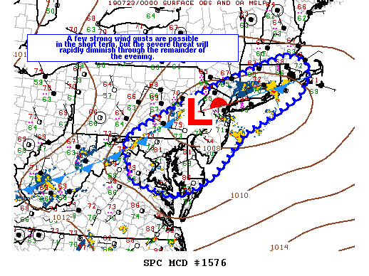
Areas affected...portions of northern VA...MD...DE...southeast
PA...NJ...southern NY...CT...RI...and eastern MA
Concerning...Severe Thunderstorm Watch 538...
Valid 230051Z - 230215Z
The severe weather threat for Severe Thunderstorm Watch 538
continues.
SUMMARY...A few strong wind gusts are possible in the short term
across parts of the Mid-Atlantic and southern New England. However,
overall severe threat is expected to rapidly decrease over the next
1-2 hours.
DISCUSSION...The overall severe threat has diminished across WW 538
this evening. A couple of areas may still see locally gusty wind
potential the next 1-2 hours, including the northern Chesapeake Bay
area as well as parts of RI and perhaps into southeast MA. Strong
storms are still tracking across these areas, but investigation of
5km CAPPI loop indicates weakening over the last 30 minutes or so.
With the loss of daytime heating, boundary-layer inhibition will
increase, along with damaging wind potential. While some strong
storms could develop along the eastward-advancing cool front into
tonight, damaging wind potential should be mitigated by increasing
inhibition, weakening shear and a downstream airmass that has been
largely overturned by earlier convection. As such, WW 538 is
expected to expire as scheduled at 02z this evening.
..Leitman.. 07/23/2019
...Please see www.spc.noaa.gov for graphic product...
ATTN...WFO...BOX...OKX...ALY...PHI...BGM...AKQ...CTP...LWX...
LAT...LON 38567470 38087569 37967641 38367788 39197822 39547825
39867794 40367694 41287486 41877304 42257151 42077070
41617064 41057101 40477207 39937336 38567470
|
|
Top/All Mesoscale Discussions/Forecast Products/Home
|
|


 @NWSSPC