|
| Mesoscale Discussion 1568 |
|
< Previous MD Next MD >
|
|
Mesoscale Discussion 1568
NWS Storm Prediction Center Norman OK
1211 PM CDT Mon Jul 22 2019
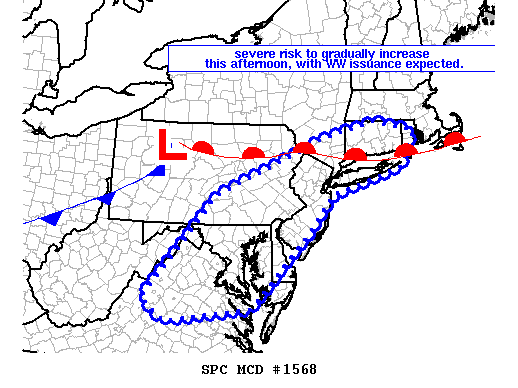
Areas affected...southern New England southwest to northern Virginia
Concerning...Severe potential...Watch likely
Valid 221711Z - 221845Z
Probability of Watch Issuance...80 percent
SUMMARY...Severe risk -- mainly in the form of locally damaging
winds -- will increase over the next new hours across southern New
England and the mid-Atlantic region. A severe thunderstorm watch
will likely be required.
DISCUSSION...Despite modest lapse rates aloft, daytime heating of a
moist warm-sector (east of the advancing cold front crossing western
PA and south of a warm front lying from northern PA to southern New
England) is allowing gradual airmass destabilization to occur.
Latest visible imagery continues to reveal cu/cb development, within
the zone of clearing (per visible imagery) east of the higher
terrain.
With continued heating/destabilization, and a gradual increase in
southwesterly mid-level flow across the region ahead of the
advancing upper trough, the environment will become increasingly
supportive of organized storms. Attendant risk for locally damaging
winds will accompany stronger multicell/transient supercell storms,
with this risk expected to become sufficient to warrant WW issuance
within the next hour.
..Goss/Guyer.. 07/22/2019
...Please see www.spc.noaa.gov for graphic product...
ATTN...WFO...BOX...OKX...ALY...PHI...BGM...AKQ...CTP...LWX...
RNK...
LAT...LON 42027265 41767146 40977189 40377395 39517467 37847631
37547877 38047943 40407734 41677415 42027265
|
|
Top/All Mesoscale Discussions/Forecast Products/Home
|
|


 @NWSSPC