|
| Mesoscale Discussion 1566 |
|
< Previous MD Next MD >
|
|
Mesoscale Discussion 1566
NWS Storm Prediction Center Norman OK
0959 PM CDT Sun Jul 21 2019
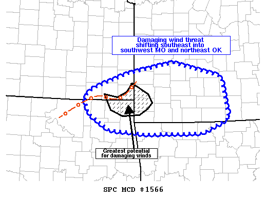
Areas affected...far southeast KS into southwest MO...northeast OK
and northwest AR
Concerning...Severe Thunderstorm Watch 537...
Valid 220259Z - 220400Z
The severe weather threat for Severe Thunderstorm Watch 537
continues.
SUMMARY...A corridor of damaging winds is possible across parts of
far southwest MO into far northeast OK over the next hour.
DISCUSSION...Intense wind gusts have occurred across southeast KS
this evening as the cluster of storms has organized into a bowing
segment across Cherokee and Labette counties. Storms will continue
shifting southeast at around 30-35 kt. A corridor of greater wind
speeds may continue downstream into Jasper and Newton Counties in
southwest MO and Ottawa and Craig counties in OK. This area remains
moderately unstable with only weak inhibition noted in 02z
mesoanalysis and condition will remain favorable for strong
downdrafts in the short-term. With time and southeastward extent,
expected this bowing segment to gradually weaken over the next
couple of hours.
..Leitman.. 07/22/2019
...Please see www.spc.noaa.gov for graphic product...
ATTN...WFO...LZK...SGF...TSA...ICT...
LAT...LON 37589478 37819351 37499222 36579204 36279276 36269428
36359529 36709587 37059598 37259574 37589478
|
|
Top/All Mesoscale Discussions/Forecast Products/Home
|
|


 @NWSSPC