|
| Mesoscale Discussion 1553 |
|
< Previous MD Next MD >
|
|
Mesoscale Discussion 1553
NWS Storm Prediction Center Norman OK
0807 PM CDT Sun Jul 07 2024
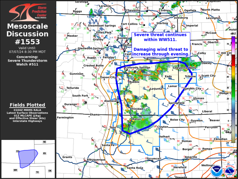
Areas affected...southeast Colorado...far western
Kansas...northeastern New Mexico
Concerning...Severe Thunderstorm Watch 511...
Valid 080107Z - 080230Z
The severe weather threat for Severe Thunderstorm Watch 511
continues.
SUMMARY...Severe threat continues within WW511. Damaging wind threat
will increase through the evening.
DISCUSSION...Several thunderstorms continue across southeastern
Colorado into northeastern New Mexico, with trends over the last
hour favoring clustering of supercells. Evolution through the
evening is still expected to favor attempts at upscale growth along
strengthening cold pools and eventual southeastward propagating MCS
moving out of southeastern Colorado. This regime would support an
increase in risk for damaging wind over the next couple of hours,
along with a continued threat for occasional large hail. Local
spatial expansion of WW511 may be needed to cover this threat across
southeastern Colorado and potentially into far western Kansas.
..Thornton/Hart.. 07/08/2024
...Please see www.spc.noaa.gov for graphic product...
ATTN...WFO...DDC...GLD...AMA...PUB...BOU...ABQ...
LAT...LON 37410495 37910513 38490527 38870522 38960482 39080404
39090344 39140266 39160208 39070169 38650136 38490136
37570216 37250247 36770314 36530358 36240450 36360488
37410495
|
|
Top/All Mesoscale Discussions/Forecast Products/Home
|
|


 @NWSSPC