 Note:
The expiration time in the watch graphic is amended if the watch is
replaced, cancelled or extended.
Note:
Note:
The expiration time in the watch graphic is amended if the watch is
replaced, cancelled or extended.
Note: Click for
Watch Status Reports.
SEL3
URGENT - IMMEDIATE BROADCAST REQUESTED
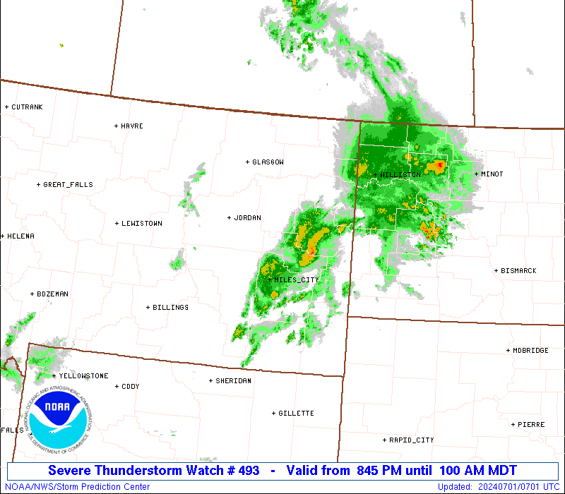
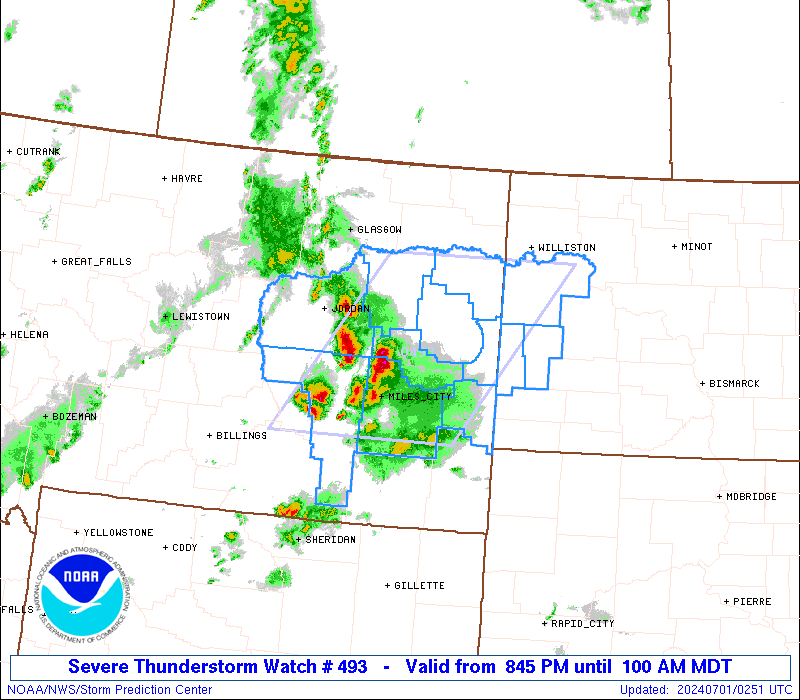
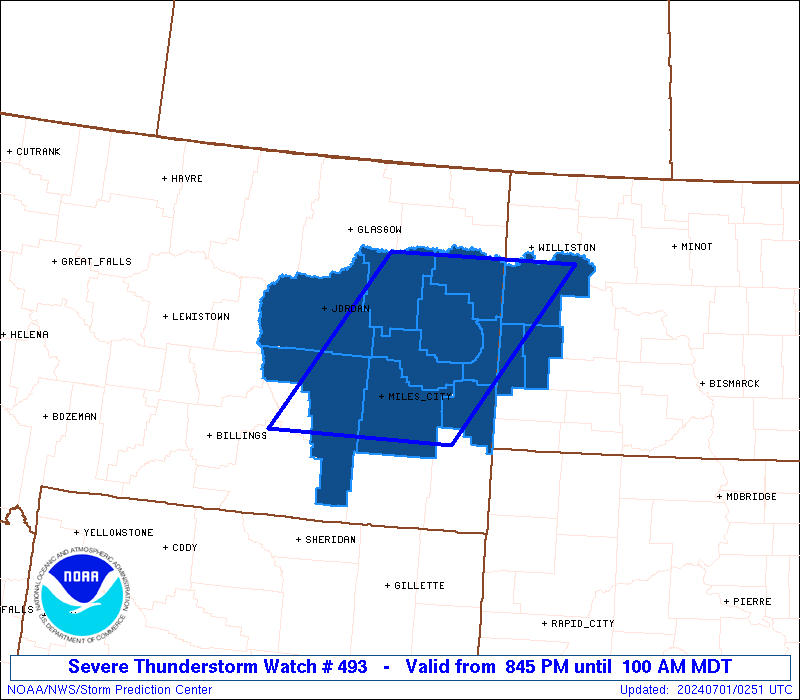
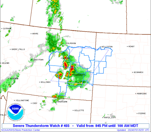
Severe Thunderstorm Watch Number 493
NWS Storm Prediction Center Norman OK
845 PM MDT Sun Jun 30 2024
The NWS Storm Prediction Center has issued a
* Severe Thunderstorm Watch for portions of
Eastern Montana
Western North Dakota
* Effective this Sunday night and Monday morning from 845 PM
until 100 AM MDT.
* Primary threats include...
Scattered damaging winds and isolated significant gusts to 75
mph possible
Scattered large hail and isolated very large hail events to 2
inches in diameter possible
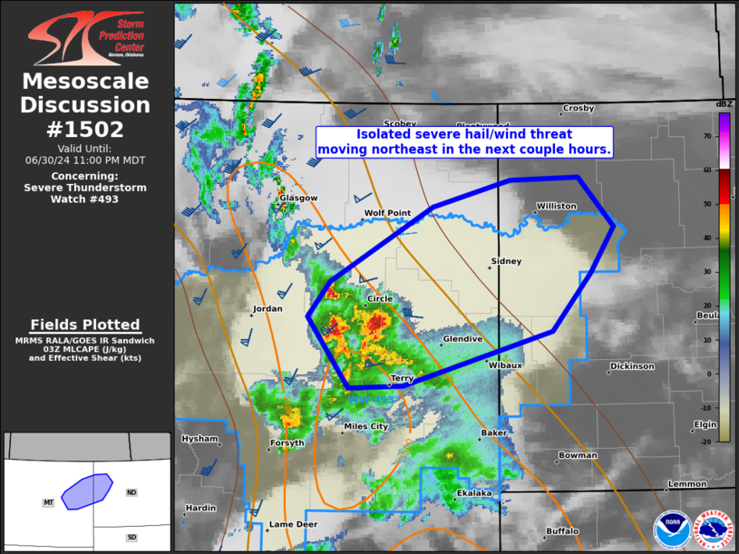
SUMMARY...Scattered thunderstorms will continue to intensify and
pose a risk for severe gusts (60-75 mph) and large hail (1 to 2
inches in diameter). This thunderstorm activity will probably grow
upscale into a linear cluster as it moves east-northeast across the
Watch area.
The severe thunderstorm watch area is approximately along and 70
statute miles east and west of a line from 25 miles north northwest
of Sidney MT to 35 miles south southwest of Miles City MT. For a
complete depiction of the watch see the associated watch outline
update (WOUS64 KWNS WOU3).
PRECAUTIONARY/PREPAREDNESS ACTIONS...
REMEMBER...A Severe Thunderstorm Watch means conditions are
favorable for severe thunderstorms in and close to the watch area.
Persons in these areas should be on the lookout for threatening
weather conditions and listen for later statements and possible
warnings. Severe thunderstorms can and occasionally do produce
tornadoes.
&&
AVIATION...A few severe thunderstorms with hail surface and aloft to
2 inches. Extreme turbulence and surface wind gusts to 65 knots. A
few cumulonimbi with maximum tops to 500. Mean storm motion vector
25040.
...Smith
 Note:
The Aviation Watch (SAW) product is an approximation to the watch area.
The actual watch is depicted by the shaded areas.
Note:
The Aviation Watch (SAW) product is an approximation to the watch area.
The actual watch is depicted by the shaded areas.
   SAW3
   WW 493 SEVERE TSTM MT ND 010245Z - 010700Z
   AXIS..70 STATUTE MILES EAST AND WEST OF LINE..
   25NNW SDY/SIDNEY MT/ - 35SSW MLS/MILES CITY MT/
   ..AVIATION COORDS.. 60NM E/W /32WSW ISN - 27SSW MLS/
   HAIL SURFACE AND ALOFT..2 INCHES. WIND GUSTS..65 KNOTS.
   MAX TOPS TO 500. MEAN STORM MOTION VECTOR 25040.

   LAT...LON 48020289 45950470 45950762 48020592

   THIS IS AN APPROXIMATION TO THE WATCH AREA.  FOR A
   COMPLETE DEPICTION OF THE WATCH SEE WOUS64 KWNS
   FOR WOU3.
Watch 493 Status Report Messages:
STATUS REPORT #2 ON WW 493

VALID 010650Z - 010700Z

SEVERE WEATHER THREAT CONTINUES RIGHT OF A LINE FROM 5 SW BHK TO
25 NE MLS TO 30 NNW SDY.

REMAINING VALID PORTION OF WW 493 MAY BE ALLOWED TO EXPIRE AT
01/07Z.
..KERR..07/01/24

ATTN...WFO...BYZ...GGW...BIS...

&&

STATUS REPORT FOR WS 493

SEVERE WEATHER THREAT CONTINUES FOR THE FOLLOWING AREAS

MTC021-025-079-083-087-109-010700-

MT
.    MONTANA COUNTIES INCLUDED ARE

DAWSON		     FALLON		 PRAIRIE
RICHLAND	     ROSEBUD		 WIBAUX
$$


NDC007-033-053-010700-

ND
.    NORTH DAKOTA COUNTIES INCLUDED ARE

BILLINGS	     GOLDEN VALLEY	 MCKENZIE
$$


THE WATCH STATUS MESSAGE IS FOR GUIDANCE PURPOSES ONLY.  PLEASE
REFER TO WATCH COUNTY NOTIFICATION STATEMENTS FOR OFFICIAL
INFORMATION ON COUNTIES...INDEPENDENT CITIES AND MARINE ZONES
CLEARED FROM SEVERE THUNDERSTORM AND TORNADO WATCHES.
$$

STATUS REPORT #1 ON WW 493

VALID 010435Z - 010540Z

SEVERE WEATHER THREAT CONTINUES RIGHT OF A LINE FROM 65 W MLS TO
35 WSW GDV TO 15 ESE OLF.

FOR ADDITIONAL INFORMATION SEE MESOSCALE DISCUSSION 1502.

..GRAMS..07/01/24

ATTN...WFO...BYZ...GGW...BIS...

&&

STATUS REPORT FOR WS 493

SEVERE WEATHER THREAT CONTINUES FOR THE FOLLOWING AREAS

MTC021-025-079-083-087-109-010540-

MT
.    MONTANA COUNTIES INCLUDED ARE

DAWSON		     FALLON		 PRAIRIE
RICHLAND	     ROSEBUD		 WIBAUX
$$


NDC007-033-053-010540-

ND
.    NORTH DAKOTA COUNTIES INCLUDED ARE

BILLINGS	     GOLDEN VALLEY	 MCKENZIE
$$


THE WATCH STATUS MESSAGE IS FOR GUIDANCE PURPOSES ONLY.  PLEASE
REFER TO WATCH COUNTY NOTIFICATION STATEMENTS FOR OFFICIAL
INFORMATION ON COUNTIES...INDEPENDENT CITIES AND MARINE ZONES
CLEARED FROM SEVERE THUNDERSTORM AND TORNADO WATCHES.
$$
Note:
Click for Complete Product Text.
Tornadoes
Probability of 2 or more tornadoes
|
Low (<5%)
|
Probability of 1 or more strong (EF2-EF5) tornadoes
|
Low (<2%)
|
Wind
Probability of 10 or more severe wind events
|
Mod (50%)
|
Probability of 1 or more wind events > 65 knots
|
Mod (30%)
|
Hail
Probability of 10 or more severe hail events
|
Mod (40%)
|
Probability of 1 or more hailstones > 2 inches
|
Mod (30%)
|
Combined Severe Hail/Wind
Probability of 6 or more combined severe hail/wind events
|
High (80%)
|
For each watch, probabilities for particular events inside the watch
(listed above in each table) are determined by the issuing forecaster.
The "Low" category contains probability values ranging from less than 2%
to 20% (EF2-EF5 tornadoes), less than 5% to 20% (all other probabilities),
"Moderate" from 30% to 60%, and "High" from 70% to greater than 95%.
High values are bolded and lighter in color to provide awareness of
an increased threat for a particular event.


 @NWSSPC