Note:
The expiration time in the watch graphic is amended if the watch is
replaced, cancelled or extended.
Note:
Note:
The expiration time in the watch graphic is amended if the watch is
replaced, cancelled or extended.
Note: Click for
Watch Status Reports.
SEL5
URGENT - IMMEDIATE BROADCAST REQUESTED
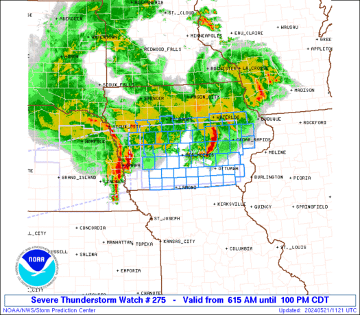
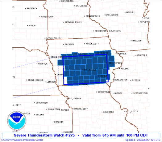
Severe Thunderstorm Watch Number 275
NWS Storm Prediction Center Norman OK
615 AM CDT Tue May 21 2024
The NWS Storm Prediction Center has issued a
* Severe Thunderstorm Watch for portions of
Central and southern Iowa
* Effective this Tuesday morning and afternoon from 615 AM until
100 PM CDT.
* Primary threats include...
Scattered damaging winds and isolated significant gusts to 75
mph possible
Isolated large hail events to 1.5 inches in diameter possible
A tornado or two possible
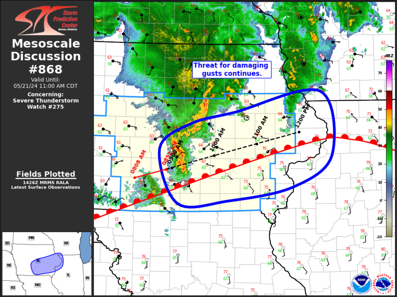
SUMMARY...Clusters of thunderstorms -- including an organized bowing
complex initially over eastern NE -- will pose a threat mainly for
severe gusts while crossing the watch area from west to east. A
tornado or two cannot be ruled out, especially near an outflow
boundary draped across central/south-central IA. Isolated large
hail is possible. This is a precursor to the main severe-weather
threat expected later today, for which we have a "Moderate Risk"
outlook.
The severe thunderstorm watch area is approximately along and 60
statute miles north and south of a line from 80 miles west of Des
Moines IA to 25 miles south southeast of Cedar Rapids IA. For a
complete depiction of the watch see the associated watch outline
update (WOUS64 KWNS WOU5).
PRECAUTIONARY/PREPAREDNESS ACTIONS...
REMEMBER...A Severe Thunderstorm Watch means conditions are
favorable for severe thunderstorms in and close to the watch area.
Persons in these areas should be on the lookout for threatening
weather conditions and listen for later statements and possible
warnings. Severe thunderstorms can and occasionally do produce
tornadoes.
&&
OTHER WATCH INFORMATION...CONTINUE...WW 274...
AVIATION...A few severe thunderstorms with hail surface and aloft to
1.5 inches. Extreme turbulence and surface wind gusts to 65 knots. A
few cumulonimbi with maximum tops to 550. Mean storm motion vector
26045.
...Edwards
   SEL5

   URGENT - IMMEDIATE BROADCAST REQUESTED
   Severe Thunderstorm Watch Number 275
   NWS Storm Prediction Center Norman OK
   615 AM CDT Tue May 21 2024

   The NWS Storm Prediction Center has issued a

   * Severe Thunderstorm Watch for portions of
     Central and southern Iowa

   * Effective this Tuesday morning and afternoon from 615 AM until
     100 PM CDT.

   * Primary threats include...
     Scattered damaging winds and isolated significant gusts to 75
       mph possible
     Isolated large hail events to 1.5 inches in diameter possible
     A tornado or two possible

   SUMMARY...Clusters of thunderstorms -- including an organized bowing
   complex initially over eastern NE -- will pose a threat mainly for
   severe gusts while crossing the watch area from west to east.  A
   tornado or two cannot be ruled out, especially near an outflow
   boundary draped across central/south-central IA.  Isolated large
   hail is possible.  This is a precursor to the main severe-weather
   threat expected later today, for which we have a "Moderate Risk"
   outlook.

   The severe thunderstorm watch area is approximately along and 60
   statute miles north and south of a line from 80 miles west of Des
   Moines IA to 25 miles south southeast of Cedar Rapids IA. For a
   complete depiction of the watch see the associated watch outline
   update (WOUS64 KWNS WOU5).

   PRECAUTIONARY/PREPAREDNESS ACTIONS...

   REMEMBER...A Severe Thunderstorm Watch means conditions are
   favorable for severe thunderstorms in and close to the watch area.
   Persons in these areas should be on the lookout for threatening
   weather conditions and listen for later statements and possible
   warnings. Severe thunderstorms can and occasionally do produce
   tornadoes.

   &&

   OTHER WATCH INFORMATION...CONTINUE...WW 274...

   AVIATION...A few severe thunderstorms with hail surface and aloft to
   1.5 inches. Extreme turbulence and surface wind gusts to 65 knots. A
   few cumulonimbi with maximum tops to 550. Mean storm motion vector
   26045.

   ...Edwards
 Note:
The Aviation Watch (SAW) product is an approximation to the watch area.
The actual watch is depicted by the shaded areas.
Note:
The Aviation Watch (SAW) product is an approximation to the watch area.
The actual watch is depicted by the shaded areas.
   SAW5
   WW 275 SEVERE TSTM IA 211115Z - 211800Z
   AXIS..60 STATUTE MILES NORTH AND SOUTH OF LINE..
   80W DSM/DES MOINES IA/ - 25SSE CID/CEDAR RAPIDS IA/
   ..AVIATION COORDS.. 50NM N/S /32NE OVR - 4ENE IOW/
   HAIL SURFACE AND ALOFT..1.5 INCHES. WIND GUSTS..65 KNOTS.
   MAX TOPS TO 550. MEAN STORM MOTION VECTOR 26045.

   LAT...LON 42399522 42419154 40689154 40659522

   THIS IS AN APPROXIMATION TO THE WATCH AREA.  FOR A
   COMPLETE DEPICTION OF THE WATCH SEE WOUS64 KWNS
   FOR WOU5.
Watch 275 Status Report Messages:
STATUS REPORT #1 ON WW 275

VALID 211545Z - 211640Z

SEVERE WEATHER THREAT CONTINUES RIGHT OF A LINE FROM 25 NNE SDA
TO 10 SW DSM TO 25 NNE OXV TO 10 NW ALO.

FOR ADDITIONAL INFORMATION SEE MESOSCALE DISCUSSION 868

..MOSIER..05/21/24

ATTN...WFO...DMX...DVN...

&&

STATUS REPORT FOR WS 275

SEVERE WEATHER THREAT CONTINUES FOR THE FOLLOWING AREAS

IAC003-007-011-013-019-031-039-051-053-055-087-095-101-103-105-
107-113-117-121-123-125-135-157-159-171-173-175-177-179-181-183-
185-211640-

IA
.    IOWA COUNTIES INCLUDED ARE

ADAMS		     APPANOOSE		 BENTON
BLACK HAWK	     BUCHANAN		 CEDAR
CLARKE		     DAVIS		 DECATUR
DELAWARE	     HENRY		 IOWA
JEFFERSON	     JOHNSON		 JONES
KEOKUK		     LINN		 LUCAS
MADISON 	     MAHASKA		 MARION
MONROE		     POWESHIEK		 RINGGOLD
TAMA		     TAYLOR		 UNION
VAN BUREN	     WAPELLO		 WARREN
WASHINGTON	     WAYNE
$$


THE WATCH STATUS MESSAGE IS FOR GUIDANCE PURPOSES ONLY.  PLEASE
REFER TO WATCH COUNTY NOTIFICATION STATEMENTS FOR OFFICIAL
INFORMATION ON COUNTIES...INDEPENDENT CITIES AND MARINE ZONES
CLEARED FROM SEVERE THUNDERSTORM AND TORNADO WATCHES.
$$
Note:
Click for Complete Product Text.
Tornadoes
Probability of 2 or more tornadoes
|
Low (20%)
|
Probability of 1 or more strong (EF2-EF5) tornadoes
|
Low (10%)
|
Wind
Probability of 10 or more severe wind events
|
Mod (50%)
|
Probability of 1 or more wind events > 65 knots
|
Mod (50%)
|
Hail
Probability of 10 or more severe hail events
|
Mod (30%)
|
Probability of 1 or more hailstones > 2 inches
|
Low (10%)
|
Combined Severe Hail/Wind
Probability of 6 or more combined severe hail/wind events
|
High (70%)
|
For each watch, probabilities for particular events inside the watch
(listed above in each table) are determined by the issuing forecaster.
The "Low" category contains probability values ranging from less than 2%
to 20% (EF2-EF5 tornadoes), less than 5% to 20% (all other probabilities),
"Moderate" from 30% to 60%, and "High" from 70% to greater than 95%.
High values are bolded and lighter in color to provide awareness of
an increased threat for a particular event.


 @NWSSPC