 Note:
The expiration time in the watch graphic is amended if the watch is
replaced, cancelled or extended.
Note:
Note:
The expiration time in the watch graphic is amended if the watch is
replaced, cancelled or extended.
Note: Click for
Watch Status Reports.
SEL6
URGENT - IMMEDIATE BROADCAST REQUESTED
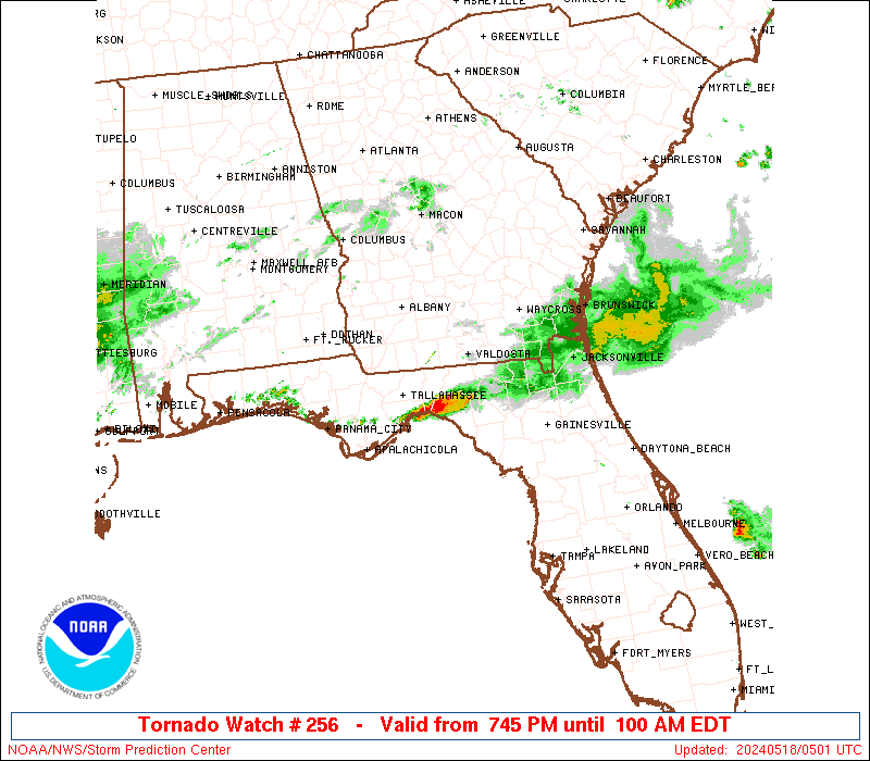
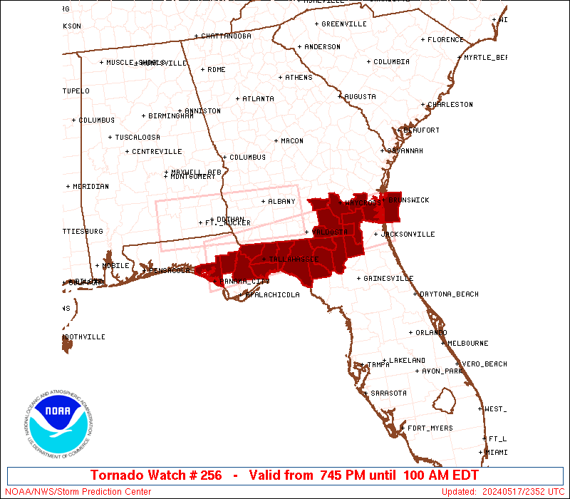
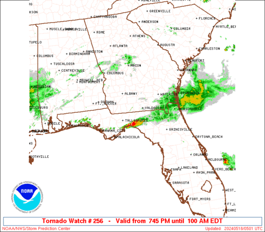
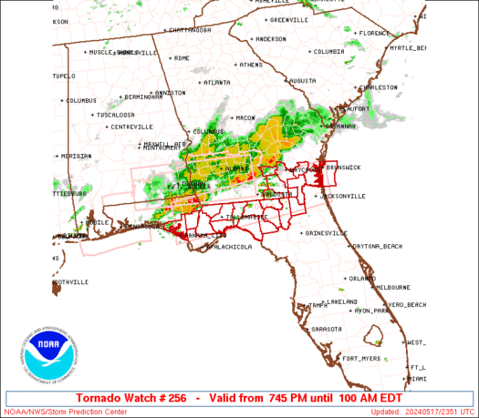
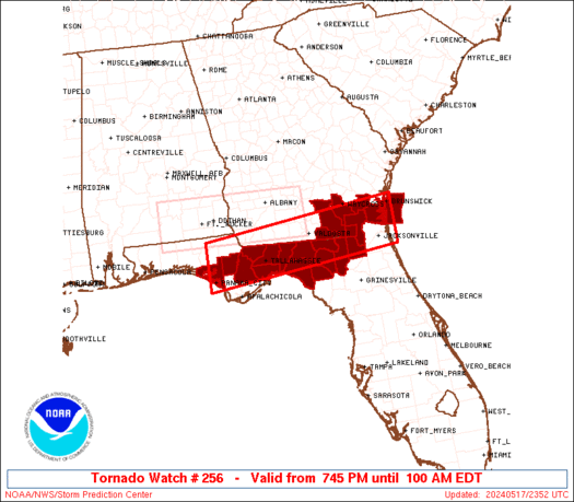
Tornado Watch Number 256
NWS Storm Prediction Center Norman OK
745 PM EDT Fri May 17 2024
The NWS Storm Prediction Center has issued a
* Tornado Watch for portions of
North Florida and Panhandle
Southeast Georgia
Coastal Waters
* Effective this Friday night and Saturday morning from 745 PM
until 100 AM EDT.
* Primary threats include...
A couple tornadoes possible
Scattered damaging wind gusts to 70 mph possible
Isolated large hail events to 1.5 inches in diameter possible
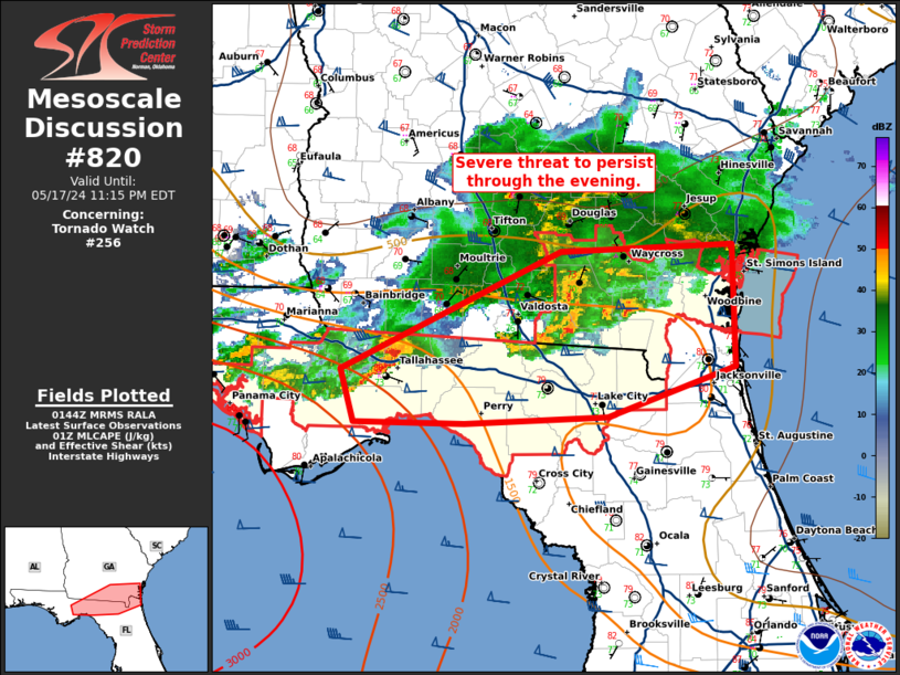
SUMMARY...A broken band of severe thunderstorms will move
east-southeast into the Florida Panhandle and adjacent portions of
southeast Georgia and north Florida during this evening. In
addition to the risk for a couple of tornadoes, severe gusts 60-70
mph resulting in wind damage will be possible with any embedded
supercells or bowing segments, as they move east-southeast across
the Watch area.
The tornado watch area is approximately along and 35 statute miles
north and south of a line from 25 miles south southeast of Brunswick
GA to 45 miles southwest of Marianna FL. For a complete depiction of
the watch see the associated watch outline update (WOUS64 KWNS
WOU6).
PRECAUTIONARY/PREPAREDNESS ACTIONS...
REMEMBER...A Tornado Watch means conditions are favorable for
tornadoes and severe thunderstorms in and close to the watch
area. Persons in these areas should be on the lookout for
threatening weather conditions and listen for later statements
and possible warnings.
&&
OTHER WATCH INFORMATION...CONTINUE...WW 253...WW 254...WW 255...
AVIATION...Tornadoes and a few severe thunderstorms with hail
surface and aloft to 1.5 inches. Extreme turbulence and surface wind
gusts to 60 knots. A few cumulonimbi with maximum tops to 450. Mean
storm motion vector 30030.
...Smith
   SEL6

   URGENT - IMMEDIATE BROADCAST REQUESTED
   Tornado Watch Number 256
   NWS Storm Prediction Center Norman OK
   745 PM EDT Fri May 17 2024

   The NWS Storm Prediction Center has issued a

   * Tornado Watch for portions of
     North Florida and Panhandle
     Southeast Georgia
     Coastal Waters

   * Effective this Friday night and Saturday morning from 745 PM
     until 100 AM EDT.

   * Primary threats include...
     A couple tornadoes possible
     Scattered damaging wind gusts to 70 mph possible
     Isolated large hail events to 1.5 inches in diameter possible

   SUMMARY...A broken band of severe thunderstorms will move
   east-southeast into the Florida Panhandle and adjacent portions of
   southeast Georgia and north Florida during this evening.  In
   addition to the risk for a couple of tornadoes, severe gusts 60-70
   mph resulting in wind damage will be possible with any embedded
   supercells or bowing segments, as they move east-southeast across
   the Watch area.

   The tornado watch area is approximately along and 35 statute miles
   north and south of a line from 25 miles south southeast of Brunswick
   GA to 45 miles southwest of Marianna FL. For a complete depiction of
   the watch see the associated watch outline update (WOUS64 KWNS
   WOU6).

   PRECAUTIONARY/PREPAREDNESS ACTIONS...

   REMEMBER...A Tornado Watch means conditions are favorable for
   tornadoes and severe thunderstorms in and close to the watch
   area. Persons in these areas should be on the lookout for
   threatening weather conditions and listen for later statements
   and possible warnings.

   &&

   OTHER WATCH INFORMATION...CONTINUE...WW 253...WW 254...WW 255...

   AVIATION...Tornadoes and a few severe thunderstorms with hail
   surface and aloft to 1.5 inches. Extreme turbulence and surface wind
   gusts to 60 knots. A few cumulonimbi with maximum tops to 450. Mean
   storm motion vector 30030.

   ...Smith
 Note:
The Aviation Watch (SAW) product is an approximation to the watch area.
The actual watch is depicted by the shaded areas.
Note:
The Aviation Watch (SAW) product is an approximation to the watch area.
The actual watch is depicted by the shaded areas.
   SAW6
   WW 256 TORNADO FL GA CW 172345Z - 180500Z
   AXIS..35 STATUTE MILES NORTH AND SOUTH OF LINE..
   25SSE SSI/BRUNSWICK GA/ - 45SW MAI/MARIANNA FL/
   ..AVIATION COORDS.. 30NM N/S /31NNE CRG - 57ESE CEW/
   HAIL SURFACE AND ALOFT..1.5 INCHES. WIND GUSTS..60 KNOTS.
   MAX TOPS TO 450. MEAN STORM MOTION VECTOR 30030.

   LAT...LON 30318129 29888571 30898571 31328129

   THIS IS AN APPROXIMATION TO THE WATCH AREA.  FOR A
   COMPLETE DEPICTION OF THE WATCH SEE WOUS64 KWNS
   FOR WOU6.
Watch 256 Status Report Messages:
STATUS REPORT #4 ON WW 256

VALID 180445Z - 180500Z

SEVERE WEATHER THREAT CONTINUES RIGHT OF A LINE FROM 30 NE AAF TO
25 E TLH TO 25 S VLD TO 30 N CTY.

REMAINING VALID PORTION OF WW 256 MAY BE ALLOWED TO EXPIRE AT
18/05Z.
..KERR..05/18/24

ATTN...WFO...JAX...TAE...

&&

STATUS REPORT FOR WT 256

SEVERE WEATHER THREAT CONTINUES FOR THE FOLLOWING AREAS

FLC065-067-079-123-129-180500-

FL
.    FLORIDA COUNTIES INCLUDED ARE

JEFFERSON	     LAFAYETTE		 MADISON
TAYLOR		     WAKULLA
$$


THE WATCH STATUS MESSAGE IS FOR GUIDANCE PURPOSES ONLY.  PLEASE
REFER TO WATCH COUNTY NOTIFICATION STATEMENTS FOR OFFICIAL
INFORMATION ON COUNTIES...INDEPENDENT CITIES AND MARINE ZONES
CLEARED FROM SEVERE THUNDERSTORM AND TORNADO WATCHES.
$$

STATUS REPORT #3 ON WW 256

VALID 180330Z - 180440Z

SEVERE WEATHER THREAT CONTINUES RIGHT OF A LINE FROM 15 NNE AAF
TO 10 NE TLH TO 10 WSW VLD TO 30 W SSI TO 35 ENE SSI.

..KERR..05/18/24

ATTN...WFO...JAX...TAE...

&&

STATUS REPORT FOR WT 256

SEVERE WEATHER THREAT CONTINUES FOR THE FOLLOWING AREAS

FLC003-023-047-065-067-073-079-121-123-129-180440-

FL
.    FLORIDA COUNTIES INCLUDED ARE

BAKER		     COLUMBIA		 HAMILTON
JEFFERSON	     LAFAYETTE		 LEON
MADISON 	     SUWANNEE		 TAYLOR
WAKULLA
$$


GAC039-049-101-180440-

GA
.    GEORGIA COUNTIES INCLUDED ARE

CAMDEN		     CHARLTON		 ECHOLS
$$


AMZ450-180440-

CW

.    ADJACENT COASTAL WATERS INCLUDED ARE

COASTAL WATERS FROM ALTAMAHA SOUND TO FERNANDINA BEACH FL OUT 20
NM

$$
THE WATCH STATUS MESSAGE IS FOR GUIDANCE PURPOSES ONLY.  PLEASE
REFER TO WATCH COUNTY NOTIFICATION STATEMENTS FOR OFFICIAL
INFORMATION ON COUNTIES...INDEPENDENT CITIES AND MARINE ZONES
CLEARED FROM SEVERE THUNDERSTORM AND TORNADO WATCHES.
$$

STATUS REPORT #2 ON WW 256

VALID 180250Z - 180340Z

SEVERE WEATHER THREAT CONTINUES RIGHT OF A LINE FROM 10 N AAF TO
5 NE TLH TO 15 WSW VLD TO 25 ESE AYS TO 35 ENE SSI.

..BENTLEY..05/18/24

ATTN...WFO...JAX...TAE...

&&

STATUS REPORT FOR WT 256

SEVERE WEATHER THREAT CONTINUES FOR THE FOLLOWING AREAS

FLC003-023-047-065-067-073-079-121-123-129-180340-

FL
.    FLORIDA COUNTIES INCLUDED ARE

BAKER		     COLUMBIA		 HAMILTON
JEFFERSON	     LAFAYETTE		 LEON
MADISON 	     SUWANNEE		 TAYLOR
WAKULLA
$$


GAC039-049-101-180340-

GA
.    GEORGIA COUNTIES INCLUDED ARE

CAMDEN		     CHARLTON		 ECHOLS
$$


AMZ450-180340-

CW

.    ADJACENT COASTAL WATERS INCLUDED ARE

COASTAL WATERS FROM ALTAMAHA SOUND TO FERNANDINA BEACH FL OUT 20
NM

$$
THE WATCH STATUS MESSAGE IS FOR GUIDANCE PURPOSES ONLY.  PLEASE
REFER TO WATCH COUNTY NOTIFICATION STATEMENTS FOR OFFICIAL
INFORMATION ON COUNTIES...INDEPENDENT CITIES AND MARINE ZONES
CLEARED FROM SEVERE THUNDERSTORM AND TORNADO WATCHES.
$$

STATUS REPORT #1 ON WW 256

VALID 180015Z - 180140Z

THE SEVERE WEATHER THREAT CONTINUES ACROSS THE ENTIRE WATCH AREA.

..DEAN..05/18/24

ATTN...WFO...JAX...TAE...

&&

STATUS REPORT FOR WT 256

SEVERE WEATHER THREAT CONTINUES FOR THE FOLLOWING AREAS

FLC003-005-013-023-039-047-065-067-073-077-079-121-123-129-
180140-

FL
.    FLORIDA COUNTIES INCLUDED ARE

BAKER		     BAY		 CALHOUN
COLUMBIA	     GADSDEN		 HAMILTON
JEFFERSON	     LAFAYETTE		 LEON
LIBERTY 	     MADISON		 SUWANNEE
TAYLOR		     WAKULLA
$$


GAC003-025-039-049-065-101-299-180140-

GA
.    GEORGIA COUNTIES INCLUDED ARE

ATKINSON	     BRANTLEY		 CAMDEN
CHARLTON	     CLINCH		 ECHOLS
WARE
$$


AMZ450-180140-

CW

.    ADJACENT COASTAL WATERS INCLUDED ARE

COASTAL WATERS FROM ALTAMAHA SOUND TO FERNANDINA BEACH FL OUT 20
NM

$$
THE WATCH STATUS MESSAGE IS FOR GUIDANCE PURPOSES ONLY.  PLEASE
REFER TO WATCH COUNTY NOTIFICATION STATEMENTS FOR OFFICIAL
INFORMATION ON COUNTIES...INDEPENDENT CITIES AND MARINE ZONES
CLEARED FROM SEVERE THUNDERSTORM AND TORNADO WATCHES.
$$
Note:
Click for Complete Product Text.
Tornadoes
Probability of 2 or more tornadoes
|
Mod (40%)
|
Probability of 1 or more strong (EF2-EF5) tornadoes
|
Low (20%)
|
Wind
Probability of 10 or more severe wind events
|
Mod (40%)
|
Probability of 1 or more wind events > 65 knots
|
Low (20%)
|
Hail
Probability of 10 or more severe hail events
|
Low (20%)
|
Probability of 1 or more hailstones > 2 inches
|
Low (10%)
|
Combined Severe Hail/Wind
Probability of 6 or more combined severe hail/wind events
|
High (70%)
|
For each watch, probabilities for particular events inside the watch
(listed above in each table) are determined by the issuing forecaster.
The "Low" category contains probability values ranging from less than 2%
to 20% (EF2-EF5 tornadoes), less than 5% to 20% (all other probabilities),
"Moderate" from 30% to 60%, and "High" from 70% to greater than 95%.
High values are bolded and lighter in color to provide awareness of
an increased threat for a particular event.


 @NWSSPC