 Note:
The expiration time in the watch graphic is amended if the watch is
replaced, cancelled or extended.
Note:
Note:
The expiration time in the watch graphic is amended if the watch is
replaced, cancelled or extended.
Note: Click for
Watch Status Reports.
SEL4
URGENT - IMMEDIATE BROADCAST REQUESTED
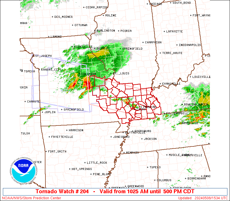
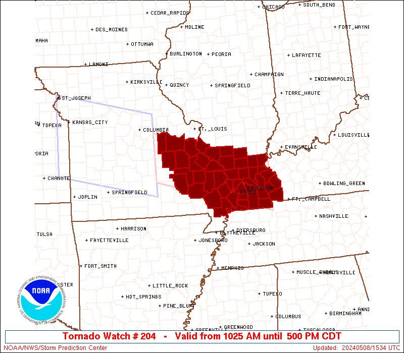
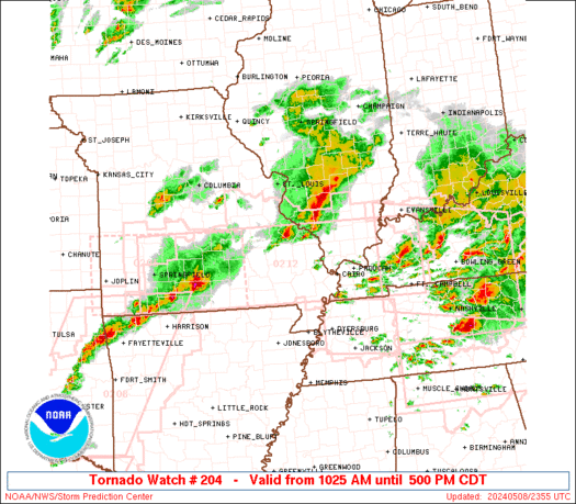
Tornado Watch Number 204
NWS Storm Prediction Center Norman OK
1025 AM CDT Wed May 8 2024
The NWS Storm Prediction Center has issued a
* Tornado Watch for portions of
Southern Illinois
Western Kentucky
Southeastern Missouri
* Effective this Wednesday morning and afternoon from 1025 AM
until 500 PM CDT.
* Primary threats include...
A few tornadoes likely with a couple intense tornadoes possible
Widespread large hail and scattered very large hail events to 3
inches in diameter likely
Widespread damaging winds and isolated significant gusts to 80
mph likely
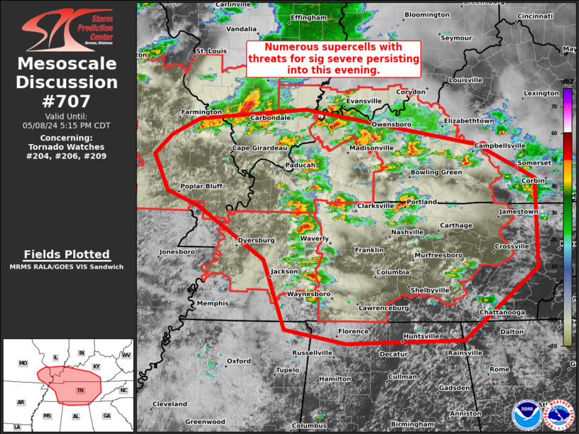
SUMMARY...A supercell cluster in Missouri will likely persist
through the afternoon while spreading east-southeastward toward
southern Illinois, southeastern Missouri and western Kentucky, with
some potential for additional storm development this afternoon. The
environment will become more favorable for surface-based storms
capable of producing tornadoes (a couple of which could be
strong/EF2+), severe wind swaths up to 80 mph, and very large hail
of 2-3 inches in diameter.
The tornado watch area is approximately along and 45 statute miles
north and south of a line from 5 miles south of Vichy MO to 40 miles
east of Paducah KY. For a complete depiction of the watch see the
associated watch outline update (WOUS64 KWNS WOU4).
PRECAUTIONARY/PREPAREDNESS ACTIONS...
REMEMBER...A Tornado Watch means conditions are favorable for
tornadoes and severe thunderstorms in and close to the watch
area. Persons in these areas should be on the lookout for
threatening weather conditions and listen for later statements
and possible warnings.
&&
OTHER WATCH INFORMATION...CONTINUE...WW 202...WW 203...
AVIATION...Tornadoes and a few severe thunderstorms with hail
surface and aloft to 3 inches. Extreme turbulence and surface wind
gusts to 70 knots. A few cumulonimbi with maximum tops to 550. Mean
storm motion vector 29030.
...Thompson

   SEL4

   URGENT - IMMEDIATE BROADCAST REQUESTED
   Tornado Watch Number 204
   NWS Storm Prediction Center Norman OK
   1025 AM CDT Wed May 8 2024

   The NWS Storm Prediction Center has issued a

   * Tornado Watch for portions of
     Southern Illinois
     Western Kentucky
     Southeastern Missouri

   * Effective this Wednesday morning and afternoon from 1025 AM
     until 500 PM CDT.

   * Primary threats include...
     A few tornadoes likely with a couple intense tornadoes possible
     Widespread large hail and scattered very large hail events to 3
       inches in diameter likely
     Widespread damaging winds and isolated significant gusts to 80
       mph likely

   SUMMARY...A supercell cluster in Missouri will likely persist
   through the afternoon while spreading east-southeastward toward
   southern Illinois, southeastern Missouri and western Kentucky, with
   some potential for additional storm development this afternoon.  The
   environment will become more favorable for surface-based storms
   capable of producing tornadoes (a couple of which could be
   strong/EF2+), severe wind swaths up to 80 mph, and very large hail
   of 2-3 inches in diameter.

   The tornado watch area is approximately along and 45 statute miles
   north and south of a line from 5 miles south of Vichy MO to 40 miles
   east of Paducah KY. For a complete depiction of the watch see the
   associated watch outline update (WOUS64 KWNS WOU4).

   PRECAUTIONARY/PREPAREDNESS ACTIONS...

   REMEMBER...A Tornado Watch means conditions are favorable for
   tornadoes and severe thunderstorms in and close to the watch
   area. Persons in these areas should be on the lookout for
   threatening weather conditions and listen for later statements
   and possible warnings.

   &&

   OTHER WATCH INFORMATION...CONTINUE...WW 202...WW 203...

   AVIATION...Tornadoes and a few severe thunderstorms with hail
   surface and aloft to 3 inches. Extreme turbulence and surface wind
   gusts to 70 knots. A few cumulonimbi with maximum tops to 550. Mean
   storm motion vector 29030.

   ...Thompson
 Note:
The Aviation Watch (SAW) product is an approximation to the watch area.
The actual watch is depicted by the shaded areas.
Note:
The Aviation Watch (SAW) product is an approximation to the watch area.
The actual watch is depicted by the shaded areas.
   SAW4
   WW 204 TORNADO IL KY MO 081525Z - 082200Z
   AXIS..45 STATUTE MILES NORTH AND SOUTH OF LINE..
   5S VIH/VICHY MO/ - 40E PAH/PADUCAH KY/
   ..AVIATION COORDS.. 40NM N/S /50SSE COU - 54SSW PXV/
   HAIL SURFACE AND ALOFT..3 INCHES. WIND GUSTS..70 KNOTS.
   MAX TOPS TO 550. MEAN STORM MOTION VECTOR 29030.

   LAT...LON 38719177 37728804 36418804 37419177

   THIS IS AN APPROXIMATION TO THE WATCH AREA.  FOR A
   COMPLETE DEPICTION OF THE WATCH SEE WOUS64 KWNS
   FOR WOU4.
Watch 204 Status Report Messages:
STATUS REPORT #6 ON WW 204

VALID 082145Z - 082240Z

THE SEVERE WEATHER THREAT CONTINUES ACROSS THE ENTIRE WATCH AREA.

..BENTLEY..05/08/24

ATTN...WFO...PAH...LSX...

&&

STATUS REPORT FOR WT 204

SEVERE WEATHER THREAT CONTINUES FOR THE FOLLOWING AREAS

ILC003-055-059-069-077-087-127-133-145-151-153-157-165-181-199-
082240-

IL
.    ILLINOIS COUNTIES INCLUDED ARE

ALEXANDER	     FRANKLIN		 GALLATIN
HARDIN		     JACKSON		 JOHNSON
MASSAC		     MONROE		 PERRY
POPE		     PULASKI		 RANDOLPH
SALINE		     UNION		 WILLIAMSON
$$


KYC007-033-035-039-055-075-083-105-139-143-145-157-221-082240-

KY
.    KENTUCKY COUNTIES INCLUDED ARE

BALLARD 	     CALDWELL		 CALLOWAY
CARLISLE	     CRITTENDEN 	 FULTON
GRAVES		     HICKMAN		 LIVINGSTON
LYON		     MCCRACKEN		 MARSHALL
TRIGG
$$


MOC017-031-055-071-073-093-099-123-133-143-157-179-186-187-201-
207-221-223-082240-

MO
.    MISSOURI COUNTIES INCLUDED ARE

BOLLINGER	     CAPE GIRARDEAU	 CRAWFORD
FRANKLIN	     GASCONADE		 IRON
JEFFERSON	     MADISON		 MISSISSIPPI
NEW MADRID	     PERRY		 REYNOLDS
STE. GENEVIEVE	     ST. FRANCOIS	 SCOTT
STODDARD	     WASHINGTON 	 WAYNE
$$


THE WATCH STATUS MESSAGE IS FOR GUIDANCE PURPOSES ONLY.  PLEASE
REFER TO WATCH COUNTY NOTIFICATION STATEMENTS FOR OFFICIAL
INFORMATION ON COUNTIES...INDEPENDENT CITIES AND MARINE ZONES
CLEARED FROM SEVERE THUNDERSTORM AND TORNADO WATCHES.
$$

STATUS REPORT #5 ON WW 204

VALID 082025Z - 082140Z

THE SEVERE WEATHER THREAT CONTINUES ACROSS THE ENTIRE WATCH AREA.

..BENTLEY..05/08/24

ATTN...WFO...PAH...LSX...

&&

STATUS REPORT FOR WT 204

SEVERE WEATHER THREAT CONTINUES FOR THE FOLLOWING AREAS

ILC003-055-059-069-077-087-127-133-145-151-153-157-165-181-199-
082140-

IL
.    ILLINOIS COUNTIES INCLUDED ARE

ALEXANDER	     FRANKLIN		 GALLATIN
HARDIN		     JACKSON		 JOHNSON
MASSAC		     MONROE		 PERRY
POPE		     PULASKI		 RANDOLPH
SALINE		     UNION		 WILLIAMSON
$$


KYC007-033-035-039-055-075-083-105-139-143-145-157-221-082140-

KY
.    KENTUCKY COUNTIES INCLUDED ARE

BALLARD 	     CALDWELL		 CALLOWAY
CARLISLE	     CRITTENDEN 	 FULTON
GRAVES		     HICKMAN		 LIVINGSTON
LYON		     MCCRACKEN		 MARSHALL
TRIGG
$$


MOC017-031-055-071-073-093-099-123-133-143-157-179-186-187-201-
207-221-223-082140-

MO
.    MISSOURI COUNTIES INCLUDED ARE

BOLLINGER	     CAPE GIRARDEAU	 CRAWFORD
FRANKLIN	     GASCONADE		 IRON
JEFFERSON	     MADISON		 MISSISSIPPI
NEW MADRID	     PERRY		 REYNOLDS
STE. GENEVIEVE	     ST. FRANCOIS	 SCOTT
STODDARD	     WASHINGTON 	 WAYNE
$$


THE WATCH STATUS MESSAGE IS FOR GUIDANCE PURPOSES ONLY.  PLEASE
REFER TO WATCH COUNTY NOTIFICATION STATEMENTS FOR OFFICIAL
INFORMATION ON COUNTIES...INDEPENDENT CITIES AND MARINE ZONES
CLEARED FROM SEVERE THUNDERSTORM AND TORNADO WATCHES.
$$

STATUS REPORT #4 ON WW 204

VALID 081925Z - 082040Z

THE SEVERE WEATHER THREAT CONTINUES ACROSS THE ENTIRE WATCH AREA.

..BENTLEY..05/08/24

ATTN...WFO...PAH...LSX...

&&

STATUS REPORT FOR WT 204

SEVERE WEATHER THREAT CONTINUES FOR THE FOLLOWING AREAS

ILC003-055-059-069-077-087-127-133-145-151-153-157-165-181-199-
082040-

IL
.    ILLINOIS COUNTIES INCLUDED ARE

ALEXANDER	     FRANKLIN		 GALLATIN
HARDIN		     JACKSON		 JOHNSON
MASSAC		     MONROE		 PERRY
POPE		     PULASKI		 RANDOLPH
SALINE		     UNION		 WILLIAMSON
$$


KYC007-033-035-039-055-075-083-105-139-143-145-157-221-082040-

KY
.    KENTUCKY COUNTIES INCLUDED ARE

BALLARD 	     CALDWELL		 CALLOWAY
CARLISLE	     CRITTENDEN 	 FULTON
GRAVES		     HICKMAN		 LIVINGSTON
LYON		     MCCRACKEN		 MARSHALL
TRIGG
$$


MOC017-031-055-071-073-093-099-123-133-143-157-179-186-187-201-
207-221-223-082040-

MO
.    MISSOURI COUNTIES INCLUDED ARE

BOLLINGER	     CAPE GIRARDEAU	 CRAWFORD
FRANKLIN	     GASCONADE		 IRON
JEFFERSON	     MADISON		 MISSISSIPPI
NEW MADRID	     PERRY		 REYNOLDS
STE. GENEVIEVE	     ST. FRANCOIS	 SCOTT
STODDARD	     WASHINGTON 	 WAYNE
$$


THE WATCH STATUS MESSAGE IS FOR GUIDANCE PURPOSES ONLY.  PLEASE
REFER TO WATCH COUNTY NOTIFICATION STATEMENTS FOR OFFICIAL
INFORMATION ON COUNTIES...INDEPENDENT CITIES AND MARINE ZONES
CLEARED FROM SEVERE THUNDERSTORM AND TORNADO WATCHES.
$$

STATUS REPORT #3 ON WW 204

VALID 081840Z - 081940Z

THE SEVERE WEATHER THREAT CONTINUES ACROSS THE ENTIRE WATCH AREA.

..BENTLEY..05/08/24

ATTN...WFO...PAH...LSX...

&&

STATUS REPORT FOR WT 204

SEVERE WEATHER THREAT CONTINUES FOR THE FOLLOWING AREAS

ILC003-055-059-069-077-087-127-133-145-151-153-157-165-181-199-
081940-

IL
.    ILLINOIS COUNTIES INCLUDED ARE

ALEXANDER	     FRANKLIN		 GALLATIN
HARDIN		     JACKSON		 JOHNSON
MASSAC		     MONROE		 PERRY
POPE		     PULASKI		 RANDOLPH
SALINE		     UNION		 WILLIAMSON
$$


KYC007-033-035-039-055-075-083-105-139-143-145-157-221-081940-

KY
.    KENTUCKY COUNTIES INCLUDED ARE

BALLARD 	     CALDWELL		 CALLOWAY
CARLISLE	     CRITTENDEN 	 FULTON
GRAVES		     HICKMAN		 LIVINGSTON
LYON		     MCCRACKEN		 MARSHALL
TRIGG
$$


MOC017-031-055-071-073-093-099-123-133-143-157-179-186-187-201-
207-221-223-081940-

MO
.    MISSOURI COUNTIES INCLUDED ARE

BOLLINGER	     CAPE GIRARDEAU	 CRAWFORD
FRANKLIN	     GASCONADE		 IRON
JEFFERSON	     MADISON		 MISSISSIPPI
NEW MADRID	     PERRY		 REYNOLDS
STE. GENEVIEVE	     ST. FRANCOIS	 SCOTT
STODDARD	     WASHINGTON 	 WAYNE
$$


THE WATCH STATUS MESSAGE IS FOR GUIDANCE PURPOSES ONLY.  PLEASE
REFER TO WATCH COUNTY NOTIFICATION STATEMENTS FOR OFFICIAL
INFORMATION ON COUNTIES...INDEPENDENT CITIES AND MARINE ZONES
CLEARED FROM SEVERE THUNDERSTORM AND TORNADO WATCHES.
$$

STATUS REPORT #2 ON WW 204

VALID 081740Z - 081840Z

THE SEVERE WEATHER THREAT CONTINUES ACROSS THE ENTIRE WATCH AREA.

..BENTLEY..05/08/24

ATTN...WFO...PAH...LSX...

&&

STATUS REPORT FOR WT 204

SEVERE WEATHER THREAT CONTINUES FOR THE FOLLOWING AREAS

ILC003-055-059-069-077-087-127-133-145-151-153-157-165-181-199-
081840-

IL
.    ILLINOIS COUNTIES INCLUDED ARE

ALEXANDER	     FRANKLIN		 GALLATIN
HARDIN		     JACKSON		 JOHNSON
MASSAC		     MONROE		 PERRY
POPE		     PULASKI		 RANDOLPH
SALINE		     UNION		 WILLIAMSON
$$


KYC007-033-035-039-055-075-083-105-139-143-145-157-221-081840-

KY
.    KENTUCKY COUNTIES INCLUDED ARE

BALLARD 	     CALDWELL		 CALLOWAY
CARLISLE	     CRITTENDEN 	 FULTON
GRAVES		     HICKMAN		 LIVINGSTON
LYON		     MCCRACKEN		 MARSHALL
TRIGG
$$


MOC017-031-055-071-073-093-099-123-133-143-157-179-186-187-201-
207-221-223-081840-

MO
.    MISSOURI COUNTIES INCLUDED ARE

BOLLINGER	     CAPE GIRARDEAU	 CRAWFORD
FRANKLIN	     GASCONADE		 IRON
JEFFERSON	     MADISON		 MISSISSIPPI
NEW MADRID	     PERRY		 REYNOLDS
STE. GENEVIEVE	     ST. FRANCOIS	 SCOTT
STODDARD	     WASHINGTON 	 WAYNE
$$


THE WATCH STATUS MESSAGE IS FOR GUIDANCE PURPOSES ONLY.  PLEASE
REFER TO WATCH COUNTY NOTIFICATION STATEMENTS FOR OFFICIAL
INFORMATION ON COUNTIES...INDEPENDENT CITIES AND MARINE ZONES
CLEARED FROM SEVERE THUNDERSTORM AND TORNADO WATCHES.
$$

STATUS REPORT #1 ON WW 204

VALID 081700Z - 081840Z

THE SEVERE WEATHER THREAT CONTINUES ACROSS THE ENTIRE WATCH AREA.

FOR ADDITIONAL INFORMATION SEE MESOSCALE DISCUSSION 698

..BENTLEY..05/08/24

ATTN...WFO...PAH...LSX...

&&

STATUS REPORT FOR WT 204

SEVERE WEATHER THREAT CONTINUES FOR THE FOLLOWING AREAS

ILC003-055-059-069-077-087-127-133-145-151-153-157-165-181-199-
081840-

IL
.    ILLINOIS COUNTIES INCLUDED ARE

ALEXANDER	     FRANKLIN		 GALLATIN
HARDIN		     JACKSON		 JOHNSON
MASSAC		     MONROE		 PERRY
POPE		     PULASKI		 RANDOLPH
SALINE		     UNION		 WILLIAMSON
$$


KYC007-033-035-039-055-075-083-105-139-143-145-157-221-081840-

KY
.    KENTUCKY COUNTIES INCLUDED ARE

BALLARD 	     CALDWELL		 CALLOWAY
CARLISLE	     CRITTENDEN 	 FULTON
GRAVES		     HICKMAN		 LIVINGSTON
LYON		     MCCRACKEN		 MARSHALL
TRIGG
$$


MOC017-031-055-071-073-093-099-123-133-143-157-179-186-187-201-
207-221-223-081840-

MO
.    MISSOURI COUNTIES INCLUDED ARE

BOLLINGER	     CAPE GIRARDEAU	 CRAWFORD
FRANKLIN	     GASCONADE		 IRON
JEFFERSON	     MADISON		 MISSISSIPPI
NEW MADRID	     PERRY		 REYNOLDS
STE. GENEVIEVE	     ST. FRANCOIS	 SCOTT
STODDARD	     WASHINGTON 	 WAYNE
$$


THE WATCH STATUS MESSAGE IS FOR GUIDANCE PURPOSES ONLY.  PLEASE
REFER TO WATCH COUNTY NOTIFICATION STATEMENTS FOR OFFICIAL
INFORMATION ON COUNTIES...INDEPENDENT CITIES AND MARINE ZONES
CLEARED FROM SEVERE THUNDERSTORM AND TORNADO WATCHES.
$$
Note:
Click for Complete Product Text.
Tornadoes
Probability of 2 or more tornadoes
|
High (70%)
|
Probability of 1 or more strong (EF2-EF5) tornadoes
|
Mod (40%)
|
Wind
Probability of 10 or more severe wind events
|
High (80%)
|
Probability of 1 or more wind events > 65 knots
|
High (70%)
|
Hail
Probability of 10 or more severe hail events
|
High (80%)
|
Probability of 1 or more hailstones > 2 inches
|
High (80%)
|
Combined Severe Hail/Wind
Probability of 6 or more combined severe hail/wind events
|
High (>95%)
|
For each watch, probabilities for particular events inside the watch
(listed above in each table) are determined by the issuing forecaster.
The "Low" category contains probability values ranging from less than 2%
to 20% (EF2-EF5 tornadoes), less than 5% to 20% (all other probabilities),
"Moderate" from 30% to 60%, and "High" from 70% to greater than 95%.
High values are bolded and lighter in color to provide awareness of
an increased threat for a particular event.


 @NWSSPC