 Note:
The expiration time in the watch graphic is amended if the watch is
replaced, cancelled or extended.
Note:
Note:
The expiration time in the watch graphic is amended if the watch is
replaced, cancelled or extended.
Note: Click for
Watch Status Reports.
SEL9
URGENT - IMMEDIATE BROADCAST REQUESTED
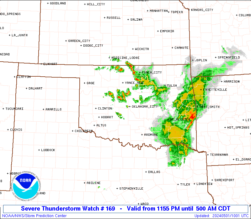
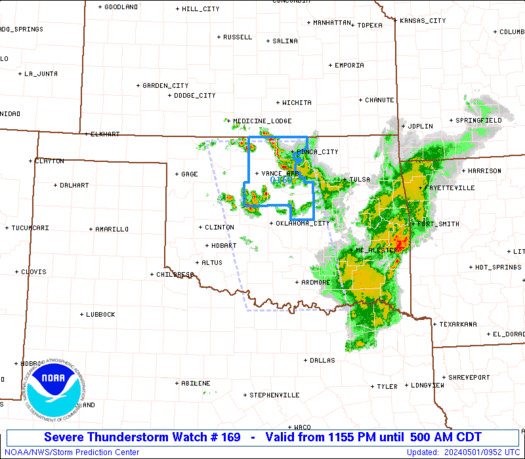
Severe Thunderstorm Watch Number 169
NWS Storm Prediction Center Norman OK
1155 PM CDT Tue Apr 30 2024
The NWS Storm Prediction Center has issued a
* Severe Thunderstorm Watch for portions of
Northern into Southern Oklahoma
North Texas
* Effective this Tuesday night and Wednesday morning from 1155 PM
until 500 AM CDT.
* Primary threats include...
Scattered large hail and isolated very large hail events to 2
inches in diameter possible
Scattered damaging wind gusts to 70 mph possible
SUMMARY...A few linear clusters of severe thunderstorms will likely
continue to into the overnight as a low-level jet is located over
the southern Plains. Severe gusts and large hail are possible with
the more intense thunderstorms.
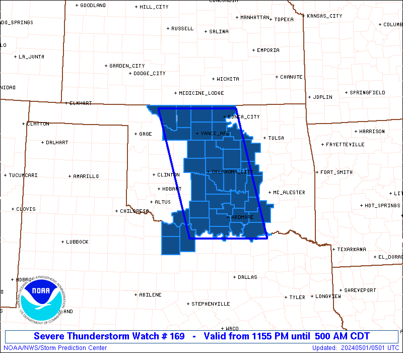
The severe thunderstorm watch area is approximately along and 65
statute miles east and west of a line from 40 miles north of Enid OK
to 35 miles south of Ardmore OK. For a complete depiction of the
watch see the associated watch outline update (WOUS64 KWNS WOU9).
PRECAUTIONARY/PREPAREDNESS ACTIONS...
REMEMBER...A Severe Thunderstorm Watch means conditions are
favorable for severe thunderstorms in and close to the watch area.
Persons in these areas should be on the lookout for threatening
weather conditions and listen for later statements and possible
warnings. Severe thunderstorms can and occasionally do produce
tornadoes.
&&
OTHER WATCH INFORMATION...CONTINUE...WW 167...WW 168...
AVIATION...A few severe thunderstorms with hail surface and aloft to
2 inches. Extreme turbulence and surface wind gusts to 60 knots. A
few cumulonimbi with maximum tops to 450. Mean storm motion vector
30025.
...Smith
 Note:
The Aviation Watch (SAW) product is an approximation to the watch area.
The actual watch is depicted by the shaded areas.
Note:
The Aviation Watch (SAW) product is an approximation to the watch area.
The actual watch is depicted by the shaded areas.
   SAW9
   WW 169 SEVERE TSTM OK TX 010455Z - 011000Z
   AXIS..65 STATUTE MILES EAST AND WEST OF LINE..
   40N END/ENID OK/ - 35S ADM/ARDMORE OK/
   ..AVIATION COORDS.. 55NM E/W /35N END - 27SSE ADM/
   HAIL SURFACE AND ALOFT..2 INCHES. WIND GUSTS..60 KNOTS.
   MAX TOPS TO 450. MEAN STORM MOTION VECTOR 30025.

   LAT...LON 36919674 33789589 33789815 36919910

   THIS IS AN APPROXIMATION TO THE WATCH AREA.  FOR A
   COMPLETE DEPICTION OF THE WATCH SEE WOUS64 KWNS
   FOR WOU9.
Watch 169 Status Report Messages:
STATUS REPORT #3 ON WW 169

VALID 010845Z - 010940Z

SEVERE WEATHER THREAT CONTINUES RIGHT OF A LINE FROM 30 NNW MLC
TO 15 SW CQB TO 10 NE END TO 40 ESE P28.

..LEITMAN..05/01/24

ATTN...WFO...OUN...TSA...

&&

STATUS REPORT FOR WS 169

SEVERE WEATHER THREAT CONTINUES FOR THE FOLLOWING AREAS

OKC037-047-053-071-081-103-107-117-119-010940-

OK
.    OKLAHOMA COUNTIES INCLUDED ARE

CREEK		     GARFIELD		 GRANT
KAY		     LINCOLN		 NOBLE
OKFUSKEE	     PAWNEE		 PAYNE
$$


THE WATCH STATUS MESSAGE IS FOR GUIDANCE PURPOSES ONLY.  PLEASE
REFER TO WATCH COUNTY NOTIFICATION STATEMENTS FOR OFFICIAL
INFORMATION ON COUNTIES...INDEPENDENT CITIES AND MARINE ZONES
CLEARED FROM SEVERE THUNDERSTORM AND TORNADO WATCHES.
$$

STATUS REPORT #2 ON WW 169

VALID 010740Z - 010840Z

SEVERE WEATHER THREAT CONTINUES RIGHT OF A LINE FROM 10 S DUA TO
45 W MLC TO 10 N END TO 35 ESE P28.

..LEITMAN..05/01/24

ATTN...WFO...OUN...TSA...

&&

STATUS REPORT FOR WS 169

SEVERE WEATHER THREAT CONTINUES FOR THE FOLLOWING AREAS

OKC005-013-029-037-047-053-063-071-081-083-103-107-117-119-133-
010840-

OK
.    OKLAHOMA COUNTIES INCLUDED ARE

ATOKA		     BRYAN		 COAL
CREEK		     GARFIELD		 GRANT
HUGHES		     KAY		 LINCOLN
LOGAN		     NOBLE		 OKFUSKEE
PAWNEE		     PAYNE		 SEMINOLE
$$


THE WATCH STATUS MESSAGE IS FOR GUIDANCE PURPOSES ONLY.  PLEASE
REFER TO WATCH COUNTY NOTIFICATION STATEMENTS FOR OFFICIAL
INFORMATION ON COUNTIES...INDEPENDENT CITIES AND MARINE ZONES
CLEARED FROM SEVERE THUNDERSTORM AND TORNADO WATCHES.
$$

STATUS REPORT #1 ON WW 169

VALID 010655Z - 010740Z

SEVERE WEATHER THREAT CONTINUES RIGHT OF A LINE FROM 55 SW ADM TO
20 SSE END TO 15 S P28.

..LEITMAN..05/01/24

ATTN...WFO...OUN...TSA...

&&

STATUS REPORT FOR WS 169

SEVERE WEATHER THREAT CONTINUES FOR THE FOLLOWING AREAS

OKC003-005-013-019-027-029-037-047-049-053-063-069-071-081-083-
085-087-095-099-103-107-109-117-119-123-125-133-010740-

OK
.    OKLAHOMA COUNTIES INCLUDED ARE

ALFALFA 	     ATOKA		 BRYAN
CARTER		     CLEVELAND		 COAL
CREEK		     GARFIELD		 GARVIN
GRANT		     HUGHES		 JOHNSTON
KAY		     LINCOLN		 LOGAN
LOVE		     MCCLAIN		 MARSHALL
MURRAY		     NOBLE		 OKFUSKEE
OKLAHOMA	     PAWNEE		 PAYNE
PONTOTOC	     POTTAWATOMIE	 SEMINOLE
$$


THE WATCH STATUS MESSAGE IS FOR GUIDANCE PURPOSES ONLY.  PLEASE
REFER TO WATCH COUNTY NOTIFICATION STATEMENTS FOR OFFICIAL
INFORMATION ON COUNTIES...INDEPENDENT CITIES AND MARINE ZONES
CLEARED FROM SEVERE THUNDERSTORM AND TORNADO WATCHES.
$$
Note:
Click for Complete Product Text.
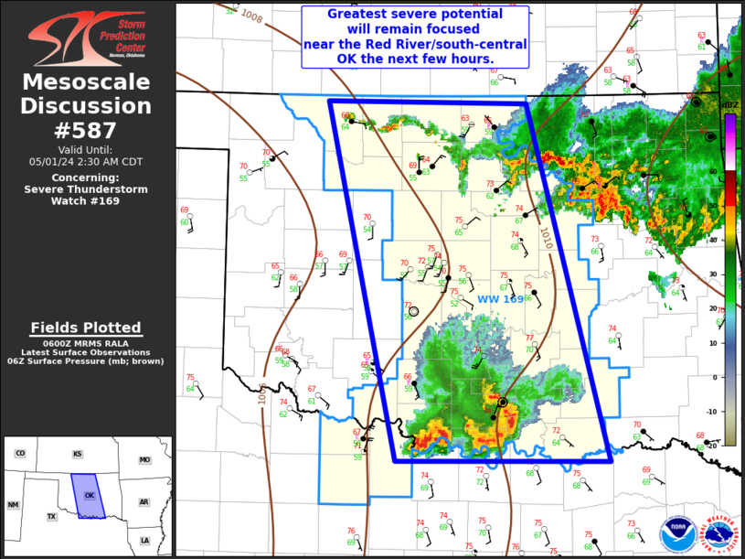
Tornadoes
Probability of 2 or more tornadoes
|
Low (10%)
|
Probability of 1 or more strong (EF2-EF5) tornadoes
|
Low (<2%)
|
Wind
Probability of 10 or more severe wind events
|
Mod (40%)
|
Probability of 1 or more wind events > 65 knots
|
Low (20%)
|
Hail
Probability of 10 or more severe hail events
|
Mod (40%)
|
Probability of 1 or more hailstones > 2 inches
|
Mod (30%)
|
Combined Severe Hail/Wind
Probability of 6 or more combined severe hail/wind events
|
High (70%)
|
For each watch, probabilities for particular events inside the watch
(listed above in each table) are determined by the issuing forecaster.
The "Low" category contains probability values ranging from less than 2%
to 20% (EF2-EF5 tornadoes), less than 5% to 20% (all other probabilities),
"Moderate" from 30% to 60%, and "High" from 70% to greater than 95%.
High values are bolded and lighter in color to provide awareness of
an increased threat for a particular event.


 @NWSSPC