 Note:
The expiration time in the watch graphic is amended if the watch is
replaced, cancelled or extended.
Note:
Note:
The expiration time in the watch graphic is amended if the watch is
replaced, cancelled or extended.
Note: Click for
Watch Status Reports.
SEL5
URGENT - IMMEDIATE BROADCAST REQUESTED
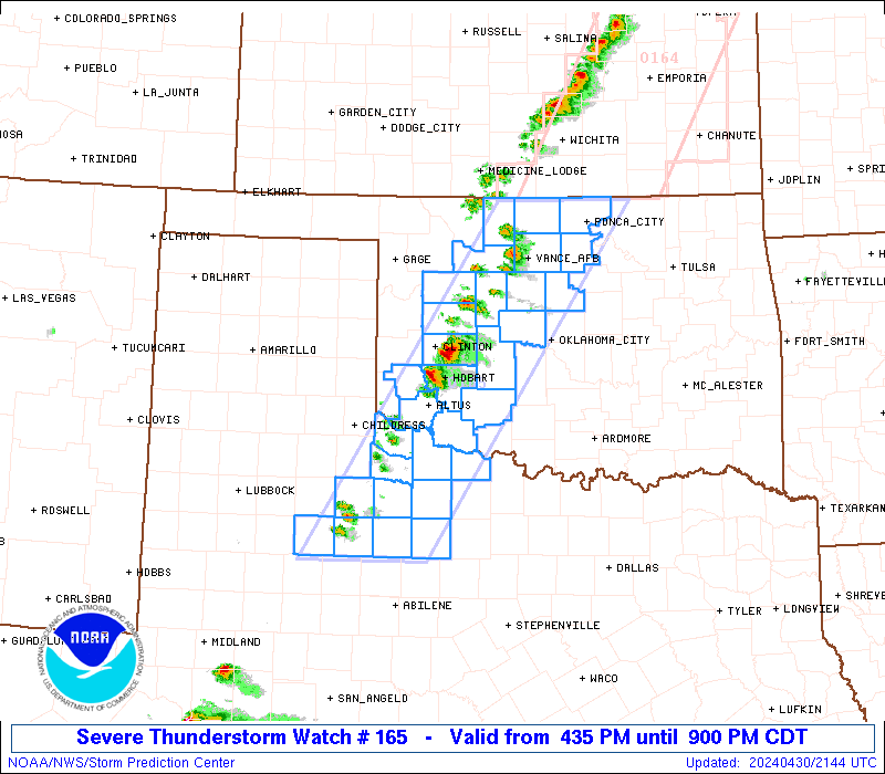
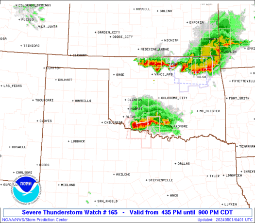
Severe Thunderstorm Watch Number 165
NWS Storm Prediction Center Norman OK
435 PM CDT Tue Apr 30 2024
The NWS Storm Prediction Center has issued a
* Severe Thunderstorm Watch for portions of
Northern and Western Oklahoma
Northwest Texas
* Effective this Tuesday afternoon and evening from 435 PM until
900 PM CDT.
* Primary threats include...
Scattered large hail and isolated very large hail events to 2.5
inches in diameter possible
Scattered damaging wind gusts to 70 mph possible
A tornado or two possible
SUMMARY...Widely scattered to scattered thunderstorms will likely
develop through the late afternoon into the early evening near and
east of the dryline. Some of the stronger storms will probably
become supercellular and pose a risk for large to very large hail
and severe gusts. A narrow window of time may exist for a brief
tornado towards the early evening mainly over the Oklahoma portion
of the Watch.
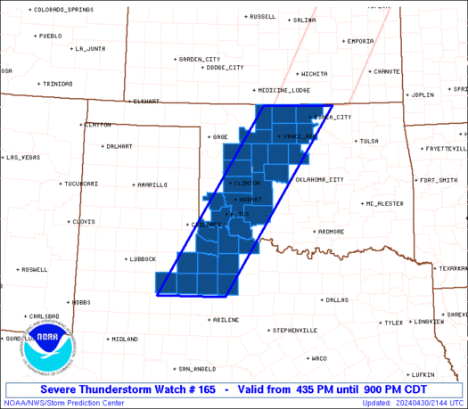
The severe thunderstorm watch area is approximately along and 50
statute miles east and west of a line from 25 miles northwest of
Ponca City OK to 130 miles south southwest of Altus OK. For a
complete depiction of the watch see the associated watch outline
update (WOUS64 KWNS WOU5).
PRECAUTIONARY/PREPAREDNESS ACTIONS...
REMEMBER...A Severe Thunderstorm Watch means conditions are
favorable for severe thunderstorms in and close to the watch area.
Persons in these areas should be on the lookout for threatening
weather conditions and listen for later statements and possible
warnings. Severe thunderstorms can and occasionally do produce
tornadoes.
&&
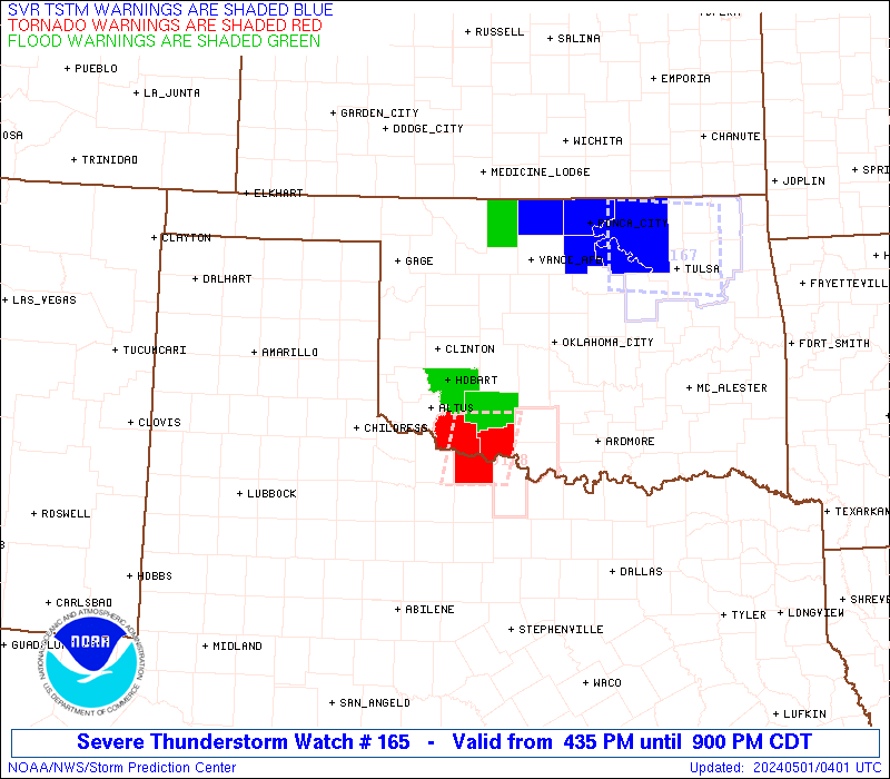
OTHER WATCH INFORMATION...CONTINUE...WW 163...WW 164...
AVIATION...A few severe thunderstorms with hail surface and aloft to
2.5 inches. Extreme turbulence and surface wind gusts to 60 knots. A
few cumulonimbi with maximum tops to 500. Mean storm motion vector
24020.
...Smith
 Note:
The Aviation Watch (SAW) product is an approximation to the watch area.
The actual watch is depicted by the shaded areas.
Note:
The Aviation Watch (SAW) product is an approximation to the watch area.
The actual watch is depicted by the shaded areas.
   SAW5
   WW 165 SEVERE TSTM OK TX 302135Z - 010200Z
   AXIS..50 STATUTE MILES EAST AND WEST OF LINE..
   25NW PNC/PONCA CITY OK/ - 130SSW LTS/ALTUS OK/
   ..AVIATION COORDS.. 45NM E/W /45NNE END - 29NNW ABI/
   HAIL SURFACE AND ALOFT..2.5 INCHES. WIND GUSTS..60 KNOTS.
   MAX TOPS TO 500. MEAN STORM MOTION VECTOR 24020.

   LAT...LON 36979651 32919927 32910099 36979833

   THIS IS AN APPROXIMATION TO THE WATCH AREA.  FOR A
   COMPLETE DEPICTION OF THE WATCH SEE WOUS64 KWNS
   FOR WOU5.
Watch 165 Status Report Messages:
STATUS REPORT #2 ON WW 165
VALID 010100Z - 010240Z
THE SEVERE WEATHER THREAT CONTINUES ACROSS THE ENTIRE WATCH AREA.
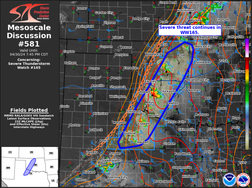
FOR ADDITIONAL INFORMATION SEE MESOSCALE DISCUSSION 581
..THORNTON..05/01/24
ATTN...WFO...OUN...SJT...LUB...
&&
STATUS REPORT FOR WS 165
SEVERE WEATHER THREAT CONTINUES FOR THE FOLLOWING AREAS
OKC003-011-015-017-031-039-043-047-053-055-065-071-073-075-083-
093-103-141-149-151-010240-
OK
. OKLAHOMA COUNTIES INCLUDED ARE
ALFALFA BLAINE CADDO
CANADIAN COMANCHE CUSTER
DEWEY GARFIELD GRANT
GREER JACKSON KAY
KINGFISHER KIOWA LOGAN
MAJOR NOBLE TILLMAN
WASHITA WOODS
$$
TXC023-155-197-207-263-269-275-433-447-485-487-010240-
TX
. TEXAS COUNTIES INCLUDED ARE
BAYLOR FOARD HARDEMAN
HASKELL KENT KING
KNOX STONEWALL THROCKMORTON
WICHITA WILBARGER
$$
THE WATCH STATUS MESSAGE IS FOR GUIDANCE PURPOSES ONLY. PLEASE
REFER TO WATCH COUNTY NOTIFICATION STATEMENTS FOR OFFICIAL
INFORMATION ON COUNTIES...INDEPENDENT CITIES AND MARINE ZONES
CLEARED FROM SEVERE THUNDERSTORM AND TORNADO WATCHES.
$$
STATUS REPORT #1 ON WW 165
VALID 302320Z - 010040Z
THE SEVERE WEATHER THREAT CONTINUES ACROSS THE ENTIRE WATCH AREA.
..THORNTON..04/30/24
ATTN...WFO...OUN...SJT...LUB...
&&
STATUS REPORT FOR WS 165
SEVERE WEATHER THREAT CONTINUES FOR THE FOLLOWING AREAS
OKC003-011-015-017-031-039-043-047-053-055-065-071-073-075-083-
093-103-141-149-010040-
OK
. OKLAHOMA COUNTIES INCLUDED ARE
ALFALFA BLAINE CADDO
CANADIAN COMANCHE CUSTER
DEWEY GARFIELD GRANT
GREER JACKSON KAY
KINGFISHER KIOWA LOGAN
MAJOR NOBLE TILLMAN
WASHITA
$$
TXC023-155-197-207-263-269-275-433-447-485-487-010040-
TX
. TEXAS COUNTIES INCLUDED ARE
BAYLOR FOARD HARDEMAN
HASKELL KENT KING
KNOX STONEWALL THROCKMORTON
WICHITA WILBARGER
$$
THE WATCH STATUS MESSAGE IS FOR GUIDANCE PURPOSES ONLY. PLEASE
REFER TO WATCH COUNTY NOTIFICATION STATEMENTS FOR OFFICIAL
INFORMATION ON COUNTIES...INDEPENDENT CITIES AND MARINE ZONES
CLEARED FROM SEVERE THUNDERSTORM AND TORNADO WATCHES.
$$
Note:
Click for Complete Product Text.
Tornadoes
Probability of 2 or more tornadoes
|
Low (20%)
|
Probability of 1 or more strong (EF2-EF5) tornadoes
|
Low (<2%)
|
Wind
Probability of 10 or more severe wind events
|
Mod (40%)
|
Probability of 1 or more wind events > 65 knots
|
Low (20%)
|
Hail
Probability of 10 or more severe hail events
|
Mod (40%)
|
Probability of 1 or more hailstones > 2 inches
|
Mod (30%)
|
Combined Severe Hail/Wind
Probability of 6 or more combined severe hail/wind events
|
High (70%)
|
For each watch, probabilities for particular events inside the watch
(listed above in each table) are determined by the issuing forecaster.
The "Low" category contains probability values ranging from less than 2%
to 20% (EF2-EF5 tornadoes), less than 5% to 20% (all other probabilities),
"Moderate" from 30% to 60%, and "High" from 70% to greater than 95%.
High values are bolded and lighter in color to provide awareness of
an increased threat for a particular event.


 @NWSSPC