 Note:
The expiration time in the watch graphic is amended if the watch is
replaced, cancelled or extended.
Note:
Note:
The expiration time in the watch graphic is amended if the watch is
replaced, cancelled or extended.
Note: Click for
Watch Status Reports.
SEL4
URGENT - IMMEDIATE BROADCAST REQUESTED
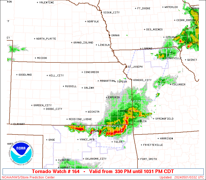
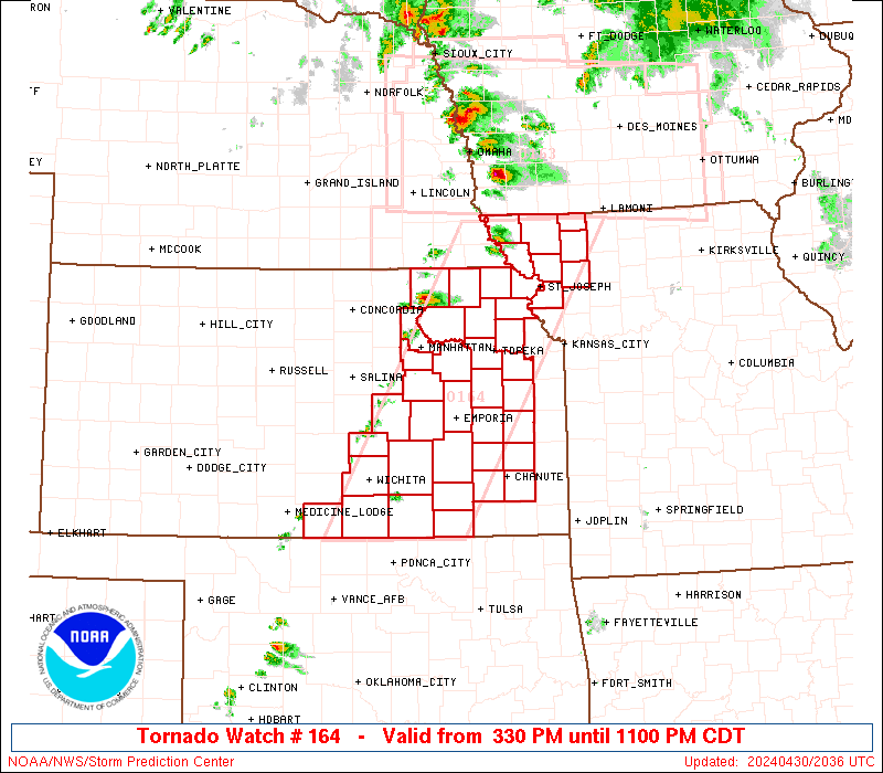
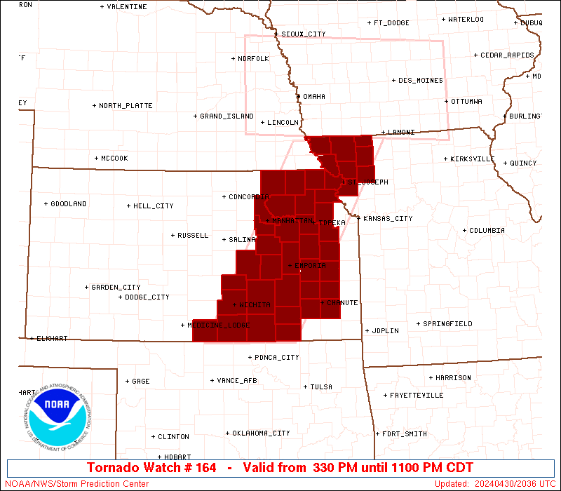
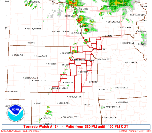
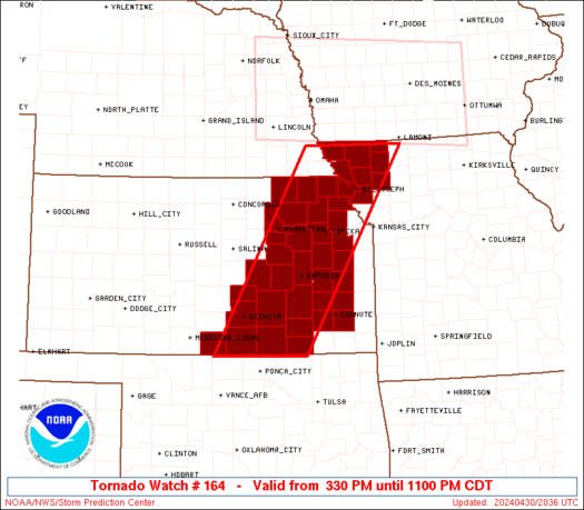
Tornado Watch Number 164
NWS Storm Prediction Center Norman OK
330 PM CDT Tue Apr 30 2024
The NWS Storm Prediction Center has issued a
* Tornado Watch for portions of
Eastern Kansas
Northwest Missouri
* Effective this Tuesday afternoon and evening from 330 PM until
1100 PM CDT.
* Primary threats include...
A few tornadoes possible
Scattered large hail and isolated very large hail events to 2.5
inches in diameter likely
Scattered damaging wind gusts to 70 mph likely
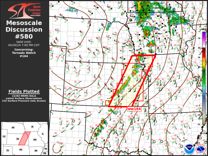
SUMMARY...Thunderstorms will develop this afternoon along a cold
front/dryline over eastern Kansas and drift eastward through the
afternoon and evening. Supercells capable of very large hail are
the main concern, although damaging winds and a tornado or two may
also occur.
The tornado watch area is approximately along and 55 statute miles
east and west of a line from 45 miles northeast of Falls City NE to
50 miles south southeast of Wichita KS. For a complete depiction of
the watch see the associated watch outline update (WOUS64 KWNS
WOU4).
PRECAUTIONARY/PREPAREDNESS ACTIONS...
REMEMBER...A Tornado Watch means conditions are favorable for
tornadoes and severe thunderstorms in and close to the watch
area. Persons in these areas should be on the lookout for
threatening weather conditions and listen for later statements
and possible warnings.
&&
OTHER WATCH INFORMATION...CONTINUE...WW 163...
AVIATION...Tornadoes and a few severe thunderstorms with hail
surface and aloft to 2.5 inches. Extreme turbulence and surface wind
gusts to 60 knots. A few cumulonimbi with maximum tops to 500. Mean
storm motion vector 26025.
...Hart
   SEL4

   URGENT - IMMEDIATE BROADCAST REQUESTED
   Tornado Watch Number 164
   NWS Storm Prediction Center Norman OK
   330 PM CDT Tue Apr 30 2024

   The NWS Storm Prediction Center has issued a

   * Tornado Watch for portions of
     Eastern Kansas
     Northwest Missouri

   * Effective this Tuesday afternoon and evening from 330 PM until
     1100 PM CDT.

   * Primary threats include...
     A few tornadoes possible
     Scattered large hail and isolated very large hail events to 2.5
       inches in diameter likely
     Scattered damaging wind gusts to 70 mph likely

   SUMMARY...Thunderstorms will develop this afternoon along a cold
   front/dryline over eastern Kansas and drift eastward through the
   afternoon and evening.  Supercells capable of very large hail are
   the main concern, although damaging winds and a tornado or two may
   also occur.

   The tornado watch area is approximately along and 55 statute miles
   east and west of a line from 45 miles northeast of Falls City NE to
   50 miles south southeast of Wichita KS. For a complete depiction of
   the watch see the associated watch outline update (WOUS64 KWNS
   WOU4).

   PRECAUTIONARY/PREPAREDNESS ACTIONS...

   REMEMBER...A Tornado Watch means conditions are favorable for
   tornadoes and severe thunderstorms in and close to the watch
   area. Persons in these areas should be on the lookout for
   threatening weather conditions and listen for later statements
   and possible warnings.

   &&

   OTHER WATCH INFORMATION...CONTINUE...WW 163...

   AVIATION...Tornadoes and a few severe thunderstorms with hail
   surface and aloft to 2.5 inches. Extreme turbulence and surface wind
   gusts to 60 knots. A few cumulonimbi with maximum tops to 500. Mean
   storm motion vector 26025.

   ...Hart
 Note:
The Aviation Watch (SAW) product is an approximation to the watch area.
The actual watch is depicted by the shaded areas.
Note:
The Aviation Watch (SAW) product is an approximation to the watch area.
The actual watch is depicted by the shaded areas.
   SAW4
   WW 164 TORNADO KS MO 302030Z - 010400Z
   AXIS..55 STATUTE MILES EAST AND WEST OF LINE..
   45NE FNB/FALLS CITY NE/ - 50SSE ICT/WICHITA KS/
   ..AVIATION COORDS.. 50NM E/W /51SE OVR - 52SSE ICT/
   HAIL SURFACE AND ALOFT..2.5 INCHES. WIND GUSTS..60 KNOTS.
   MAX TOPS TO 500. MEAN STORM MOTION VECTOR 26025.

   LAT...LON 40529395 36989609 36989808 40529604

   THIS IS AN APPROXIMATION TO THE WATCH AREA.  FOR A
   COMPLETE DEPICTION OF THE WATCH SEE WOUS64 KWNS
   FOR WOU4.
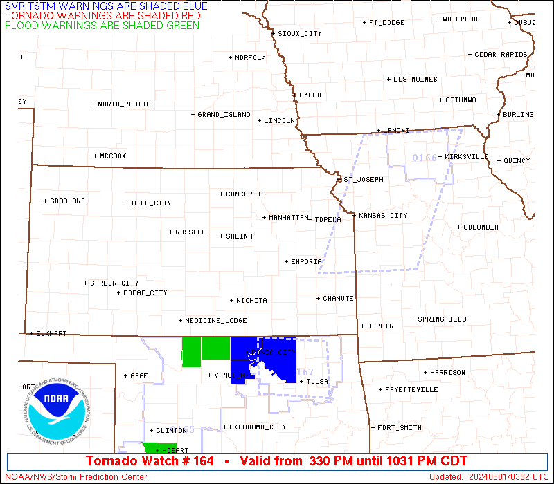
Watch 164 Status Report Messages:
STATUS REPORT #2 ON WW 164

VALID 010035Z - 010140Z

SEVERE WEATHER THREAT CONTINUES RIGHT OF A LINE FROM 25 WSW ICT
TO 30 ENE ICT TO 10 E EMP TO 15 E TOP TO 35 W LWD.

..SPC..05/01/24

ATTN...WFO...ICT...TOP...EAX...

&&

STATUS REPORT FOR WT 164

SEVERE WEATHER THREAT CONTINUES FOR THE FOLLOWING AREAS

KSC001-003-015-019-031-035-045-049-059-073-077-087-133-191-205-
207-010140-

KS
.    KANSAS COUNTIES INCLUDED ARE

ALLEN		     ANDERSON		 BUTLER
CHAUTAUQUA	     COFFEY		 COWLEY
DOUGLAS 	     ELK		 FRANKLIN
GREENWOOD	     HARPER		 JEFFERSON
NEOSHO		     SUMNER		 WILSON
WOODSON
$$


MOC075-227-010140-

MO
.    MISSOURI COUNTIES INCLUDED ARE

GENTRY		     WORTH
$$


THE WATCH STATUS MESSAGE IS FOR GUIDANCE PURPOSES ONLY.  PLEASE
REFER TO WATCH COUNTY NOTIFICATION STATEMENTS FOR OFFICIAL
INFORMATION ON COUNTIES...INDEPENDENT CITIES AND MARINE ZONES
CLEARED FROM SEVERE THUNDERSTORM AND TORNADO WATCHES.
$$

STATUS REPORT #1 ON WW 164

VALID 302350Z - 010040Z

SEVERE WEATHER THREAT CONTINUES RIGHT OF A LINE FROM 25 E HUT TO
25 NNW EMP TO 30 WSW STJ TO 25 SE SDA.

FOR ADDITIONAL INFORMATION SEE MESOSCALE DISCUSSION 580

..SMITH..04/30/24

ATTN...WFO...ICT...TOP...EAX...

&&

STATUS REPORT FOR WT 164

SEVERE WEATHER THREAT CONTINUES FOR THE FOLLOWING AREAS

KSC001-003-005-015-017-019-031-035-043-045-049-059-073-077-079-
085-087-111-115-133-139-173-177-191-205-207-010040-

KS
.    KANSAS COUNTIES INCLUDED ARE

ALLEN		     ANDERSON		 ATCHISON
BUTLER		     CHASE		 CHAUTAUQUA
COFFEY		     COWLEY		 DONIPHAN
DOUGLAS 	     ELK		 FRANKLIN
GREENWOOD	     HARPER		 HARVEY
JACKSON 	     JEFFERSON		 LYON
MARION		     NEOSHO		 OSAGE
SEDGWICK	     SHAWNEE		 SUMNER
WILSON		     WOODSON
$$


MOC003-021-063-075-087-147-227-010040-

MO
.    MISSOURI COUNTIES INCLUDED ARE

ANDREW		     BUCHANAN		 DEKALB
GENTRY		     HOLT		 NODAWAY
WORTH
$$


THE WATCH STATUS MESSAGE IS FOR GUIDANCE PURPOSES ONLY.  PLEASE
REFER TO WATCH COUNTY NOTIFICATION STATEMENTS FOR OFFICIAL
INFORMATION ON COUNTIES...INDEPENDENT CITIES AND MARINE ZONES
CLEARED FROM SEVERE THUNDERSTORM AND TORNADO WATCHES.
$$
Note:
Click for Complete Product Text.
Tornadoes
Probability of 2 or more tornadoes
|
Mod (50%)
|
Probability of 1 or more strong (EF2-EF5) tornadoes
|
Low (20%)
|
Wind
Probability of 10 or more severe wind events
|
High (70%)
|
Probability of 1 or more wind events > 65 knots
|
Low (10%)
|
Hail
Probability of 10 or more severe hail events
|
High (70%)
|
Probability of 1 or more hailstones > 2 inches
|
Mod (60%)
|
Combined Severe Hail/Wind
Probability of 6 or more combined severe hail/wind events
|
High (>95%)
|
For each watch, probabilities for particular events inside the watch
(listed above in each table) are determined by the issuing forecaster.
The "Low" category contains probability values ranging from less than 2%
to 20% (EF2-EF5 tornadoes), less than 5% to 20% (all other probabilities),
"Moderate" from 30% to 60%, and "High" from 70% to greater than 95%.
High values are bolded and lighter in color to provide awareness of
an increased threat for a particular event.


 @NWSSPC