Note:
The expiration time in the watch graphic is amended if the watch is
replaced, cancelled or extended.
Note:
Note:
The expiration time in the watch graphic is amended if the watch is
replaced, cancelled or extended.
Note: Click for
Watch Status Reports.
SEL3
URGENT - IMMEDIATE BROADCAST REQUESTED
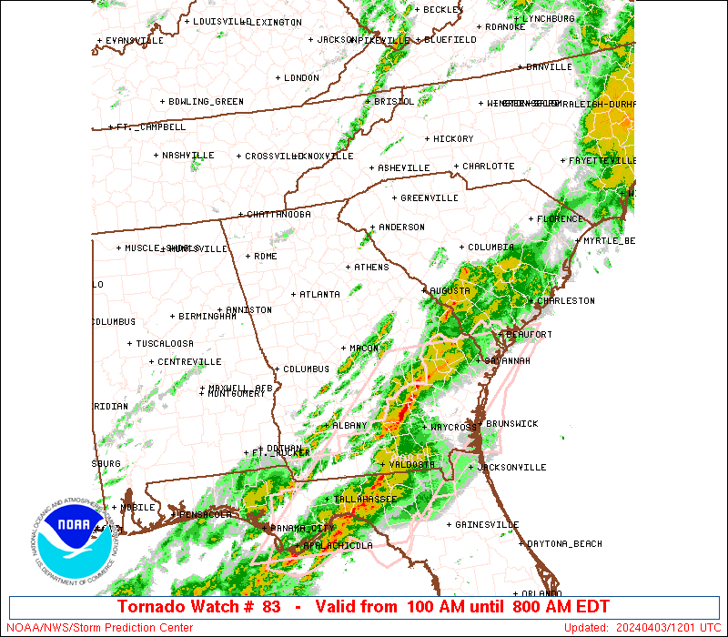
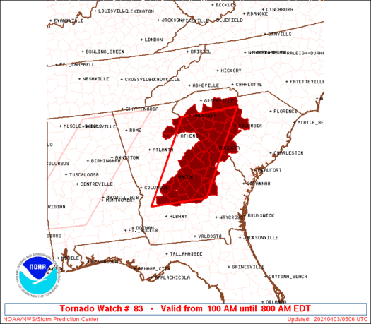
Tornado Watch Number 83
NWS Storm Prediction Center Norman OK
100 AM EDT Wed Apr 3 2024
The NWS Storm Prediction Center has issued a
* Tornado Watch for portions of
Eastern and South-Central Georgia
South Carolina
* Effective this Wednesday morning from 100 AM until 800 AM EDT.
* Primary threats include...
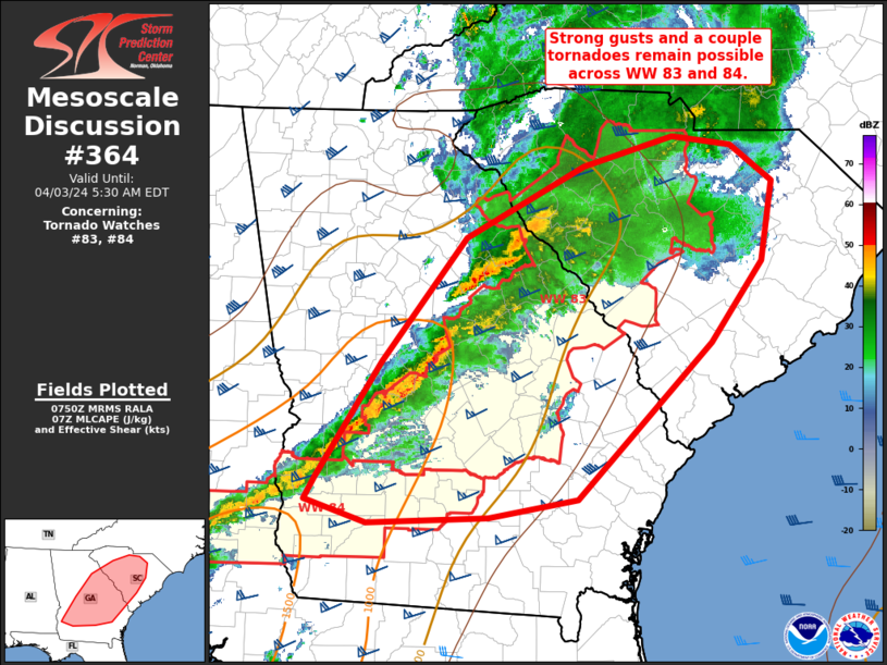
A few tornadoes and a couple intense tornadoes possible
Scattered damaging wind gusts to 70 mph possible
Isolated large hail events to 1.5 inches in diameter possible
SUMMARY...Storms are expected to strengthen and move into the region
overnight as an increasingly moist air mass spreads northeastward
regionally.
The tornado watch area is approximately along and 60 statute miles
east and west of a line from 80 miles north of Augusta GA to 55
miles south of Macon GA. For a complete depiction of the watch see
the associated watch outline update (WOUS64 KWNS WOU3).
PRECAUTIONARY/PREPAREDNESS ACTIONS...
REMEMBER...A Tornado Watch means conditions are favorable for
tornadoes and severe thunderstorms in and close to the watch
area. Persons in these areas should be on the lookout for
threatening weather conditions and listen for later statements
and possible warnings.
&&
OTHER WATCH INFORMATION...CONTINUE...WW 82...
AVIATION...Tornadoes and a few severe thunderstorms with hail
surface and aloft to 1.5 inches. Extreme turbulence and surface wind
gusts to 60 knots. A few cumulonimbi with maximum tops to 450. Mean
storm motion vector 24040.
...Guyer
 Note:
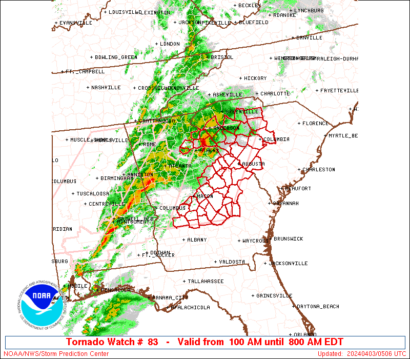
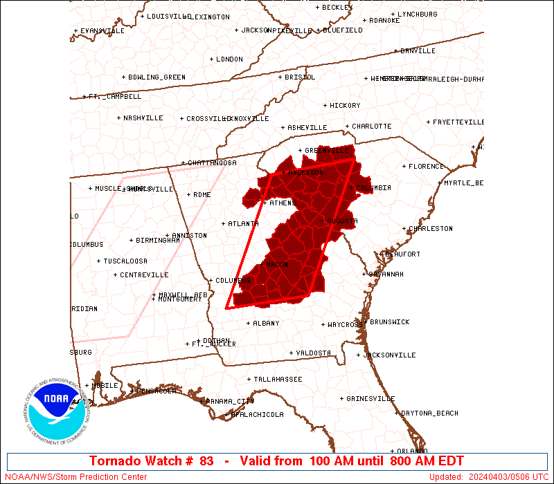
The Aviation Watch (SAW) product is an approximation to the watch area.
The actual watch is depicted by the shaded areas.
Note:
The Aviation Watch (SAW) product is an approximation to the watch area.
The actual watch is depicted by the shaded areas.
   SAW3
   WW 83 TORNADO GA SC 030500Z - 031200Z
   AXIS..60 STATUTE MILES EAST AND WEST OF LINE..
   80N AGS/AUGUSTA GA/ - 55S MCN/MACON GA/
   ..AVIATION COORDS.. 50NM E/W /31S SPA - 36ENE PZD/
   HAIL SURFACE AND ALOFT..1.5 INCHES. WIND GUSTS..60 KNOTS.
   MAX TOPS TO 450. MEAN STORM MOTION VECTOR 24040.

   LAT...LON 34508092 31908263 31908467 34508302

   THIS IS AN APPROXIMATION TO THE WATCH AREA.  FOR A
   COMPLETE DEPICTION OF THE WATCH SEE WOUS64 KWNS
   FOR WOU3.
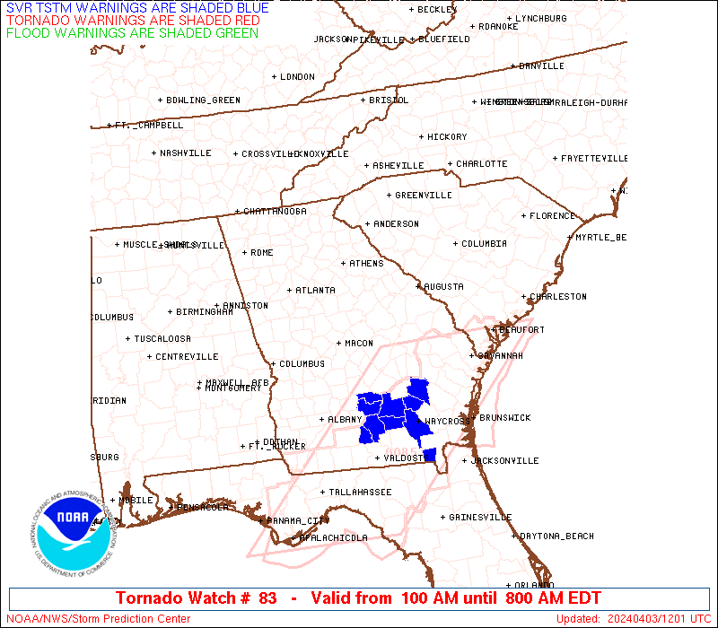
Watch 83 Status Report Messages:
STATUS REPORT #4 ON WW 83

VALID 031030Z - 031140Z

SEVERE WEATHER THREAT CONTINUES RIGHT OF A LINE FROM 50 ENE ABY
TO 30 NNW VDI TO 40 S AGS TO 45 S AGS.

..LEITMAN..04/03/24

ATTN...WFO...FFC...CAE...GSP...

&&

STATUS REPORT FOR WT 83

SEVERE WEATHER THREAT CONTINUES FOR THE FOLLOWING AREAS

GAC091-107-175-209-271-279-283-309-031140-

GA
.    GEORGIA COUNTIES INCLUDED ARE

DODGE		     EMANUEL		 LAURENS
MONTGOMERY	     TELFAIR		 TOOMBS
TREUTLEN	     WHEELER
$$


THE WATCH STATUS MESSAGE IS FOR GUIDANCE PURPOSES ONLY.  PLEASE
REFER TO WATCH COUNTY NOTIFICATION STATEMENTS FOR OFFICIAL
INFORMATION ON COUNTIES...INDEPENDENT CITIES AND MARINE ZONES
CLEARED FROM SEVERE THUNDERSTORM AND TORNADO WATCHES.
$$

STATUS REPORT #3 ON WW 83

VALID 030925Z - 031040Z

SEVERE WEATHER THREAT CONTINUES RIGHT OF A LINE FROM 25 NNE ABY
TO 40 ESE MCN TO 30 SSW AGS TO 10 ENE AGS TO 20 NW CAE TO 40 SSE
CLT.

..LEITMAN..04/03/24

ATTN...WFO...FFC...CAE...GSP...

&&

STATUS REPORT FOR WT 83

SEVERE WEATHER THREAT CONTINUES FOR THE FOLLOWING AREAS

GAC033-081-091-107-175-209-235-271-279-283-309-315-031040-

GA
.    GEORGIA COUNTIES INCLUDED ARE

BURKE		     CRISP		 DODGE
EMANUEL 	     LAURENS		 MONTGOMERY
PULASKI 	     TELFAIR		 TOOMBS
TREUTLEN	     WHEELER		 WILCOX
$$


SCC003-011-039-063-079-031040-

SC
.    SOUTH CAROLINA COUNTIES INCLUDED ARE

AIKEN		     BARNWELL		 FAIRFIELD
LEXINGTON	     RICHLAND
$$


THE WATCH STATUS MESSAGE IS FOR GUIDANCE PURPOSES ONLY.  PLEASE
REFER TO WATCH COUNTY NOTIFICATION STATEMENTS FOR OFFICIAL
INFORMATION ON COUNTIES...INDEPENDENT CITIES AND MARINE ZONES
CLEARED FROM SEVERE THUNDERSTORM AND TORNADO WATCHES.
$$

STATUS REPORT #2 ON WW 83

VALID 030835Z - 030940Z

SEVERE WEATHER THREAT CONTINUES RIGHT OF A LINE FROM 40 SSE CSG
TO 30 SSW MCN TO 15 ENE MCN TO 35 WNW AGS TO 40 NNW AGS TO 30 SW
CLT.

..LEITMAN..04/03/24

ATTN...WFO...FFC...CAE...GSP...

&&

STATUS REPORT FOR WT 83

SEVERE WEATHER THREAT CONTINUES FOR THE FOLLOWING AREAS

GAC023-033-073-081-091-093-107-125-153-163-167-175-181-189-209-
235-245-261-271-279-283-301-303-309-315-319-030940-

GA
.    GEORGIA COUNTIES INCLUDED ARE

BLECKLEY	     BURKE		 COLUMBIA
CRISP		     DODGE		 DOOLY
EMANUEL 	     GLASCOCK		 HOUSTON
JEFFERSON	     JOHNSON		 LAURENS
LINCOLN 	     MCDUFFIE		 MONTGOMERY
PULASKI 	     RICHMOND		 SUMTER
TELFAIR 	     TOOMBS		 TREUTLEN
WARREN		     WASHINGTON 	 WHEELER
WILCOX		     WILKINSON
$$


SCC003-011-023-037-039-047-063-071-079-081-030940-

SC
.    SOUTH CAROLINA COUNTIES INCLUDED ARE

AIKEN		     BARNWELL		 CHESTER
EDGEFIELD	     FAIRFIELD		 GREENWOOD
LEXINGTON	     NEWBERRY		 RICHLAND
SALUDA
$$


THE WATCH STATUS MESSAGE IS FOR GUIDANCE PURPOSES ONLY.  PLEASE
REFER TO WATCH COUNTY NOTIFICATION STATEMENTS FOR OFFICIAL
INFORMATION ON COUNTIES...INDEPENDENT CITIES AND MARINE ZONES
CLEARED FROM SEVERE THUNDERSTORM AND TORNADO WATCHES.
$$

STATUS REPORT #1 ON WW 83

VALID 030725Z - 030840Z

SEVERE WEATHER THREAT CONTINUES RIGHT OF A LINE FROM 25 SW AHN TO
30 ESE AND TO 10 SE GSP.

..LEITMAN..04/03/24

ATTN...WFO...FFC...CAE...GSP...

&&

STATUS REPORT FOR WT 83

SEVERE WEATHER THREAT CONTINUES FOR THE FOLLOWING AREAS

GAC009-023-033-073-081-091-093-105-107-125-141-153-163-167-175-
181-189-193-209-225-235-245-261-271-279-283-289-301-303-309-315-
319-030840-

GA
.    GEORGIA COUNTIES INCLUDED ARE

BALDWIN 	     BLECKLEY		 BURKE
COLUMBIA	     CRISP		 DODGE
DOOLY		     ELBERT		 EMANUEL
GLASCOCK	     HANCOCK		 HOUSTON
JEFFERSON	     JOHNSON		 LAURENS
LINCOLN 	     MCDUFFIE		 MACON
MONTGOMERY	     PEACH		 PULASKI
RICHMOND	     SUMTER		 TELFAIR
TOOMBS		     TREUTLEN		 TWIGGS
WARREN		     WASHINGTON 	 WHEELER
WILCOX		     WILKINSON
$$


SCC001-003-011-023-037-039-047-059-063-065-071-079-081-087-
030840-

SC
.    SOUTH CAROLINA COUNTIES INCLUDED ARE

ABBEVILLE	     AIKEN		 BARNWELL
CHESTER 	     EDGEFIELD		 FAIRFIELD
GREENWOOD	     LAURENS		 LEXINGTON
MCCORMICK	     NEWBERRY		 RICHLAND
SALUDA		     UNION
$$


THE WATCH STATUS MESSAGE IS FOR GUIDANCE PURPOSES ONLY.  PLEASE
REFER TO WATCH COUNTY NOTIFICATION STATEMENTS FOR OFFICIAL
INFORMATION ON COUNTIES...INDEPENDENT CITIES AND MARINE ZONES
CLEARED FROM SEVERE THUNDERSTORM AND TORNADO WATCHES.
$$
Note:
Click for Complete Product Text.
Tornadoes
Probability of 2 or more tornadoes
|
Mod (50%)
|
Probability of 1 or more strong (EF2-EF5) tornadoes
|
Mod (30%)
|
Wind
Probability of 10 or more severe wind events
|
Mod (50%)
|
Probability of 1 or more wind events > 65 knots
|
Low (10%)
|
Hail
Probability of 10 or more severe hail events
|
Low (20%)
|
Probability of 1 or more hailstones > 2 inches
|
Low (10%)
|
Combined Severe Hail/Wind
Probability of 6 or more combined severe hail/wind events
|
High (80%)
|
For each watch, probabilities for particular events inside the watch
(listed above in each table) are determined by the issuing forecaster.
The "Low" category contains probability values ranging from less than 2%
to 20% (EF2-EF5 tornadoes), less than 5% to 20% (all other probabilities),
"Moderate" from 30% to 60%, and "High" from 70% to greater than 95%.
High values are bolded and lighter in color to provide awareness of
an increased threat for a particular event.


 @NWSSPC