 Note:
The expiration time in the watch graphic is amended if the watch is
replaced, cancelled or extended.
Note:
Note:
The expiration time in the watch graphic is amended if the watch is
replaced, cancelled or extended.
Note: Click for
Watch Status Reports.
SEL2
URGENT - IMMEDIATE BROADCAST REQUESTED
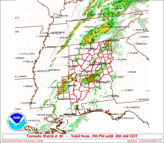
Tornado Watch Number 82
NWS Storm Prediction Center Norman OK
700 PM CDT Tue Apr 2 2024
The NWS Storm Prediction Center has issued a
* Tornado Watch for portions of
Alabama
Northwest Georgia
Eastern Mississippi
* Effective this Tuesday night and Wednesday morning from 700 PM
until 200 AM CDT.
* Primary threats include...
A few tornadoes likely with a couple intense tornadoes possible
Scattered damaging wind gusts to 65 mph likely
Scattered large hail events to 1.5 inches in diameter possible
SUMMARY...Storms, including supercells, are expected to intensify
across the region this evening. Tornado potential will steadily
increase after sunset as a low-level jet considerably strengthens.
The tornado watch area is approximately along and 75 statute miles
east and west of a line from 40 miles north northwest of Rome GA to
55 miles south southeast of Meridian MS. For a complete depiction of
the watch see the associated watch outline update (WOUS64 KWNS
WOU2).
PRECAUTIONARY/PREPAREDNESS ACTIONS...
REMEMBER...A Tornado Watch means conditions are favorable for
tornadoes and severe thunderstorms in and close to the watch
area. Persons in these areas should be on the lookout for
threatening weather conditions and listen for later statements
and possible warnings.
&&
OTHER WATCH INFORMATION...CONTINUE...WW 77...WW 78...WW 79...WW
80...WW 81...
AVIATION...Tornadoes and a few severe thunderstorms with hail
surface and aloft to 1.5 inches. Extreme turbulence and surface wind
gusts to 55 knots. A few cumulonimbi with maximum tops to 500. Mean
storm motion vector 24040.
...Guyer
   SEL2

   URGENT - IMMEDIATE BROADCAST REQUESTED
   Tornado Watch Number 82
   NWS Storm Prediction Center Norman OK
   700 PM CDT Tue Apr 2 2024

   The NWS Storm Prediction Center has issued a

   * Tornado Watch for portions of
     Alabama
     Northwest Georgia
     Eastern Mississippi

   * Effective this Tuesday night and Wednesday morning from 700 PM
     until 200 AM CDT.

   * Primary threats include...
     A few tornadoes likely with a couple intense tornadoes possible
     Scattered damaging wind gusts to 65 mph likely
     Scattered large hail events to 1.5 inches in diameter possible

   SUMMARY...Storms, including supercells, are expected to intensify
   across the region this evening. Tornado potential will steadily
   increase after sunset as a low-level jet considerably strengthens.

   The tornado watch area is approximately along and 75 statute miles
   east and west of a line from 40 miles north northwest of Rome GA to
   55 miles south southeast of Meridian MS. For a complete depiction of
   the watch see the associated watch outline update (WOUS64 KWNS
   WOU2).

   PRECAUTIONARY/PREPAREDNESS ACTIONS...

   REMEMBER...A Tornado Watch means conditions are favorable for
   tornadoes and severe thunderstorms in and close to the watch
   area. Persons in these areas should be on the lookout for
   threatening weather conditions and listen for later statements
   and possible warnings.

   &&

   OTHER WATCH INFORMATION...CONTINUE...WW 77...WW 78...WW 79...WW
   80...WW 81...

   AVIATION...Tornadoes and a few severe thunderstorms with hail
   surface and aloft to 1.5 inches. Extreme turbulence and surface wind
   gusts to 55 knots. A few cumulonimbi with maximum tops to 500. Mean
   storm motion vector 24040.

   ...Guyer
 Note:
The Aviation Watch (SAW) product is an approximation to the watch area.
The actual watch is depicted by the shaded areas.
Note:
The Aviation Watch (SAW) product is an approximation to the watch area.
The actual watch is depicted by the shaded areas.
   SAW2
   WW 82 TORNADO AL GA MS 030000Z - 030700Z
   AXIS..75 STATUTE MILES EAST AND WEST OF LINE..
   40NNW RMG/ROME GA/ - 55SSE MEI/MERIDIAN MS/
   ..AVIATION COORDS.. 65NM E/W /15WSW GQO - 52SSE MEI/
   HAIL SURFACE AND ALOFT..1.5 INCHES. WIND GUSTS..55 KNOTS.
   MAX TOPS TO 500. MEAN STORM MOTION VECTOR 24040.

   LAT...LON 34888412 31598712 31598967 34888676

   THIS IS AN APPROXIMATION TO THE WATCH AREA.  FOR A
   COMPLETE DEPICTION OF THE WATCH SEE WOUS64 KWNS
   FOR WOU2.
Watch 82 Status Report Messages:
STATUS REPORT #6 ON WW 82

VALID 030540Z - 030640Z

SEVERE WEATHER THREAT CONTINUES RIGHT OF A LINE FROM 40 WSW GZH
TO 15 N MGM TO 20 NNW AUO TO 10 WNW ATL TO 30 NE ATL.

..LEITMAN..04/03/24

ATTN...WFO...BMX...MOB...HUN...FFC...JAN...

&&

STATUS REPORT FOR WT 82

SEVERE WEATHER THREAT CONTINUES FOR THE FOLLOWING AREAS

ALC005-011-013-017-035-039-041-051-053-081-087-101-109-113-
030640-

AL
.    ALABAMA COUNTIES INCLUDED ARE

BARBOUR 	     BULLOCK		 BUTLER
CHAMBERS	     CONECUH		 COVINGTON
CRENSHAW	     ELMORE		 ESCAMBIA
LEE		     MACON		 MONTGOMERY
PIKE		     RUSSELL
$$


GAC021-035-053-059-063-077-079-089-113-121-133-145-149-151-159-
169-171-197-199-207-211-215-217-219-221-231-237-247-249-255-259-
263-265-269-285-293-297-307-317-030640-

GA
.    GEORGIA COUNTIES INCLUDED ARE

BIBB		     BUTTS		 CHATTAHOOCHEE
CLARKE		     CLAYTON		 COWETA
CRAWFORD	     DEKALB		 FAYETTE
FULTON		     GREENE		 HARRIS
HEARD		     HENRY		 JASPER
JONES		     LAMAR		 MARION
MERIWETHER	     MONROE		 MORGAN
MUSCOGEE	     NEWTON		 OCONEE
OGLETHORPE	     PIKE		 PUTNAM
ROCKDALE	     SCHLEY		 SPALDING
STEWART 	     TALBOT		 TALIAFERRO
TAYLOR		     TROUP		 UPSON
WALTON		     WEBSTER		 WILKES
$$


THE WATCH STATUS MESSAGE IS FOR GUIDANCE PURPOSES ONLY.  PLEASE
REFER TO WATCH COUNTY NOTIFICATION STATEMENTS FOR OFFICIAL
INFORMATION ON COUNTIES...INDEPENDENT CITIES AND MARINE ZONES
CLEARED FROM SEVERE THUNDERSTORM AND TORNADO WATCHES.
$$

STATUS REPORT #5 ON WW 82

VALID 030445Z - 030540Z

SEVERE WEATHER THREAT CONTINUES RIGHT OF A LINE FROM 45 NNE MOB
TO 30 NW GZH TO 20 NE SEM TO 35 SW ANB TO 35 S RMG TO 35 N ATL.

..BENTLEY..04/03/24

ATTN...WFO...BMX...MOB...HUN...FFC...JAN...

&&

STATUS REPORT FOR WT 82

SEVERE WEATHER THREAT CONTINUES FOR THE FOLLOWING AREAS

ALC001-005-011-017-027-037-047-051-081-085-087-099-101-109-111-
113-123-131-030540-

AL
.    ALABAMA COUNTIES INCLUDED ARE

AUTAUGA 	     BARBOUR		 BULLOCK
CHAMBERS	     CLAY		 COOSA
DALLAS		     ELMORE		 LEE
LOWNDES 	     MACON		 MONROE
MONTGOMERY	     PIKE		 RANDOLPH
RUSSELL 	     TALLAPOOSA 	 WILCOX
$$


GAC021-035-045-053-059-063-067-077-079-089-097-113-121-133-143-
145-149-151-159-169-171-197-199-207-211-215-217-219-221-223-231-
237-247-249-255-259-263-265-269-285-293-297-307-317-030540-

GA
.    GEORGIA COUNTIES INCLUDED ARE

BIBB		     BUTTS		 CARROLL
CHATTAHOOCHEE	     CLARKE		 CLAYTON
COBB		     COWETA		 CRAWFORD
DEKALB		     DOUGLAS		 FAYETTE
FULTON		     GREENE		 HARALSON
HARRIS		     HEARD		 HENRY
JASPER		     JONES		 LAMAR
MARION		     MERIWETHER 	 MONROE
MORGAN		     MUSCOGEE		 NEWTON
OCONEE		     OGLETHORPE 	 PAULDING
PIKE		     PUTNAM		 ROCKDALE
SCHLEY		     SPALDING		 STEWART
TALBOT		     TALIAFERRO 	 TAYLOR
TROUP		     UPSON		 WALTON
WEBSTER 	     WILKES
$$


THE WATCH STATUS MESSAGE IS FOR GUIDANCE PURPOSES ONLY.  PLEASE
REFER TO WATCH COUNTY NOTIFICATION STATEMENTS FOR OFFICIAL
INFORMATION ON COUNTIES...INDEPENDENT CITIES AND MARINE ZONES
CLEARED FROM SEVERE THUNDERSTORM AND TORNADO WATCHES.
$$

STATUS REPORT #4 ON WW 82

VALID 030310Z - 030440Z

SEVERE WEATHER THREAT CONTINUES RIGHT OF A LINE FROM 50 E PIB TO
35 ESE MEI TO 25 SSE TCL TO 25 NE BHM TO 25 WNW CHA.

..BENTLEY..04/03/24

ATTN...WFO...BMX...MOB...HUN...FFC...JAN...

&&

STATUS REPORT FOR WT 82

SEVERE WEATHER THREAT CONTINUES FOR THE FOLLOWING AREAS

ALC001-007-015-017-019-021-023-025-027-029-037-047-049-051-055-
065-071-073-085-091-095-099-101-105-111-115-117-121-123-129-131-
030440-

AL
.    ALABAMA COUNTIES INCLUDED ARE

AUTAUGA 	     BIBB		 CALHOUN
CHAMBERS	     CHEROKEE		 CHILTON
CHOCTAW 	     CLARKE		 CLAY
CLEBURNE	     COOSA		 DALLAS
DEKALB		     ELMORE		 ETOWAH
HALE		     JACKSON		 JEFFERSON
LOWNDES 	     MARENGO		 MARSHALL
MONROE		     MONTGOMERY 	 PERRY
RANDOLPH	     ST. CLAIR		 SHELBY
TALLADEGA	     TALLAPOOSA 	 WASHINGTON
WILCOX
$$


GAC015-045-047-055-057-063-067-077-083-089-097-113-115-121-129-
143-149-151-199-213-223-231-233-255-285-295-313-030440-

GA
.    GEORGIA COUNTIES INCLUDED ARE

BARTOW		     CARROLL		 CATOOSA
CHATTOOGA	     CHEROKEE		 CLAYTON
COBB		     COWETA		 DADE
DEKALB		     DOUGLAS		 FAYETTE
FLOYD		     FULTON		 GORDON
HARALSON	     HEARD		 HENRY
MERIWETHER	     MURRAY		 PAULDING
PIKE		     POLK		 SPALDING
TROUP		     WALKER		 WHITFIELD
$$


THE WATCH STATUS MESSAGE IS FOR GUIDANCE PURPOSES ONLY.  PLEASE
REFER TO WATCH COUNTY NOTIFICATION STATEMENTS FOR OFFICIAL
INFORMATION ON COUNTIES...INDEPENDENT CITIES AND MARINE ZONES
CLEARED FROM SEVERE THUNDERSTORM AND TORNADO WATCHES.
$$

STATUS REPORT #3 ON WW 82

VALID 030205Z - 030340Z

SEVERE WEATHER THREAT CONTINUES RIGHT OF A LINE FROM 20 ESE PIB
TO 20 S MEI TO 30 SSW TCL TO 20 SSE HSV TO 45 NE HSV.

..BENTLEY..04/03/24

ATTN...WFO...BMX...MOB...HUN...FFC...JAN...

&&

STATUS REPORT FOR WT 82

SEVERE WEATHER THREAT CONTINUES FOR THE FOLLOWING AREAS

ALC001-007-009-015-017-019-021-023-025-027-029-037-043-047-049-
051-055-063-065-071-073-085-091-095-099-101-105-111-115-117-119-
121-123-125-127-129-131-030340-

AL
.    ALABAMA COUNTIES INCLUDED ARE

AUTAUGA 	     BIBB		 BLOUNT
CALHOUN 	     CHAMBERS		 CHEROKEE
CHILTON 	     CHOCTAW		 CLARKE
CLAY		     CLEBURNE		 COOSA
CULLMAN 	     DALLAS		 DEKALB
ELMORE		     ETOWAH		 GREENE
HALE		     JACKSON		 JEFFERSON
LOWNDES 	     MARENGO		 MARSHALL
MONROE		     MONTGOMERY 	 PERRY
RANDOLPH	     ST. CLAIR		 SHELBY
SUMTER		     TALLADEGA		 TALLAPOOSA
TUSCALOOSA	     WALKER		 WASHINGTON
WILCOX
$$


GAC015-045-047-055-083-097-115-129-143-149-213-223-233-285-295-
313-030340-

GA
.    GEORGIA COUNTIES INCLUDED ARE

BARTOW		     CARROLL		 CATOOSA
CHATTOOGA	     DADE		 DOUGLAS
FLOYD		     GORDON		 HARALSON
HEARD		     MURRAY		 PAULDING
POLK		     TROUP		 WALKER
WHITFIELD
$$


MSC153-030340-

MS
.    MISSISSIPPI COUNTIES INCLUDED ARE

WAYNE
$$


THE WATCH STATUS MESSAGE IS FOR GUIDANCE PURPOSES ONLY.  PLEASE
REFER TO WATCH COUNTY NOTIFICATION STATEMENTS FOR OFFICIAL
INFORMATION ON COUNTIES...INDEPENDENT CITIES AND MARINE ZONES
CLEARED FROM SEVERE THUNDERSTORM AND TORNADO WATCHES.
$$

STATUS REPORT #2 ON WW 82

VALID 030125Z - 030240Z

THE SEVERE WEATHER THREAT CONTINUES ACROSS THE ENTIRE WATCH AREA.

..BENTLEY..04/03/24

ATTN...WFO...BMX...MOB...HUN...FFC...JAN...

&&

STATUS REPORT FOR WT 82

SEVERE WEATHER THREAT CONTINUES FOR THE FOLLOWING AREAS

ALC001-007-009-015-017-019-021-023-025-027-029-037-043-047-049-
051-055-057-063-065-071-073-075-085-091-093-095-099-101-105-107-
111-115-117-119-121-123-125-127-129-131-133-030240-

AL
.    ALABAMA COUNTIES INCLUDED ARE

AUTAUGA 	     BIBB		 BLOUNT
CALHOUN 	     CHAMBERS		 CHEROKEE
CHILTON 	     CHOCTAW		 CLARKE
CLAY		     CLEBURNE		 COOSA
CULLMAN 	     DALLAS		 DEKALB
ELMORE		     ETOWAH		 FAYETTE
GREENE		     HALE		 JACKSON
JEFFERSON	     LAMAR		 LOWNDES
MARENGO 	     MARION		 MARSHALL
MONROE		     MONTGOMERY 	 PERRY
PICKENS 	     RANDOLPH		 ST. CLAIR
SHELBY		     SUMTER		 TALLADEGA
TALLAPOOSA	     TUSCALOOSA 	 WALKER
WASHINGTON	     WILCOX		 WINSTON
$$


GAC015-045-047-055-083-097-115-129-143-149-213-223-233-285-295-
313-030240-

GA
.    GEORGIA COUNTIES INCLUDED ARE

BARTOW		     CARROLL		 CATOOSA
CHATTOOGA	     DADE		 DOUGLAS
FLOYD		     GORDON		 HARALSON
HEARD		     MURRAY		 PAULDING
POLK		     TROUP		 WALKER
WHITFIELD
$$


MSC023-061-067-069-075-101-153-030240-

MS
.    MISSISSIPPI COUNTIES INCLUDED ARE

CLARKE		     JASPER		 JONES
KEMPER		     LAUDERDALE 	 NEWTON
WAYNE
$$


THE WATCH STATUS MESSAGE IS FOR GUIDANCE PURPOSES ONLY.  PLEASE
REFER TO WATCH COUNTY NOTIFICATION STATEMENTS FOR OFFICIAL
INFORMATION ON COUNTIES...INDEPENDENT CITIES AND MARINE ZONES
CLEARED FROM SEVERE THUNDERSTORM AND TORNADO WATCHES.
$$

STATUS REPORT #1 ON WW 82

VALID 030025Z - 030140Z

THE SEVERE WEATHER THREAT CONTINUES ACROSS THE ENTIRE WATCH AREA.

..LYONS..04/03/24

ATTN...WFO...BMX...MOB...HUN...FFC...JAN...

&&

STATUS REPORT FOR WT 82

SEVERE WEATHER THREAT CONTINUES FOR THE FOLLOWING AREAS

ALC001-007-009-015-017-019-021-023-025-027-029-037-043-047-049-
051-055-057-063-065-071-073-075-085-091-093-095-099-101-105-107-
111-115-117-119-121-123-125-127-129-131-133-030140-

AL
.    ALABAMA COUNTIES INCLUDED ARE

AUTAUGA 	     BIBB		 BLOUNT
CALHOUN 	     CHAMBERS		 CHEROKEE
CHILTON 	     CHOCTAW		 CLARKE
CLAY		     CLEBURNE		 COOSA
CULLMAN 	     DALLAS		 DEKALB
ELMORE		     ETOWAH		 FAYETTE
GREENE		     HALE		 JACKSON
JEFFERSON	     LAMAR		 LOWNDES
MARENGO 	     MARION		 MARSHALL
MONROE		     MONTGOMERY 	 PERRY
PICKENS 	     RANDOLPH		 ST. CLAIR
SHELBY		     SUMTER		 TALLADEGA
TALLAPOOSA	     TUSCALOOSA 	 WALKER
WASHINGTON	     WILCOX		 WINSTON
$$


GAC015-045-047-055-083-097-115-129-143-149-213-223-233-285-295-
313-030140-

GA
.    GEORGIA COUNTIES INCLUDED ARE

BARTOW		     CARROLL		 CATOOSA
CHATTOOGA	     DADE		 DOUGLAS
FLOYD		     GORDON		 HARALSON
HEARD		     MURRAY		 PAULDING
POLK		     TROUP		 WALKER
WHITFIELD
$$


MSC023-061-067-069-075-101-153-030140-

MS
.    MISSISSIPPI COUNTIES INCLUDED ARE

CLARKE		     JASPER		 JONES
KEMPER		     LAUDERDALE 	 NEWTON
WAYNE
$$


THE WATCH STATUS MESSAGE IS FOR GUIDANCE PURPOSES ONLY.  PLEASE
REFER TO WATCH COUNTY NOTIFICATION STATEMENTS FOR OFFICIAL
INFORMATION ON COUNTIES...INDEPENDENT CITIES AND MARINE ZONES
CLEARED FROM SEVERE THUNDERSTORM AND TORNADO WATCHES.
$$
Note:
Click for Complete Product Text.
Tornadoes
Probability of 2 or more tornadoes
|
High (70%)
|
Probability of 1 or more strong (EF2-EF5) tornadoes
|
Mod (50%)
|
Wind
Probability of 10 or more severe wind events
|
Mod (60%)
|
Probability of 1 or more wind events > 65 knots
|
Low (20%)
|
Hail
Probability of 10 or more severe hail events
|
Mod (50%)
|
Probability of 1 or more hailstones > 2 inches
|
Low (20%)
|
Combined Severe Hail/Wind
Probability of 6 or more combined severe hail/wind events
|
High (90%)
|
For each watch, probabilities for particular events inside the watch
(listed above in each table) are determined by the issuing forecaster.
The "Low" category contains probability values ranging from less than 2%
to 20% (EF2-EF5 tornadoes), less than 5% to 20% (all other probabilities),
"Moderate" from 30% to 60%, and "High" from 70% to greater than 95%.
High values are bolded and lighter in color to provide awareness of
an increased threat for a particular event.


 @NWSSPC


