Note:
The expiration time in the watch graphic is amended if the watch is
replaced, cancelled or extended.
Note:
Note:
The expiration time in the watch graphic is amended if the watch is
replaced, cancelled or extended.
Note: Click for
Watch Status Reports.
SEL6
URGENT - IMMEDIATE BROADCAST REQUESTED
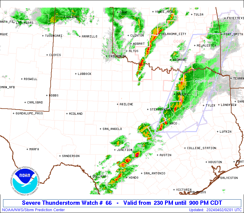
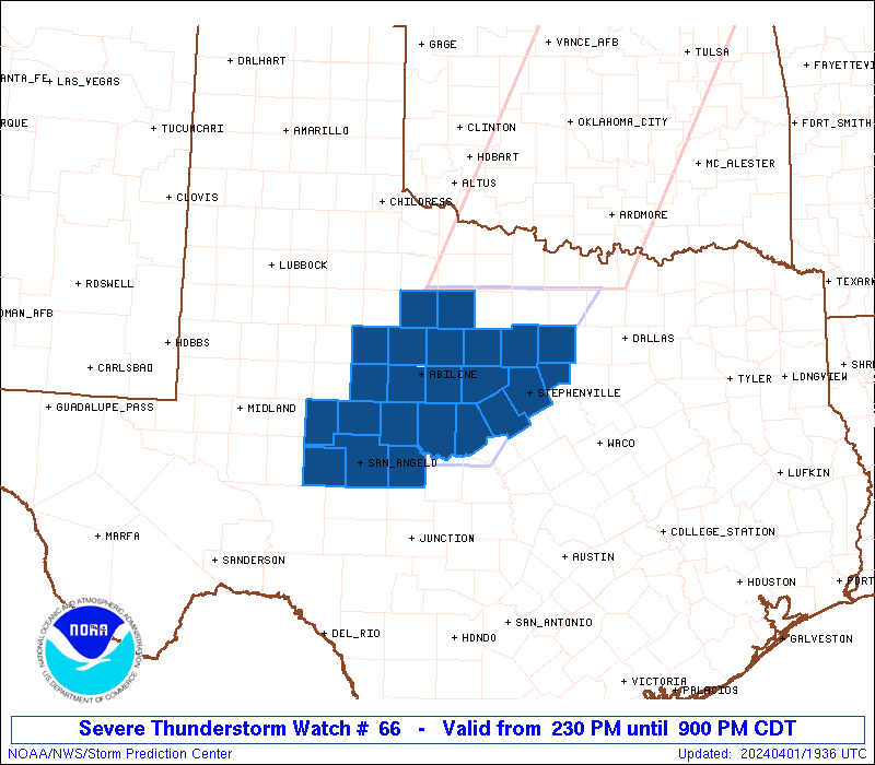
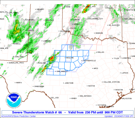
Severe Thunderstorm Watch Number 66
NWS Storm Prediction Center Norman OK
230 PM CDT Mon Apr 1 2024
The NWS Storm Prediction Center has issued a
* Severe Thunderstorm Watch for portions of
Parts of central and northwest Texas
* Effective this Monday afternoon and evening from 230 PM until
900 PM CDT.
* Primary threats include...
Scattered large hail and isolated very large hail events to 3
inches in diameter possible
Isolated damaging wind gusts to 70 mph possible
SUMMARY...Scattered severe storms are expected to form this
afternoon along a dryline in west central Texas, and storms will
spread east-northeastward through this evening. Supercells with
very large hail (2-3 inch diameter) and isolated damaging gusts
(60-70 mph) will be the main threats.
The severe thunderstorm watch area is approximately along and 70
statute miles east and west of a line from 50 miles north northwest
of Mineral Wells TX to 35 miles east of San Angelo TX. For a
complete depiction of the watch see the associated watch outline
update (WOUS64 KWNS WOU6).
PRECAUTIONARY/PREPAREDNESS ACTIONS...
REMEMBER...A Severe Thunderstorm Watch means conditions are
favorable for severe thunderstorms in and close to the watch area.
Persons in these areas should be on the lookout for threatening
weather conditions and listen for later statements and possible
warnings. Severe thunderstorms can and occasionally do produce
tornadoes.
&&
OTHER WATCH INFORMATION...CONTINUE...WW 64...WW 65...
AVIATION...A few severe thunderstorms with hail surface and aloft to
3 inches. Extreme turbulence and surface wind gusts to 60 knots. A
few cumulonimbi with maximum tops to 550. Mean storm motion vector
24040.
...Thompson
   SEL6

   URGENT - IMMEDIATE BROADCAST REQUESTED
   Severe Thunderstorm Watch Number 66
   NWS Storm Prediction Center Norman OK
   230 PM CDT Mon Apr 1 2024

   The NWS Storm Prediction Center has issued a

   * Severe Thunderstorm Watch for portions of
     Parts of central and northwest Texas

   * Effective this Monday afternoon and evening from 230 PM until
     900 PM CDT.

   * Primary threats include...
     Scattered large hail and isolated very large hail events to 3
       inches in diameter possible
     Isolated damaging wind gusts to 70 mph possible

   SUMMARY...Scattered severe storms are expected to form this
   afternoon along a dryline in west central Texas, and storms will
   spread east-northeastward through this evening.  Supercells with
   very large hail (2-3 inch diameter) and isolated damaging gusts
   (60-70 mph) will be the main threats.

   The severe thunderstorm watch area is approximately along and 70
   statute miles east and west of a line from 50 miles north northwest
   of Mineral Wells TX to 35 miles east of San Angelo TX. For a
   complete depiction of the watch see the associated watch outline
   update (WOUS64 KWNS WOU6).

   PRECAUTIONARY/PREPAREDNESS ACTIONS...

   REMEMBER...A Severe Thunderstorm Watch means conditions are
   favorable for severe thunderstorms in and close to the watch area.
   Persons in these areas should be on the lookout for threatening
   weather conditions and listen for later statements and possible
   warnings. Severe thunderstorms can and occasionally do produce
   tornadoes.

   &&

   OTHER WATCH INFORMATION...CONTINUE...WW 64...WW 65...

   AVIATION...A few severe thunderstorms with hail surface and aloft to
   3 inches. Extreme turbulence and surface wind gusts to 60 knots. A
   few cumulonimbi with maximum tops to 550. Mean storm motion vector
   24040.

   ...Thompson
 Note:
The Aviation Watch (SAW) product is an approximation to the watch area.
The actual watch is depicted by the shaded areas.
Note:
The Aviation Watch (SAW) product is an approximation to the watch area.
The actual watch is depicted by the shaded areas.
   SAW6
   WW 66 SEVERE TSTM TX 011930Z - 020200Z
   AXIS..70 STATUTE MILES EAST AND WEST OF LINE..
   50NNW MWL/MINERAL WELLS TX/ - 35E SJT/SAN ANGELO TX/
   ..AVIATION COORDS.. 60NM E/W /34SSE SPS - 28E SJT/
   HAIL SURFACE AND ALOFT..3 INCHES. WIND GUSTS..60 KNOTS.
   MAX TOPS TO 550. MEAN STORM MOTION VECTOR 24040.

   LAT...LON 33439719 31369872 31360109 33439962

   THIS IS AN APPROXIMATION TO THE WATCH AREA.  FOR A
   COMPLETE DEPICTION OF THE WATCH SEE WOUS64 KWNS
   FOR WOU6.
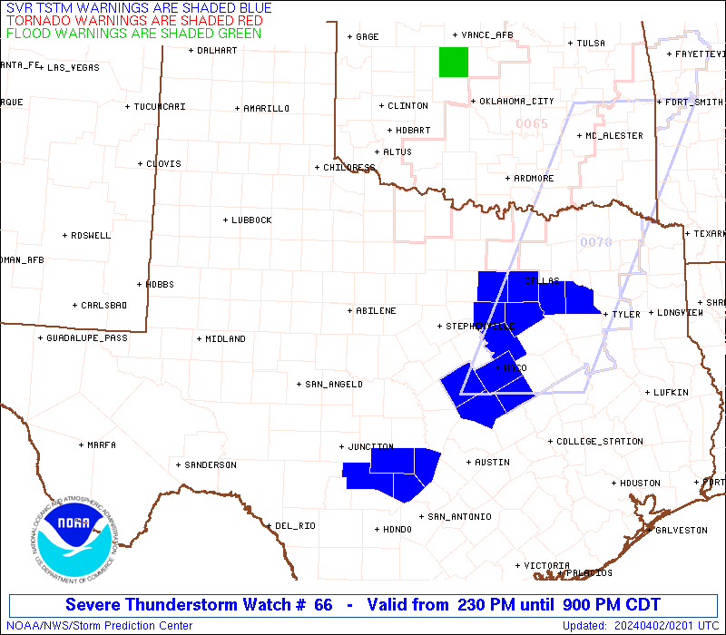
Watch 66 Status Report Messages:
STATUS REPORT #4 ON WW 66
VALID 020045Z - 020140Z
SEVERE WEATHER THREAT CONTINUES RIGHT OF A LINE FROM 50 NNE JCT
TO 55 W GYI.
..WEINMAN..04/02/24
ATTN...WFO...SJT...FWD...
&&
STATUS REPORT FOR WS 66
SEVERE WEATHER THREAT CONTINUES FOR THE FOLLOWING AREAS
TXC035-049-085-093-113-139-143-147-193-217-221-251-333-363-367-
425-439-020140-
TX
. TEXAS COUNTIES INCLUDED ARE
BOSQUE BROWN COLLIN
COMANCHE DALLAS ELLIS
ERATH FANNIN HAMILTON
HILL HOOD JOHNSON
MILLS PALO PINTO PARKER
SOMERVELL TARRANT
$$
THE WATCH STATUS MESSAGE IS FOR GUIDANCE PURPOSES ONLY. PLEASE
REFER TO WATCH COUNTY NOTIFICATION STATEMENTS FOR OFFICIAL
INFORMATION ON COUNTIES...INDEPENDENT CITIES AND MARINE ZONES
CLEARED FROM SEVERE THUNDERSTORM AND TORNADO WATCHES.
$$
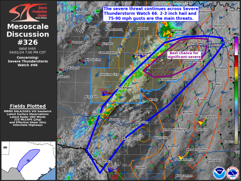
STATUS REPORT #3 ON WW 66
VALID 012350Z - 020040Z
SEVERE WEATHER THREAT CONTINUES RIGHT OF A LINE FROM 25 ESE SJT
TO 25 SE SPS.
FOR ADDITIONAL INFORMATION SEE MESOSCALE DISCUSSION 326
..WEINMAN..04/01/24
ATTN...WFO...SJT...FWD...
&&
STATUS REPORT FOR WS 66
SEVERE WEATHER THREAT CONTINUES FOR THE FOLLOWING AREAS
TXC035-049-083-093-095-113-133-139-143-193-217-221-251-333-363-
367-425-429-439-020040-
TX
. TEXAS COUNTIES INCLUDED ARE
BOSQUE BROWN COLEMAN
COMANCHE CONCHO DALLAS
EASTLAND ELLIS ERATH
HAMILTON HILL HOOD
JOHNSON MILLS PALO PINTO
PARKER SOMERVELL STEPHENS
TARRANT
$$
THE WATCH STATUS MESSAGE IS FOR GUIDANCE PURPOSES ONLY. PLEASE
REFER TO WATCH COUNTY NOTIFICATION STATEMENTS FOR OFFICIAL
INFORMATION ON COUNTIES...INDEPENDENT CITIES AND MARINE ZONES
CLEARED FROM SEVERE THUNDERSTORM AND TORNADO WATCHES.
$$
STATUS REPORT #2 ON WW 66
VALID 012245Z - 012340Z
THE SEVERE WEATHER THREAT CONTINUES ACROSS THE ENTIRE WATCH AREA.
FOR ADDITIONAL INFORMATION SEE MESOSCALE DISCUSSION 326
..WEINMAN..04/01/24
ATTN...WFO...SJT...FWD...
&&
STATUS REPORT FOR WS 66
SEVERE WEATHER THREAT CONTINUES FOR THE FOLLOWING AREAS
TXC049-059-081-083-093-095-133-143-151-207-221-235-253-353-363-
367-399-417-429-431-441-447-451-012340-
TX
. TEXAS COUNTIES INCLUDED ARE
BROWN CALLAHAN COKE
COLEMAN COMANCHE CONCHO
EASTLAND ERATH FISHER
HASKELL HOOD IRION
JONES NOLAN PALO PINTO
PARKER RUNNELS SHACKELFORD
STEPHENS STERLING TAYLOR
THROCKMORTON TOM GREEN
$$
THE WATCH STATUS MESSAGE IS FOR GUIDANCE PURPOSES ONLY. PLEASE
REFER TO WATCH COUNTY NOTIFICATION STATEMENTS FOR OFFICIAL
INFORMATION ON COUNTIES...INDEPENDENT CITIES AND MARINE ZONES
CLEARED FROM SEVERE THUNDERSTORM AND TORNADO WATCHES.
$$
STATUS REPORT #1 ON WW 66
VALID 012155Z - 012240Z
THE SEVERE WEATHER THREAT CONTINUES ACROSS THE ENTIRE WATCH AREA.
..WEINMAN..04/01/24
ATTN...WFO...SJT...FWD...
&&
STATUS REPORT FOR WS 66
SEVERE WEATHER THREAT CONTINUES FOR THE FOLLOWING AREAS
TXC049-059-081-083-093-095-133-143-151-207-221-235-253-353-363-
367-399-417-429-431-441-447-451-012240-
TX
. TEXAS COUNTIES INCLUDED ARE
BROWN CALLAHAN COKE
COLEMAN COMANCHE CONCHO
EASTLAND ERATH FISHER
HASKELL HOOD IRION
JONES NOLAN PALO PINTO
PARKER RUNNELS SHACKELFORD
STEPHENS STERLING TAYLOR
THROCKMORTON TOM GREEN
$$
THE WATCH STATUS MESSAGE IS FOR GUIDANCE PURPOSES ONLY. PLEASE
REFER TO WATCH COUNTY NOTIFICATION STATEMENTS FOR OFFICIAL
INFORMATION ON COUNTIES...INDEPENDENT CITIES AND MARINE ZONES
CLEARED FROM SEVERE THUNDERSTORM AND TORNADO WATCHES.
$$
Note:
Click for Complete Product Text.
Tornadoes
Probability of 2 or more tornadoes
|
Low (10%)
|
Probability of 1 or more strong (EF2-EF5) tornadoes
|
Low (<2%)
|
Wind
Probability of 10 or more severe wind events
|
Low (20%)
|
Probability of 1 or more wind events > 65 knots
|
Low (10%)
|
Hail
Probability of 10 or more severe hail events
|
Mod (40%)
|
Probability of 1 or more hailstones > 2 inches
|
Mod (40%)
|
Combined Severe Hail/Wind
Probability of 6 or more combined severe hail/wind events
|
Mod (60%)
|
For each watch, probabilities for particular events inside the watch
(listed above in each table) are determined by the issuing forecaster.
The "Low" category contains probability values ranging from less than 2%
to 20% (EF2-EF5 tornadoes), less than 5% to 20% (all other probabilities),
"Moderate" from 30% to 60%, and "High" from 70% to greater than 95%.
High values are bolded and lighter in color to provide awareness of
an increased threat for a particular event.


 @NWSSPC