 Note:
The expiration time in the watch graphic is amended if the watch is
replaced, cancelled or extended.
Note:
Note:
The expiration time in the watch graphic is amended if the watch is
replaced, cancelled or extended.
Note: Click for
Watch Status Reports.
SEL4
URGENT - IMMEDIATE BROADCAST REQUESTED
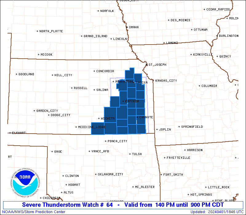
Severe Thunderstorm Watch Number 64
NWS Storm Prediction Center Norman OK
140 PM CDT Mon Apr 1 2024
The NWS Storm Prediction Center has issued a
* Severe Thunderstorm Watch for portions of
Eastern Kansas
* Effective this Monday afternoon and evening from 140 PM until
900 PM CDT.
* Primary threats include...
Scattered large hail and isolated very large hail events to 2.5
inches in diameter likely
Scattered damaging wind gusts to 70 mph possible
A tornado or two possible
SUMMARY...Scattered severe thunderstorm development is expected this
afternoon across southeast and eastern Kansas, with the potential
for supercells with isolated very large hail (up to 2.5 inches in
diameter) and damaging gusts of 60-70 mph. The tornado threat will
remain somewhat limited, though an isolated tornado cannot be ruled
out, especially later this evening.
The severe thunderstorm watch area is approximately along and 50
statute miles east and west of a line from 50 miles south southwest
of Chanute KS to 20 miles northwest of Topeka KS. For a complete
depiction of the watch see the associated watch outline update
(WOUS64 KWNS WOU4).
PRECAUTIONARY/PREPAREDNESS ACTIONS...
REMEMBER...A Severe Thunderstorm Watch means conditions are
favorable for severe thunderstorms in and close to the watch area.
Persons in these areas should be on the lookout for threatening
weather conditions and listen for later statements and possible
warnings. Severe thunderstorms can and occasionally do produce
tornadoes.
&&
AVIATION...A few severe thunderstorms with hail surface and aloft to
2.5 inches. Extreme turbulence and surface wind gusts to 60 knots. A
few cumulonimbi with maximum tops to 500. Mean storm motion vector
24035.
...Thompson

   SEL4

   URGENT - IMMEDIATE BROADCAST REQUESTED
   Severe Thunderstorm Watch Number 64
   NWS Storm Prediction Center Norman OK
   140 PM CDT Mon Apr 1 2024

   The NWS Storm Prediction Center has issued a

   * Severe Thunderstorm Watch for portions of
     Eastern Kansas

   * Effective this Monday afternoon and evening from 140 PM until
     900 PM CDT.

   * Primary threats include...
     Scattered large hail and isolated very large hail events to 2.5
       inches in diameter likely
     Scattered damaging wind gusts to 70 mph possible
     A tornado or two possible

   SUMMARY...Scattered severe thunderstorm development is expected this
   afternoon across southeast and eastern Kansas, with the potential
   for supercells with isolated very large hail (up to 2.5 inches in
   diameter) and damaging gusts of 60-70 mph.  The tornado threat will
   remain somewhat limited, though an isolated tornado cannot be ruled
   out, especially later this evening.

   The severe thunderstorm watch area is approximately along and 50
   statute miles east and west of a line from 50 miles south southwest
   of Chanute KS to 20 miles northwest of Topeka KS. For a complete
   depiction of the watch see the associated watch outline update
   (WOUS64 KWNS WOU4).

   PRECAUTIONARY/PREPAREDNESS ACTIONS...

   REMEMBER...A Severe Thunderstorm Watch means conditions are
   favorable for severe thunderstorms in and close to the watch area.
   Persons in these areas should be on the lookout for threatening
   weather conditions and listen for later statements and possible
   warnings. Severe thunderstorms can and occasionally do produce
   tornadoes.

   &&

   AVIATION...A few severe thunderstorms with hail surface and aloft to
   2.5 inches. Extreme turbulence and surface wind gusts to 60 knots. A
   few cumulonimbi with maximum tops to 500. Mean storm motion vector
   24035.

   ...Thompson
 Note:
The Aviation Watch (SAW) product is an approximation to the watch area.
The actual watch is depicted by the shaded areas.
Note:
The Aviation Watch (SAW) product is an approximation to the watch area.
The actual watch is depicted by the shaded areas.
   SAW4
   WW 64 SEVERE TSTM KS 011840Z - 020200Z
   AXIS..50 STATUTE MILES EAST AND WEST OF LINE..
   50SSW CNU/CHANUTE KS/ - 20NW TOP/TOPEKA KS/
   ..AVIATION COORDS.. 45NM E/W /31WSW OSW - 53W MCI/
   HAIL SURFACE AND ALOFT..2.5 INCHES. WIND GUSTS..60 KNOTS.
   MAX TOPS TO 500. MEAN STORM MOTION VECTOR 24035.

   LAT...LON 37009673 39279682 39279495 37009492

   THIS IS AN APPROXIMATION TO THE WATCH AREA.  FOR A
   COMPLETE DEPICTION OF THE WATCH SEE WOUS64 KWNS
   FOR WOU4.
Watch 64 Status Report Messages:
STATUS REPORT #5 ON WW 64

VALID 020040Z - 020140Z

SEVERE WEATHER THREAT CONTINUES RIGHT OF A LINE FROM 20 NE PNC TO
25 SSE EMP TO 40 S OJC.

..WEINMAN..04/02/24

ATTN...WFO...ICT...TOP...

&&

STATUS REPORT FOR WS 64

SEVERE WEATHER THREAT CONTINUES FOR THE FOLLOWING AREAS

KSC001-019-099-125-133-205-207-020140-

KS
.    KANSAS COUNTIES INCLUDED ARE

ALLEN		     CHAUTAUQUA 	 LABETTE
MONTGOMERY	     NEOSHO		 WILSON
WOODSON
$$


THE WATCH STATUS MESSAGE IS FOR GUIDANCE PURPOSES ONLY.  PLEASE
REFER TO WATCH COUNTY NOTIFICATION STATEMENTS FOR OFFICIAL
INFORMATION ON COUNTIES...INDEPENDENT CITIES AND MARINE ZONES
CLEARED FROM SEVERE THUNDERSTORM AND TORNADO WATCHES.
$$

STATUS REPORT #4 ON WW 64

VALID 012335Z - 020040Z

SEVERE WEATHER THREAT CONTINUES RIGHT OF A LINE FROM 20 NE PNC TO
25 SSE EMP TO 40 S OJC.

FOR ADDITIONAL INFORMATION SEE MESOSCALE DISCUSSION 327

..WEINMAN..04/01/24

ATTN...WFO...ICT...TOP...

&&

STATUS REPORT FOR WS 64

SEVERE WEATHER THREAT CONTINUES FOR THE FOLLOWING AREAS

KSC001-019-099-125-133-205-207-020040-

KS
.    KANSAS COUNTIES INCLUDED ARE

ALLEN		     CHAUTAUQUA 	 LABETTE
MONTGOMERY	     NEOSHO		 WILSON
WOODSON
$$


THE WATCH STATUS MESSAGE IS FOR GUIDANCE PURPOSES ONLY.  PLEASE
REFER TO WATCH COUNTY NOTIFICATION STATEMENTS FOR OFFICIAL
INFORMATION ON COUNTIES...INDEPENDENT CITIES AND MARINE ZONES
CLEARED FROM SEVERE THUNDERSTORM AND TORNADO WATCHES.
$$

STATUS REPORT #3 ON WW 64

VALID 012240Z - 012340Z

SEVERE WEATHER THREAT CONTINUES RIGHT OF A LINE FROM 10 S PNC TO
10 WNW FLV.

FOR ADDITIONAL INFORMATION SEE MESOSCALE DISCUSSION 327

..WEINMAN..04/01/24

ATTN...WFO...ICT...TOP...

&&

STATUS REPORT FOR WS 64

SEVERE WEATHER THREAT CONTINUES FOR THE FOLLOWING AREAS

KSC001-003-019-031-035-045-049-059-073-099-125-133-205-207-
012340-

KS
.    KANSAS COUNTIES INCLUDED ARE

ALLEN		     ANDERSON		 CHAUTAUQUA
COFFEY		     COWLEY		 DOUGLAS
ELK		     FRANKLIN		 GREENWOOD
LABETTE 	     MONTGOMERY 	 NEOSHO
WILSON		     WOODSON
$$


THE WATCH STATUS MESSAGE IS FOR GUIDANCE PURPOSES ONLY.  PLEASE
REFER TO WATCH COUNTY NOTIFICATION STATEMENTS FOR OFFICIAL
INFORMATION ON COUNTIES...INDEPENDENT CITIES AND MARINE ZONES
CLEARED FROM SEVERE THUNDERSTORM AND TORNADO WATCHES.
$$

STATUS REPORT #2 ON WW 64

VALID 012150Z - 012240Z

SEVERE WEATHER THREAT CONTINUES RIGHT OF A LINE FROM 40 WSW EMP
TO 20 N TOP.

..WEINMAN..04/01/24

ATTN...WFO...ICT...TOP...

&&

STATUS REPORT FOR WS 64

SEVERE WEATHER THREAT CONTINUES FOR THE FOLLOWING AREAS

KSC001-003-015-017-019-031-035-045-049-059-073-087-099-111-125-
133-139-177-191-205-207-012240-

KS
.    KANSAS COUNTIES INCLUDED ARE

ALLEN		     ANDERSON		 BUTLER
CHASE		     CHAUTAUQUA 	 COFFEY
COWLEY		     DOUGLAS		 ELK
FRANKLIN	     GREENWOOD		 JEFFERSON
LABETTE 	     LYON		 MONTGOMERY
NEOSHO		     OSAGE		 SHAWNEE
SUMNER		     WILSON		 WOODSON
$$


THE WATCH STATUS MESSAGE IS FOR GUIDANCE PURPOSES ONLY.  PLEASE
REFER TO WATCH COUNTY NOTIFICATION STATEMENTS FOR OFFICIAL
INFORMATION ON COUNTIES...INDEPENDENT CITIES AND MARINE ZONES
CLEARED FROM SEVERE THUNDERSTORM AND TORNADO WATCHES.
$$

STATUS REPORT #1 ON WW 64

VALID 012150Z - 012240Z

SEVERE WEATHER THREAT CONTINUES RIGHT OF A LINE FROM 40 WSW EMP
TO 20 N TOP.

..WEINMAN..04/01/24

ATTN...WFO...ICT...TOP...

&&

STATUS REPORT FOR WS 64

SEVERE WEATHER THREAT CONTINUES FOR THE FOLLOWING AREAS

KSC001-003-015-017-019-031-035-045-049-059-073-087-099-111-125-
133-139-177-191-205-207-012240-

KS
.    KANSAS COUNTIES INCLUDED ARE

ALLEN		     ANDERSON		 BUTLER
CHASE		     CHAUTAUQUA 	 COFFEY
COWLEY		     DOUGLAS		 ELK
FRANKLIN	     GREENWOOD		 JEFFERSON
LABETTE 	     LYON		 MONTGOMERY
NEOSHO		     OSAGE		 SHAWNEE
SUMNER		     WILSON		 WOODSON
$$


THE WATCH STATUS MESSAGE IS FOR GUIDANCE PURPOSES ONLY.  PLEASE
REFER TO WATCH COUNTY NOTIFICATION STATEMENTS FOR OFFICIAL
INFORMATION ON COUNTIES...INDEPENDENT CITIES AND MARINE ZONES
CLEARED FROM SEVERE THUNDERSTORM AND TORNADO WATCHES.
$$
Note:
Click for Complete Product Text.
Tornadoes
Probability of 2 or more tornadoes
|
Low (20%)
|
Probability of 1 or more strong (EF2-EF5) tornadoes
|
Low (10%)
|
Wind
Probability of 10 or more severe wind events
|
Mod (40%)
|
Probability of 1 or more wind events > 65 knots
|
Low (20%)
|
Hail
Probability of 10 or more severe hail events
|
Mod (60%)
|
Probability of 1 or more hailstones > 2 inches
|
Mod (60%)
|
Combined Severe Hail/Wind
Probability of 6 or more combined severe hail/wind events
|
High (90%)
|
For each watch, probabilities for particular events inside the watch
(listed above in each table) are determined by the issuing forecaster.
The "Low" category contains probability values ranging from less than 2%
to 20% (EF2-EF5 tornadoes), less than 5% to 20% (all other probabilities),
"Moderate" from 30% to 60%, and "High" from 70% to greater than 95%.
High values are bolded and lighter in color to provide awareness of
an increased threat for a particular event.


 @NWSSPC