 Note:
The expiration time in the watch graphic is amended if the watch is
replaced, cancelled or extended.
Note:
Note:
The expiration time in the watch graphic is amended if the watch is
replaced, cancelled or extended.
Note: Click for
Watch Status Reports.
SEL0
URGENT - IMMEDIATE BROADCAST REQUESTED
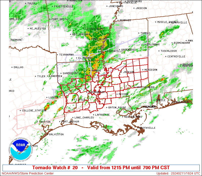
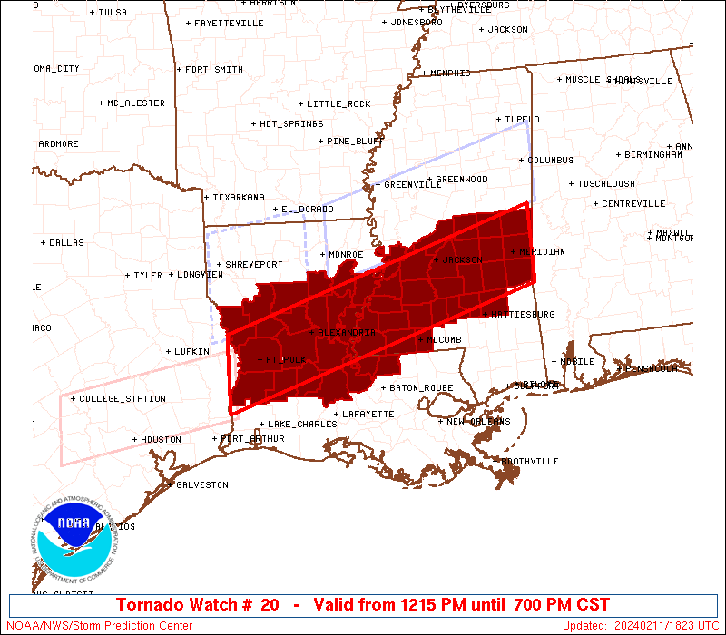
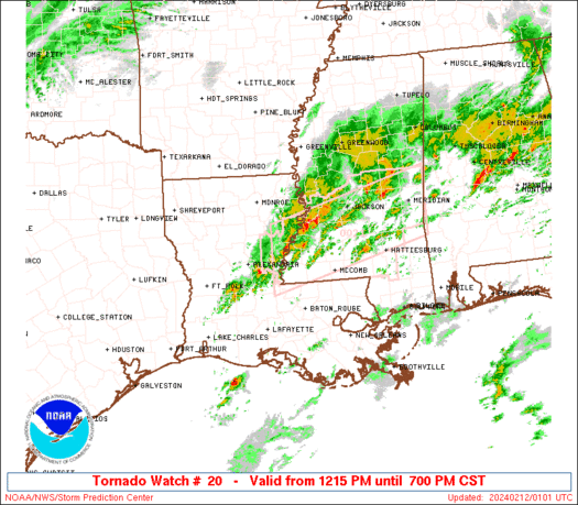
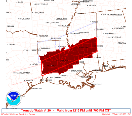
Tornado Watch Number 20
NWS Storm Prediction Center Norman OK
1215 PM CST Sun Feb 11 2024
The NWS Storm Prediction Center has issued a
* Tornado Watch for portions of
Central Louisiana
Central Mississippi
* Effective this Sunday afternoon and evening from 1215 PM until
700 PM CST.
* Primary threats include...
A few tornadoes likely with a couple intense tornadoes possible
Widespread large hail and scattered very large hail events to
2.5 inches in diameter likely
Scattered damaging wind gusts to 70 mph likely
SUMMARY...Scattered supercell development is expected this afternoon
along and just south of a warm front from central Louisiana into
central Mississippi, and storms will spread eastward through this
evening. The most intense supercells along the front will be
capable of producing a couple of strong tornadoes (roughly EF2
damage potential) and large hail of 1.75-2.5 inches in diameter.
Occasional damaging gusts of 60-70 mph will also be possible.
The tornado watch area is approximately along and 40 statute miles
north and south of a line from 35 miles west southwest of Fort Polk
LA to 20 miles east northeast of Meridian MS. For a complete
depiction of the watch see the associated watch outline update
(WOUS64 KWNS WOU0).
PRECAUTIONARY/PREPAREDNESS ACTIONS...
REMEMBER...A Tornado Watch means conditions are favorable for
tornadoes and severe thunderstorms in and close to the watch
area. Persons in these areas should be on the lookout for
threatening weather conditions and listen for later statements
and possible warnings.
&&
OTHER WATCH INFORMATION...CONTINUE...WW 17...WW 18...WW 19...
AVIATION...Tornadoes and a few severe thunderstorms with hail
surface and aloft to 2.5 inches. Extreme turbulence and surface wind
gusts to 60 knots. A few cumulonimbi with maximum tops to 500. Mean
storm motion vector 26035.
...Thompson

   SEL0

   URGENT - IMMEDIATE BROADCAST REQUESTED
   Tornado Watch Number 20
   NWS Storm Prediction Center Norman OK
   1215 PM CST Sun Feb 11 2024

   The NWS Storm Prediction Center has issued a

   * Tornado Watch for portions of
     Central Louisiana
     Central Mississippi

   * Effective this Sunday afternoon and evening from 1215 PM until
     700 PM CST.

   * Primary threats include...
     A few tornadoes likely with a couple intense tornadoes possible
     Widespread large hail and scattered very large hail events to
       2.5 inches in diameter likely
     Scattered damaging wind gusts to 70 mph likely

   SUMMARY...Scattered supercell development is expected this afternoon
   along and just south of a warm front from central Louisiana into
   central Mississippi, and storms will spread eastward through this
   evening.  The most intense supercells along the front will be
   capable of producing a couple of strong tornadoes (roughly EF2
   damage potential) and large hail of 1.75-2.5 inches in diameter.
   Occasional damaging gusts of 60-70 mph will also be possible.

   The tornado watch area is approximately along and 40 statute miles
   north and south of a line from 35 miles west southwest of Fort Polk
   LA to 20 miles east northeast of Meridian MS. For a complete
   depiction of the watch see the associated watch outline update
   (WOUS64 KWNS WOU0).

   PRECAUTIONARY/PREPAREDNESS ACTIONS...

   REMEMBER...A Tornado Watch means conditions are favorable for
   tornadoes and severe thunderstorms in and close to the watch
   area. Persons in these areas should be on the lookout for
   threatening weather conditions and listen for later statements
   and possible warnings.

   &&

   OTHER WATCH INFORMATION...CONTINUE...WW 17...WW 18...WW 19...

   AVIATION...Tornadoes and a few severe thunderstorms with hail
   surface and aloft to 2.5 inches. Extreme turbulence and surface wind
   gusts to 60 knots. A few cumulonimbi with maximum tops to 500. Mean
   storm motion vector 26035.

   ...Thompson
 Note:
The Aviation Watch (SAW) product is an approximation to the watch area.
The actual watch is depicted by the shaded areas.
Note:
The Aviation Watch (SAW) product is an approximation to the watch area.
The actual watch is depicted by the shaded areas.
   SAW0
   WW 20 TORNADO LA MS 111815Z - 120100Z
   AXIS..40 STATUTE MILES NORTH AND SOUTH OF LINE..
   35WSW POE/FORT POLK LA/ - 20ENE MEI/MERIDIAN MS/
   ..AVIATION COORDS.. 35NM N/S /53NW LCH - 19E MEI/
   HAIL SURFACE AND ALOFT..2.5 INCHES. WIND GUSTS..60 KNOTS.
   MAX TOPS TO 500. MEAN STORM MOTION VECTOR 26035.

   LAT...LON 31439373 33028843 31868843 30289373

   THIS IS AN APPROXIMATION TO THE WATCH AREA.  FOR A
   COMPLETE DEPICTION OF THE WATCH SEE WOUS64 KWNS
   FOR WOU0.
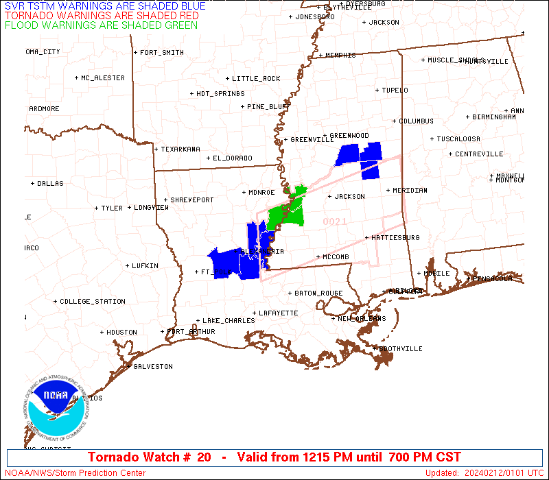
Watch 20 Status Report Messages:
STATUS REPORT #4 ON WW 20

VALID 112230Z - 112340Z

SEVERE WEATHER THREAT CONTINUES RIGHT OF A LINE FROM 40 W POE TO
25 NW ESF TO 20 E MLU.

..MOORE..02/11/24

ATTN...WFO...LCH...SHV...JAN...LIX...

&&

STATUS REPORT FOR WT 20

SEVERE WEATHER THREAT CONTINUES FOR THE FOLLOWING AREAS

LAC003-009-011-025-029-037-039-041-059-077-079-097-107-115-125-
112340-

LA
.    LOUISIANA PARISHES INCLUDED ARE

ALLEN		     AVOYELLES		 BEAUREGARD
CATAHOULA	     CONCORDIA		 EAST FELICIANA
EVANGELINE	     FRANKLIN		 LA SALLE
POINTE COUPEE	     RAPIDES		 ST. LANDRY
TENSAS		     VERNON		 WEST FELICIANA
$$


MSC001-005-021-023-029-031-035-037-049-061-063-065-067-069-073-
075-077-079-085-089-091-099-101-113-121-123-127-129-149-157-
112340-

MS
.    MISSISSIPPI COUNTIES INCLUDED ARE

ADAMS		     AMITE		 CLAIBORNE
CLARKE		     COPIAH		 COVINGTON
FORREST 	     FRANKLIN		 HINDS
JASPER		     JEFFERSON		 JEFFERSON DAVIS
JONES		     KEMPER		 LAMAR
LAUDERDALE	     LAWRENCE		 LEAKE
LINCOLN 	     MADISON		 MARION
NESHOBA 	     NEWTON		 PIKE
RANKIN		     SCOTT		 SIMPSON
SMITH		     WARREN		 WILKINSON
$$


THE WATCH STATUS MESSAGE IS FOR GUIDANCE PURPOSES ONLY.  PLEASE
REFER TO WATCH COUNTY NOTIFICATION STATEMENTS FOR OFFICIAL
INFORMATION ON COUNTIES...INDEPENDENT CITIES AND MARINE ZONES
CLEARED FROM SEVERE THUNDERSTORM AND TORNADO WATCHES.
$$

STATUS REPORT #3 ON WW 20

VALID 112145Z - 112240Z

SEVERE WEATHER THREAT CONTINUES RIGHT OF A LINE FROM 40 W POE TO
15 ESE IER TO 20 NNE MLU.

FOR ADDITIONAL INFORMATION SEE MESOSCALE DISCUSSION 130

..MOORE..02/11/24

ATTN...WFO...LCH...SHV...JAN...LIX...

&&

STATUS REPORT FOR WT 20

SEVERE WEATHER THREAT CONTINUES FOR THE FOLLOWING AREAS

LAC003-009-011-021-025-029-037-039-041-059-069-077-079-097-107-
115-125-112240-

LA
.    LOUISIANA PARISHES INCLUDED ARE

ALLEN		     AVOYELLES		 BEAUREGARD
CALDWELL	     CATAHOULA		 CONCORDIA
EAST FELICIANA	     EVANGELINE 	 FRANKLIN
LA SALLE	     NATCHITOCHES	 POINTE COUPEE
RAPIDES 	     ST. LANDRY 	 TENSAS
VERNON		     WEST FELICIANA
$$


MSC001-005-021-023-029-031-037-049-061-063-065-067-069-075-077-
079-085-089-099-101-113-121-123-127-129-149-157-112240-

MS
.    MISSISSIPPI COUNTIES INCLUDED ARE

ADAMS		     AMITE		 CLAIBORNE
CLARKE		     COPIAH		 COVINGTON
FRANKLIN	     HINDS		 JASPER
JEFFERSON	     JEFFERSON DAVIS	 JONES
KEMPER		     LAUDERDALE 	 LAWRENCE
LEAKE		     LINCOLN		 MADISON
NESHOBA 	     NEWTON		 PIKE
RANKIN		     SCOTT		 SIMPSON
SMITH		     WARREN		 WILKINSON
$$


THE WATCH STATUS MESSAGE IS FOR GUIDANCE PURPOSES ONLY.  PLEASE
REFER TO WATCH COUNTY NOTIFICATION STATEMENTS FOR OFFICIAL
INFORMATION ON COUNTIES...INDEPENDENT CITIES AND MARINE ZONES
CLEARED FROM SEVERE THUNDERSTORM AND TORNADO WATCHES.
$$

STATUS REPORT #2 ON WW 20

VALID 112040Z - 112140Z

SEVERE WEATHER THREAT CONTINUES RIGHT OF A LINE FROM 40 W POE TO
15 W MLU.

FOR ADDITIONAL INFORMATION SEE MESOSCALE DISCUSSION 130

..MOORE..02/11/24

ATTN...WFO...LCH...SHV...JAN...LIX...

&&

STATUS REPORT FOR WT 20

SEVERE WEATHER THREAT CONTINUES FOR THE FOLLOWING AREAS

LAC003-009-011-021-025-029-037-039-041-043-059-069-077-079-097-
107-115-125-127-112140-

LA
.    LOUISIANA PARISHES INCLUDED ARE

ALLEN		     AVOYELLES		 BEAUREGARD
CALDWELL	     CATAHOULA		 CONCORDIA
EAST FELICIANA	     EVANGELINE 	 FRANKLIN
GRANT		     LA SALLE		 NATCHITOCHES
POINTE COUPEE	     RAPIDES		 ST. LANDRY
TENSAS		     VERNON		 WEST FELICIANA
WINN
$$


MSC001-005-021-023-029-031-037-049-061-063-065-067-069-075-077-
079-085-089-099-101-113-121-123-127-129-149-157-112140-

MS
.    MISSISSIPPI COUNTIES INCLUDED ARE

ADAMS		     AMITE		 CLAIBORNE
CLARKE		     COPIAH		 COVINGTON
FRANKLIN	     HINDS		 JASPER
JEFFERSON	     JEFFERSON DAVIS	 JONES
KEMPER		     LAUDERDALE 	 LAWRENCE
LEAKE		     LINCOLN		 MADISON
NESHOBA 	     NEWTON		 PIKE
RANKIN		     SCOTT		 SIMPSON
SMITH		     WARREN		 WILKINSON
$$


THE WATCH STATUS MESSAGE IS FOR GUIDANCE PURPOSES ONLY.  PLEASE
REFER TO WATCH COUNTY NOTIFICATION STATEMENTS FOR OFFICIAL
INFORMATION ON COUNTIES...INDEPENDENT CITIES AND MARINE ZONES
CLEARED FROM SEVERE THUNDERSTORM AND TORNADO WATCHES.
$$

STATUS REPORT #1 ON WW 20

VALID 111940Z - 112040Z

THE SEVERE WEATHER THREAT CONTINUES ACROSS THE ENTIRE WATCH AREA.

..MOORE..02/11/24

ATTN...WFO...LCH...SHV...JAN...LIX...

&&

STATUS REPORT FOR WT 20

SEVERE WEATHER THREAT CONTINUES FOR THE FOLLOWING AREAS

LAC003-009-011-021-025-029-037-039-041-043-059-069-077-079-085-
097-107-115-125-127-112040-

LA
.    LOUISIANA PARISHES INCLUDED ARE

ALLEN		     AVOYELLES		 BEAUREGARD
CALDWELL	     CATAHOULA		 CONCORDIA
EAST FELICIANA	     EVANGELINE 	 FRANKLIN
GRANT		     LA SALLE		 NATCHITOCHES
POINTE COUPEE	     RAPIDES		 SABINE
ST. LANDRY	     TENSAS		 VERNON
WEST FELICIANA	     WINN
$$


MSC001-005-021-023-029-031-037-049-061-063-065-067-069-075-077-
079-085-089-099-101-113-121-123-127-129-149-157-112040-

MS
.    MISSISSIPPI COUNTIES INCLUDED ARE

ADAMS		     AMITE		 CLAIBORNE
CLARKE		     COPIAH		 COVINGTON
FRANKLIN	     HINDS		 JASPER
JEFFERSON	     JEFFERSON DAVIS	 JONES
KEMPER		     LAUDERDALE 	 LAWRENCE
LEAKE		     LINCOLN		 MADISON
NESHOBA 	     NEWTON		 PIKE
RANKIN		     SCOTT		 SIMPSON
SMITH		     WARREN		 WILKINSON
$$


THE WATCH STATUS MESSAGE IS FOR GUIDANCE PURPOSES ONLY.  PLEASE
REFER TO WATCH COUNTY NOTIFICATION STATEMENTS FOR OFFICIAL
INFORMATION ON COUNTIES...INDEPENDENT CITIES AND MARINE ZONES
CLEARED FROM SEVERE THUNDERSTORM AND TORNADO WATCHES.
$$
Note:
Click for Complete Product Text.
Tornadoes
Probability of 2 or more tornadoes
|
High (70%)
|
Probability of 1 or more strong (EF2-EF5) tornadoes
|
Mod (40%)
|
Wind
Probability of 10 or more severe wind events
|
Mod (60%)
|
Probability of 1 or more wind events > 65 knots
|
Low (20%)
|
Hail
Probability of 10 or more severe hail events
|
High (80%)
|
Probability of 1 or more hailstones > 2 inches
|
High (80%)
|
Combined Severe Hail/Wind
Probability of 6 or more combined severe hail/wind events
|
High (>95%)
|
For each watch, probabilities for particular events inside the watch
(listed above in each table) are determined by the issuing forecaster.
The "Low" category contains probability values ranging from less than 2%
to 20% (EF2-EF5 tornadoes), less than 5% to 20% (all other probabilities),
"Moderate" from 30% to 60%, and "High" from 70% to greater than 95%.
High values are bolded and lighter in color to provide awareness of
an increased threat for a particular event.


 @NWSSPC