 Note:
The expiration time in the watch graphic is amended if the watch is
replaced, cancelled or extended.
Note:
Note:
The expiration time in the watch graphic is amended if the watch is
replaced, cancelled or extended.
Note: Click for
Watch Status Reports.
SEL9
URGENT - IMMEDIATE BROADCAST REQUESTED
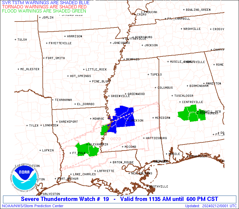
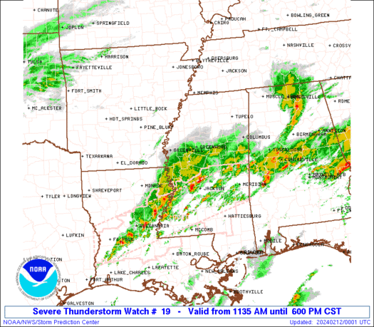
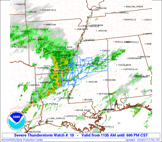
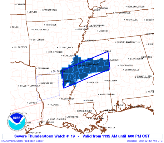
Severe Thunderstorm Watch Number 19
NWS Storm Prediction Center Norman OK
1135 AM CST Sun Feb 11 2024
The NWS Storm Prediction Center has issued a
* Severe Thunderstorm Watch for portions of
Extreme southeast Arkansas
Northeast Louisiana
Central Mississippi
* Effective this Sunday morning and evening from 1135 AM until
600 PM CST.
* Primary threats include...
Scattered large hail and isolated very large hail events to 2
inches in diameter possible
Isolated damaging wind gusts to 70 mph possible
SUMMARY...Elevated supercells will spread eastward from southeast
Arkansas and northeast Louisiana into Mississippi through the
afternoon. Large hail (1-2" diameter) will be the main threat,
though isolated damaging winds of 60-70 mph will also be possible.
The severe thunderstorm watch area is approximately along and 40
statute miles north and south of a line from 80 miles southwest of
Greenville MS to 10 miles east of Columbus MS. For a complete
depiction of the watch see the associated watch outline update
(WOUS64 KWNS WOU9).
PRECAUTIONARY/PREPAREDNESS ACTIONS...
REMEMBER...A Severe Thunderstorm Watch means conditions are
favorable for severe thunderstorms in and close to the watch area.
Persons in these areas should be on the lookout for threatening
weather conditions and listen for later statements and possible
warnings. Severe thunderstorms can and occasionally do produce
tornadoes.
&&
OTHER WATCH INFORMATION...CONTINUE...WW 17...WW 18...
AVIATION...A few severe thunderstorms with hail surface and aloft to
2 inches. Extreme turbulence and surface wind gusts to 60 knots. A
few cumulonimbi with maximum tops to 450. Mean storm motion vector
26035.
...Thompson
   SEL9

   URGENT - IMMEDIATE BROADCAST REQUESTED
   Severe Thunderstorm Watch Number 19
   NWS Storm Prediction Center Norman OK
   1135 AM CST Sun Feb 11 2024

   The NWS Storm Prediction Center has issued a

   * Severe Thunderstorm Watch for portions of
     Extreme southeast Arkansas
     Northeast Louisiana
     Central Mississippi

   * Effective this Sunday morning and evening from 1135 AM until
     600 PM CST.

   * Primary threats include...
     Scattered large hail and isolated very large hail events to 2
       inches in diameter possible
     Isolated damaging wind gusts to 70 mph possible

   SUMMARY...Elevated supercells will spread eastward from southeast
   Arkansas and northeast Louisiana into Mississippi through the
   afternoon.  Large hail (1-2" diameter) will be the main threat,
   though isolated damaging winds of 60-70 mph will also be possible.

   The severe thunderstorm watch area is approximately along and 40
   statute miles north and south of a line from 80 miles southwest of
   Greenville MS to 10 miles east of Columbus MS. For a complete
   depiction of the watch see the associated watch outline update
   (WOUS64 KWNS WOU9).

   PRECAUTIONARY/PREPAREDNESS ACTIONS...

   REMEMBER...A Severe Thunderstorm Watch means conditions are
   favorable for severe thunderstorms in and close to the watch area.
   Persons in these areas should be on the lookout for threatening
   weather conditions and listen for later statements and possible
   warnings. Severe thunderstorms can and occasionally do produce
   tornadoes.

   &&

   OTHER WATCH INFORMATION...CONTINUE...WW 17...WW 18...

   AVIATION...A few severe thunderstorms with hail surface and aloft to
   2 inches. Extreme turbulence and surface wind gusts to 60 knots. A
   few cumulonimbi with maximum tops to 450. Mean storm motion vector
   26035.

   ...Thompson
 Note:
The Aviation Watch (SAW) product is an approximation to the watch area.
The actual watch is depicted by the shaded areas.
Note:
The Aviation Watch (SAW) product is an approximation to the watch area.
The actual watch is depicted by the shaded areas.
   SAW9
   WW 19 SEVERE TSTM AR LA MS 111735Z - 120000Z
   AXIS..40 STATUTE MILES NORTH AND SOUTH OF LINE..
   80SW GLH/GREENVILLE MS/ - 10E CBM/COLUMBUS MS/
   ..AVIATION COORDS.. 35NM N/S /9NNE MLU - 15NE IGB/
   HAIL SURFACE AND ALOFT..2 INCHES. WIND GUSTS..60 KNOTS.
   MAX TOPS TO 450. MEAN STORM MOTION VECTOR 26035.

   LAT...LON 33239195 34218828 33058828 32079195

   THIS IS AN APPROXIMATION TO THE WATCH AREA.  FOR A
   COMPLETE DEPICTION OF THE WATCH SEE WOUS64 KWNS
   FOR WOU9.
Watch 19 Status Report Messages:
STATUS REPORT #6 ON WW 19

VALID 112230Z - 112340Z

SEVERE WEATHER THREAT CONTINUES RIGHT OF A LINE FROM 10 W MLU TO
55 SW CBM TO 25 NW TCL.

..MOORE..02/11/24

ATTN...WFO...JAN...

&&

STATUS REPORT FOR WS 19

SEVERE WEATHER THREAT CONTINUES FOR THE FOLLOWING AREAS

LAC065-083-112340-

LA
.    LOUISIANA PARISHES INCLUDED ARE

MADISON 	     RICHLAND
$$


MSC103-159-112340-

MS
.    MISSISSIPPI COUNTIES INCLUDED ARE

NOXUBEE 	     WINSTON
$$


THE WATCH STATUS MESSAGE IS FOR GUIDANCE PURPOSES ONLY.  PLEASE
REFER TO WATCH COUNTY NOTIFICATION STATEMENTS FOR OFFICIAL
INFORMATION ON COUNTIES...INDEPENDENT CITIES AND MARINE ZONES
CLEARED FROM SEVERE THUNDERSTORM AND TORNADO WATCHES.
$$

STATUS REPORT #5 ON WW 19

VALID 112140Z - 112240Z

SEVERE WEATHER THREAT CONTINUES RIGHT OF A LINE FROM 25 SW MLU TO
55 ESE GWO TO 20 NE TUP.

..MOORE..02/11/24

ATTN...WFO...JAN...

&&

STATUS REPORT FOR WS 19

SEVERE WEATHER THREAT CONTINUES FOR THE FOLLOWING AREAS

LAC065-083-112240-

LA
.    LOUISIANA PARISHES INCLUDED ARE

MADISON 	     RICHLAND
$$


MSC025-087-103-105-159-112240-

MS
.    MISSISSIPPI COUNTIES INCLUDED ARE

CLAY		     LOWNDES		 NOXUBEE
OKTIBBEHA	     WINSTON
$$


THE WATCH STATUS MESSAGE IS FOR GUIDANCE PURPOSES ONLY.  PLEASE
REFER TO WATCH COUNTY NOTIFICATION STATEMENTS FOR OFFICIAL
INFORMATION ON COUNTIES...INDEPENDENT CITIES AND MARINE ZONES
CLEARED FROM SEVERE THUNDERSTORM AND TORNADO WATCHES.
$$

STATUS REPORT #4 ON WW 19

VALID 112040Z - 112140Z

SEVERE WEATHER THREAT CONTINUES RIGHT OF A LINE FROM 10 W MLU TO
55 SSE GLH TO 20 SE GWO TO 15 S UOX.

FOR ADDITIONAL INFORMATION SEE MESOSCALE DISCUSSION 131

..MOORE..02/11/24

ATTN...WFO...JAN...

&&

STATUS REPORT FOR WS 19

SEVERE WEATHER THREAT CONTINUES FOR THE FOLLOWING AREAS

LAC065-083-112140-

LA
.    LOUISIANA PARISHES INCLUDED ARE

MADISON 	     RICHLAND
$$


MSC007-019-025-051-087-097-103-105-155-159-163-112140-

MS
.    MISSISSIPPI COUNTIES INCLUDED ARE

ATTALA		     CHOCTAW		 CLAY
HOLMES		     LOWNDES		 MONTGOMERY
NOXUBEE 	     OKTIBBEHA		 WEBSTER
WINSTON 	     YAZOO
$$


THE WATCH STATUS MESSAGE IS FOR GUIDANCE PURPOSES ONLY.  PLEASE
REFER TO WATCH COUNTY NOTIFICATION STATEMENTS FOR OFFICIAL
INFORMATION ON COUNTIES...INDEPENDENT CITIES AND MARINE ZONES
CLEARED FROM SEVERE THUNDERSTORM AND TORNADO WATCHES.
$$

STATUS REPORT #3 ON WW 19

VALID 112040Z - 112140Z

SEVERE WEATHER THREAT CONTINUES RIGHT OF A LINE FROM 10 W MLU TO
55 SSE GLH TO 20 SE GWO TO 15 S UOX.

FOR ADDITIONAL INFORMATION SEE MESOSCALE DISCUSSION 131

..MOORE..02/11/24

ATTN...WFO...JAN...

&&

STATUS REPORT FOR WS 19

SEVERE WEATHER THREAT CONTINUES FOR THE FOLLOWING AREAS

LAC065-083-112140-

LA
.    LOUISIANA PARISHES INCLUDED ARE

MADISON 	     RICHLAND
$$


MSC007-019-025-051-087-097-103-105-155-159-163-112140-

MS
.    MISSISSIPPI COUNTIES INCLUDED ARE

ATTALA		     CHOCTAW		 CLAY
HOLMES		     LOWNDES		 MONTGOMERY
NOXUBEE 	     OKTIBBEHA		 WEBSTER
WINSTON 	     YAZOO
$$


THE WATCH STATUS MESSAGE IS FOR GUIDANCE PURPOSES ONLY.  PLEASE
REFER TO WATCH COUNTY NOTIFICATION STATEMENTS FOR OFFICIAL
INFORMATION ON COUNTIES...INDEPENDENT CITIES AND MARINE ZONES
CLEARED FROM SEVERE THUNDERSTORM AND TORNADO WATCHES.
$$

STATUS REPORT #2 ON WW 19

VALID 111940Z - 112040Z

SEVERE WEATHER THREAT CONTINUES RIGHT OF A LINE FROM 20 S MLU TO
50 ENE MLU TO 20 WSW UOX.

..MOORE..02/11/24

ATTN...WFO...JAN...

&&

STATUS REPORT FOR WS 19

SEVERE WEATHER THREAT CONTINUES FOR THE FOLLOWING AREAS

LAC065-083-112040-

LA
.    LOUISIANA PARISHES INCLUDED ARE

MADISON 	     RICHLAND
$$


MSC007-015-019-025-043-051-053-055-083-087-097-103-105-125-155-
159-163-112040-

MS
.    MISSISSIPPI COUNTIES INCLUDED ARE

ATTALA		     CARROLL		 CHOCTAW
CLAY		     GRENADA		 HOLMES
HUMPHREYS	     ISSAQUENA		 LEFLORE
LOWNDES 	     MONTGOMERY 	 NOXUBEE
OKTIBBEHA	     SHARKEY		 WEBSTER
WINSTON 	     YAZOO
$$


THE WATCH STATUS MESSAGE IS FOR GUIDANCE PURPOSES ONLY.  PLEASE
REFER TO WATCH COUNTY NOTIFICATION STATEMENTS FOR OFFICIAL
INFORMATION ON COUNTIES...INDEPENDENT CITIES AND MARINE ZONES
CLEARED FROM SEVERE THUNDERSTORM AND TORNADO WATCHES.
$$

STATUS REPORT #1 ON WW 19

VALID 111830Z - 111940Z

SEVERE WEATHER THREAT CONTINUES RIGHT OF A LINE FROM 10 W MLU TO
60 NNE GLH.

..MOORE..02/11/24

ATTN...WFO...JAN...

&&

STATUS REPORT FOR WS 19

SEVERE WEATHER THREAT CONTINUES FOR THE FOLLOWING AREAS

ARC017-111940-

AR
.    ARKANSAS COUNTIES INCLUDED ARE

CHICOT
$$


LAC035-065-067-083-123-111940-

LA
.    LOUISIANA PARISHES INCLUDED ARE

EAST CARROLL	     MADISON		 MOREHOUSE
RICHLAND	     WEST CARROLL
$$


MSC007-011-015-019-025-043-051-053-055-083-087-097-103-105-125-
133-151-155-159-163-111940-

MS
.    MISSISSIPPI COUNTIES INCLUDED ARE

ATTALA		     BOLIVAR		 CARROLL
CHOCTAW 	     CLAY		 GRENADA
HOLMES		     HUMPHREYS		 ISSAQUENA
LEFLORE 	     LOWNDES		 MONTGOMERY
NOXUBEE 	     OKTIBBEHA		 SHARKEY
SUNFLOWER	     WASHINGTON 	 WEBSTER
WINSTON 	     YAZOO
$$


THE WATCH STATUS MESSAGE IS FOR GUIDANCE PURPOSES ONLY.  PLEASE
REFER TO WATCH COUNTY NOTIFICATION STATEMENTS FOR OFFICIAL
INFORMATION ON COUNTIES...INDEPENDENT CITIES AND MARINE ZONES
CLEARED FROM SEVERE THUNDERSTORM AND TORNADO WATCHES.
$$
Note:
Click for Complete Product Text.
Tornadoes
Probability of 2 or more tornadoes
|
Low (<5%)
|
Probability of 1 or more strong (EF2-EF5) tornadoes
|
Low (<2%)
|
Wind
Probability of 10 or more severe wind events
|
Mod (30%)
|
Probability of 1 or more wind events > 65 knots
|
Low (20%)
|
Hail
Probability of 10 or more severe hail events
|
Mod (50%)
|
Probability of 1 or more hailstones > 2 inches
|
Mod (50%)
|
Combined Severe Hail/Wind
Probability of 6 or more combined severe hail/wind events
|
High (70%)
|
For each watch, probabilities for particular events inside the watch
(listed above in each table) are determined by the issuing forecaster.
The "Low" category contains probability values ranging from less than 2%
to 20% (EF2-EF5 tornadoes), less than 5% to 20% (all other probabilities),
"Moderate" from 30% to 60%, and "High" from 70% to greater than 95%.
High values are bolded and lighter in color to provide awareness of
an increased threat for a particular event.


 @NWSSPC