Note:
The expiration time in the watch graphic is amended if the watch is
replaced, cancelled or extended.
Note:
Note:
The expiration time in the watch graphic is amended if the watch is
replaced, cancelled or extended.
Note: Click for
Watch Status Reports.
SEL0
URGENT - IMMEDIATE BROADCAST REQUESTED
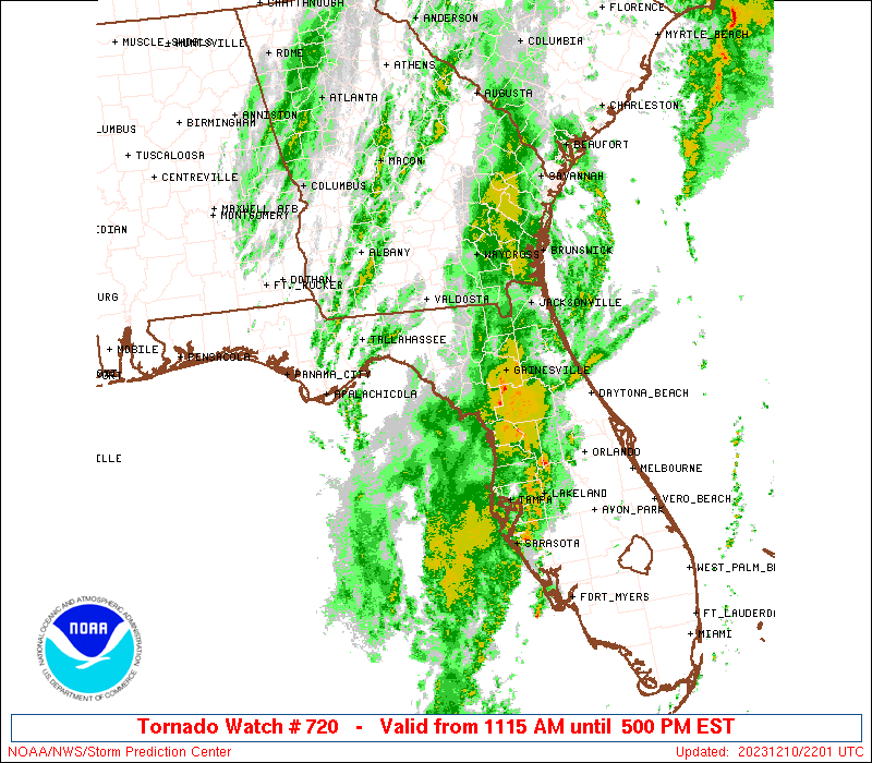
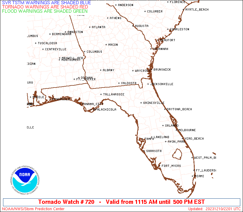
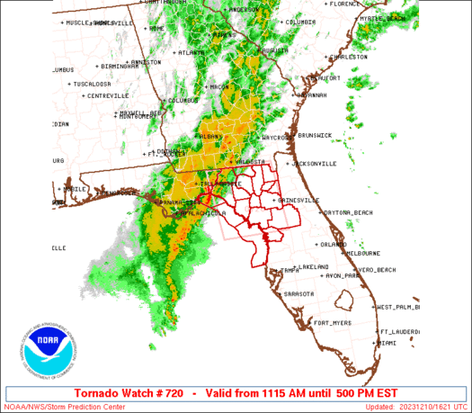
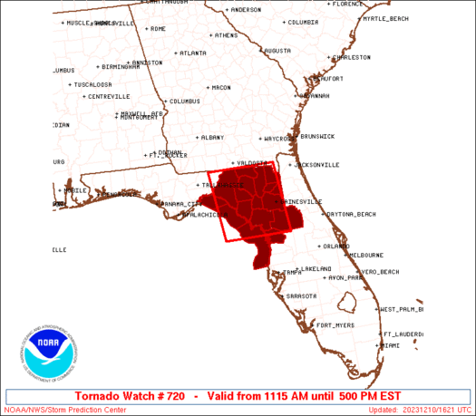
Tornado Watch Number 720
NWS Storm Prediction Center Norman OK
1115 AM EST Sun Dec 10 2023
The NWS Storm Prediction Center has issued a
* Tornado Watch for portions of
Northern Florida
Coastal Waters
* Effective this Sunday morning and afternoon from 1115 AM until
500 PM EST.
* Primary threats include...
A couple tornadoes possible
Isolated damaging wind gusts to 65 mph possible
SUMMARY...Severe storms with a damaging wind and tornado risk, at
least on an isolated basis, are expected to continue across parts of
northern Florida through the afternoon.
The tornado watch area is approximately along and 55 statute miles
east and west of a line from 70 miles north of Cross City FL to 45
miles west southwest of Ocala FL. For a complete depiction of the
watch see the associated watch outline update (WOUS64 KWNS WOU0).
PRECAUTIONARY/PREPAREDNESS ACTIONS...
REMEMBER...A Tornado Watch means conditions are favorable for
tornadoes and severe thunderstorms in and close to the watch
area. Persons in these areas should be on the lookout for
threatening weather conditions and listen for later statements
and possible warnings.
&&
AVIATION...Tornadoes and a few severe thunderstorms with hail
surface and aloft to 1 inch. Extreme turbulence and surface wind
gusts to 55 knots. A few cumulonimbi with maximum tops to 500. Mean
storm motion vector 25030.
...Guyer
   SEL0

   URGENT - IMMEDIATE BROADCAST REQUESTED
   Tornado Watch Number 720
   NWS Storm Prediction Center Norman OK
   1115 AM EST Sun Dec 10 2023

   The NWS Storm Prediction Center has issued a

   * Tornado Watch for portions of
     Northern Florida
     Coastal Waters

   * Effective this Sunday morning and afternoon from 1115 AM until
     500 PM EST.

   * Primary threats include...
     A couple tornadoes possible
     Isolated damaging wind gusts to 65 mph possible

   SUMMARY...Severe storms with a damaging wind and tornado risk, at
   least on an isolated basis, are expected to continue across parts of
   northern Florida through the afternoon.

   The tornado watch area is approximately along and 55 statute miles
   east and west of a line from 70 miles north of Cross City FL to 45
   miles west southwest of Ocala FL. For a complete depiction of the
   watch see the associated watch outline update (WOUS64 KWNS WOU0).

   PRECAUTIONARY/PREPAREDNESS ACTIONS...

   REMEMBER...A Tornado Watch means conditions are favorable for
   tornadoes and severe thunderstorms in and close to the watch
   area. Persons in these areas should be on the lookout for
   threatening weather conditions and listen for later statements
   and possible warnings.

   &&

   AVIATION...Tornadoes and a few severe thunderstorms with hail
   surface and aloft to 1 inch. Extreme turbulence and surface wind
   gusts to 55 knots. A few cumulonimbi with maximum tops to 500. Mean
   storm motion vector 25030.

   ...Guyer
 Note:
The Aviation Watch (SAW) product is an approximation to the watch area.
The actual watch is depicted by the shaded areas.
Note:
The Aviation Watch (SAW) product is an approximation to the watch area.
The actual watch is depicted by the shaded areas.
   SAW0
   WW 720 TORNADO FL CW 101615Z - 102200Z
   AXIS..55 STATUTE MILES EAST AND WEST OF LINE..
   70N CTY/CROSS CITY FL/ - 45WSW OCF/OCALA FL/
   ..AVIATION COORDS.. 50NM E/W /62SSW AMG - 42S CTY/
   HAIL SURFACE AND ALOFT..1 INCH. WIND GUSTS..55 KNOTS.
   MAX TOPS TO 500. MEAN STORM MOTION VECTOR 25030.

   LAT...LON 30648217 28928200 28928382 30648403

   THIS IS AN APPROXIMATION TO THE WATCH AREA.  FOR A
   COMPLETE DEPICTION OF THE WATCH SEE WOUS64 KWNS
   FOR WOU0.
Watch 720 Status Report Messages:
STATUS REPORT #5 ON WW 720

VALID 102130Z - 102200Z

SEVERE WEATHER THREAT CONTINUES RIGHT OF A LINE FROM 50 WSW OCF
TO 30 SSE CTY TO 10 W GNV TO 25 E GNV.

WW 720 WILL BE ALLOWED TO EXPIRE AT 102200Z.

..SQUITIERI..12/10/23

ATTN...WFO...JAX...TBW...TAE...

&&

STATUS REPORT FOR WT 720

SEVERE WEATHER THREAT CONTINUES FOR THE FOLLOWING AREAS

FLC001-017-053-083-101-119-102200-

FL
.    FLORIDA COUNTIES INCLUDED ARE

ALACHUA 	     CITRUS		 HERNANDO
MARION		     PASCO		 SUMTER
$$


GMZ850-102200-

CW

.    ADJACENT COASTAL WATERS INCLUDED ARE

COASTAL WATERS FROM TARPON SPRINGS TO SUWANNEE RIVER FL OUT 20 NM

$$
THE WATCH STATUS MESSAGE IS FOR GUIDANCE PURPOSES ONLY.  PLEASE
REFER TO WATCH COUNTY NOTIFICATION STATEMENTS FOR OFFICIAL
INFORMATION ON COUNTIES...INDEPENDENT CITIES AND MARINE ZONES
CLEARED FROM SEVERE THUNDERSTORM AND TORNADO WATCHES.
$$

STATUS REPORT #4 ON WW 720

VALID 102040Z - 102140Z

SEVERE WEATHER THREAT CONTINUES RIGHT OF A LINE FROM 65 SSW CTY
TO 15 SSE CTY TO 15 WSW JAX.

..SQUITIERI..12/10/23

ATTN...WFO...JAX...TBW...TAE...

&&

STATUS REPORT FOR WT 720

SEVERE WEATHER THREAT CONTINUES FOR THE FOLLOWING AREAS

FLC001-007-017-053-075-083-101-119-125-102140-

FL
.    FLORIDA COUNTIES INCLUDED ARE

ALACHUA 	     BRADFORD		 CITRUS
HERNANDO	     LEVY		 MARION
PASCO		     SUMTER		 UNION
$$


GMZ850-102140-

CW

.    ADJACENT COASTAL WATERS INCLUDED ARE

COASTAL WATERS FROM TARPON SPRINGS TO SUWANNEE RIVER FL OUT 20 NM

$$
THE WATCH STATUS MESSAGE IS FOR GUIDANCE PURPOSES ONLY.  PLEASE
REFER TO WATCH COUNTY NOTIFICATION STATEMENTS FOR OFFICIAL
INFORMATION ON COUNTIES...INDEPENDENT CITIES AND MARINE ZONES
CLEARED FROM SEVERE THUNDERSTORM AND TORNADO WATCHES.
$$

STATUS REPORT #3 ON WW 720

VALID 102000Z - 102140Z

SEVERE WEATHER THREAT CONTINUES RIGHT OF A LINE FROM 65 SW CTY TO
15 SW CTY TO 25 WNW JAX.

..SQUITIERI..12/10/23

ATTN...WFO...JAX...TBW...TAE...

&&

STATUS REPORT FOR WT 720

SEVERE WEATHER THREAT CONTINUES FOR THE FOLLOWING AREAS

FLC001-003-007-017-041-053-075-083-101-119-125-102140-

FL
.    FLORIDA COUNTIES INCLUDED ARE

ALACHUA 	     BAKER		 BRADFORD
CITRUS		     GILCHRIST		 HERNANDO
LEVY		     MARION		 PASCO
SUMTER		     UNION
$$


GMZ850-102140-

CW

.    ADJACENT COASTAL WATERS INCLUDED ARE

COASTAL WATERS FROM TARPON SPRINGS TO SUWANNEE RIVER FL OUT 20 NM

$$
THE WATCH STATUS MESSAGE IS FOR GUIDANCE PURPOSES ONLY.  PLEASE
REFER TO WATCH COUNTY NOTIFICATION STATEMENTS FOR OFFICIAL
INFORMATION ON COUNTIES...INDEPENDENT CITIES AND MARINE ZONES
CLEARED FROM SEVERE THUNDERSTORM AND TORNADO WATCHES.
$$

STATUS REPORT #2 ON WW 720

VALID 101910Z - 102040Z

SEVERE WEATHER THREAT CONTINUES RIGHT OF A LINE FROM 55 WSW CTY
TO 20 NW CTY TO 30 S AYS.

FOR ADDITIONAL INFORMATION SEE MESOSCALE DISCUSSION 2327

..SQUITIERI..12/10/23

ATTN...WFO...JAX...TBW...TAE...

&&

STATUS REPORT FOR WT 720

SEVERE WEATHER THREAT CONTINUES FOR THE FOLLOWING AREAS

FLC001-003-007-017-023-029-041-075-083-125-102040-

FL
.    FLORIDA COUNTIES INCLUDED ARE

ALACHUA 	     BAKER		 BRADFORD
CITRUS		     COLUMBIA		 DIXIE
GILCHRIST	     LEVY		 MARION
UNION
$$


GMZ765-850-102040-

CW

.    ADJACENT COASTAL WATERS INCLUDED ARE

COASTAL WATERS FROM  SUWANNEE RIVER TO KEATON BEACH OUT 20 NM

COASTAL WATERS FROM TARPON SPRINGS TO SUWANNEE RIVER FL OUT 20 NM

$$
THE WATCH STATUS MESSAGE IS FOR GUIDANCE PURPOSES ONLY.  PLEASE
REFER TO WATCH COUNTY NOTIFICATION STATEMENTS FOR OFFICIAL
INFORMATION ON COUNTIES...INDEPENDENT CITIES AND MARINE ZONES
CLEARED FROM SEVERE THUNDERSTORM AND TORNADO WATCHES.
$$

STATUS REPORT #1 ON WW 720

VALID 101805Z - 101940Z

SEVERE WEATHER THREAT CONTINUES RIGHT OF A LINE FROM 55 W CTY TO
35 NNW CTY TO 15 E VLD.

..SQUITIERI..12/10/23

ATTN...WFO...JAX...TBW...TAE...

&&

STATUS REPORT FOR WT 720

SEVERE WEATHER THREAT CONTINUES FOR THE FOLLOWING AREAS

FLC001-003-007-017-023-029-041-047-067-075-083-121-125-101940-

FL
.    FLORIDA COUNTIES INCLUDED ARE

ALACHUA 	     BAKER		 BRADFORD
CITRUS		     COLUMBIA		 DIXIE
GILCHRIST	     HAMILTON		 LAFAYETTE
LEVY		     MARION		 SUWANNEE
UNION
$$


GMZ765-850-101940-

CW

.    ADJACENT COASTAL WATERS INCLUDED ARE

COASTAL WATERS FROM  SUWANNEE RIVER TO KEATON BEACH OUT 20 NM

COASTAL WATERS FROM TARPON SPRINGS TO SUWANNEE RIVER FL OUT 20 NM

$$
THE WATCH STATUS MESSAGE IS FOR GUIDANCE PURPOSES ONLY.  PLEASE
REFER TO WATCH COUNTY NOTIFICATION STATEMENTS FOR OFFICIAL
INFORMATION ON COUNTIES...INDEPENDENT CITIES AND MARINE ZONES
CLEARED FROM SEVERE THUNDERSTORM AND TORNADO WATCHES.
$$
Note:
Click for Complete Product Text.
Tornadoes
Probability of 2 or more tornadoes
|
Mod (40%)
|
Probability of 1 or more strong (EF2-EF5) tornadoes
|
Low (10%)
|
Wind
Probability of 10 or more severe wind events
|
Mod (30%)
|
Probability of 1 or more wind events > 65 knots
|
Low (10%)
|
Hail
Probability of 10 or more severe hail events
|
Low (<5%)
|
Probability of 1 or more hailstones > 2 inches
|
Low (<5%)
|
Combined Severe Hail/Wind
Probability of 6 or more combined severe hail/wind events
|
Mod (50%)
|
For each watch, probabilities for particular events inside the watch
(listed above in each table) are determined by the issuing forecaster.
The "Low" category contains probability values ranging from less than 2%
to 20% (EF2-EF5 tornadoes), less than 5% to 20% (all other probabilities),
"Moderate" from 30% to 60%, and "High" from 70% to greater than 95%.
High values are bolded and lighter in color to provide awareness of
an increased threat for a particular event.


 @NWSSPC